

Remote Sensing Parameterization of Meso-scale ...
409
15.5 Length Scale of Sensible Heat Flux
Surface energy balance studies with remote sensing data are traditionally based on an onedimensional representation of the exchange rates between land and atmosphere. On heterogeneous land surfaces, horizontal advection between different land surface elements however
becomes important and the vertical profiles of horizontal wind speed, heat and vapour may be
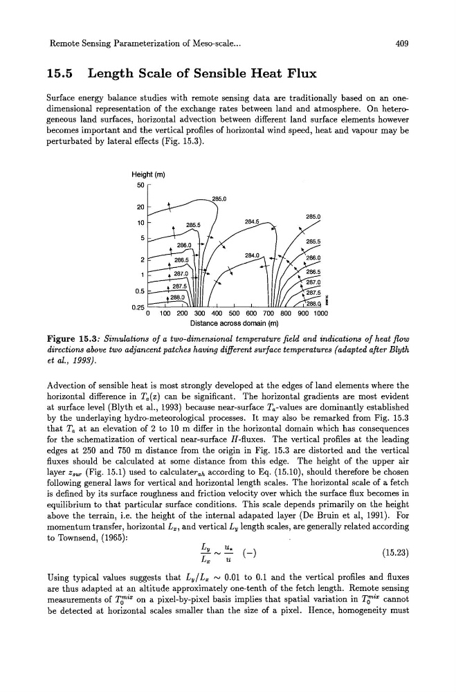
perturbated by lateral effects (Fig. 15.3).
Height (m)
50
285.0
20
10
5
2
0.5
1 00 200 300 400 500 600 700 800
Distance across domain (m)
Figure 15.3: Simulations of a two-dimensional temperature field and indications of heat flow
directions above two adjancent patches having different surface temperatures (adapted after Blyth
et al., 1993).
Advection of sensible heat is most strongly developed at the edges of land elements where the
horizontal difference in Ta(z) can be significant. The horizontal gradients are most evident
at surface level (Blyth et al., 1993) because near-surface Ta-values are dominantly established
by the underlaying hydro-meteorological processes. It may also be remarked from Fig. 15.3
that Ta at an elevation of 2 to 10 m differ in the horizontal domain which has consequences
for the schematization of vertical near-surface H-fluxes. The vertical profiles at the leading
edges at 250 and 750 m distance from the origin in Fig. 15.3 are distorted and the vertical
fluxes should be calculated at some distance from this edge. The height of the upper air
layer Zsur (Fig. 15.1) used to calculaterah according to Eq. (15.10), should therefore be chosen
following general laws for vertical and horizontal length scales. The horizontal scale of a fetch
is defined by its surface roughness and friction velocity over which the surface flux becomes in
equilibrium to that particular surface conditions. This scale depends primarily on the height
above the terrain, i.e. the height of the internal adapated layer (De Bruin et aI, 1991). For
momentum transfer, horizontal Lx, and vertical Ly length scales, are generally related according
to Townsend, (1965):
(15.23)
Using typical values suggests that Ly/ Lx ~ 0.01 to 0.1 and the vertical profiles and fluxes
are thus adapted at an altitude approximately one-tenth of the fetch length. Remote sensing
measurements of TJ:ix on a pixel-by-pixel basis implies that spatial variation in TJ:ix cannot
be detected at horizontal scales smaller than the size of a pixel. Hence, homogeneity must
409
15.5 Length Scale of Sensible Heat Flux
Surface energy balance studies with remote sensing data are traditionally based on an onedimensional representation of the exchange rates between land and atmosphere. On heterogeneous land surfaces, horizontal advection between different land surface elements however
becomes important and the vertical profiles of horizontal wind speed, heat and vapour may be
perturbated by lateral effects (Fig. 15.3).
Height (m)
50
285.0
20
10
5
2
0.5
1 00 200 300 400 500 600 700 800
Distance across domain (m)
Figure 15.3: Simulations of a two-dimensional temperature field and indications of heat flow
directions above two adjancent patches having different surface temperatures (adapted after Blyth
et al., 1993).
Advection of sensible heat is most strongly developed at the edges of land elements where the
horizontal difference in Ta(z) can be significant. The horizontal gradients are most evident
at surface level (Blyth et al., 1993) because near-surface Ta-values are dominantly established
by the underlaying hydro-meteorological processes. It may also be remarked from Fig. 15.3
that Ta at an elevation of 2 to 10 m differ in the horizontal domain which has consequences
for the schematization of vertical near-surface H-fluxes. The vertical profiles at the leading
edges at 250 and 750 m distance from the origin in Fig. 15.3 are distorted and the vertical
fluxes should be calculated at some distance from this edge. The height of the upper air
layer Zsur (Fig. 15.1) used to calculaterah according to Eq. (15.10), should therefore be chosen
following general laws for vertical and horizontal length scales. The horizontal scale of a fetch
is defined by its surface roughness and friction velocity over which the surface flux becomes in
equilibrium to that particular surface conditions. This scale depends primarily on the height
above the terrain, i.e. the height of the internal adapated layer (De Bruin et aI, 1991). For
momentum transfer, horizontal Lx, and vertical Ly length scales, are generally related according
to Townsend, (1965):
(15.23)
Using typical values suggests that Ly/ Lx ~ 0.01 to 0.1 and the vertical profiles and fluxes
are thus adapted at an altitude approximately one-tenth of the fetch length. Remote sensing
measurements of TJ:ix on a pixel-by-pixel basis implies that spatial variation in TJ:ix cannot
be detected at horizontal scales smaller than the size of a pixel. Hence, homogeneity must