

Remote Sensing of Soil Moisture
/
-/
/
387
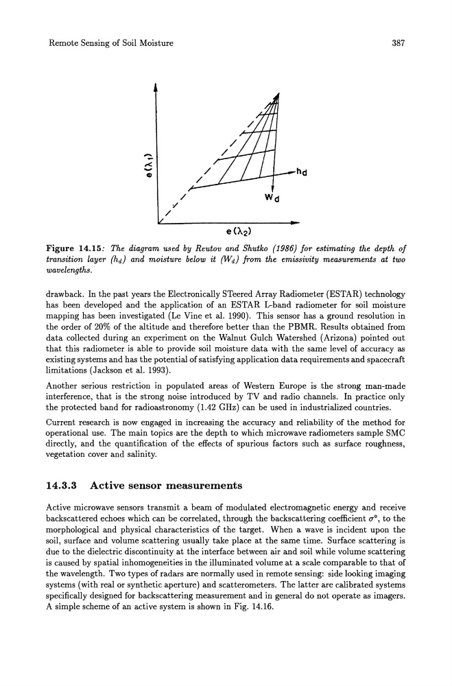
Figure 14.15: The diagram used by Reutov and Shutko (1986) for estimating the depth of
transition layer (hd) and moisture below it (Wd) from the emissivity measurements at two
wavelengths.
drawback. In the past years the Electronically STeered Array Radiometer (ESTAR) technology
has been developed and the application of an ESTAR L-band radiometer for soil moisture
mapping has been investigated (Le Vine et al. 1990). This sensor has a ground resolution in
the order of 20% of the altitude and therefore better than the PBMR. Results obtained from
data collected during an experiment on the Walnut Gulch Watershed (Arizona) pointed out
that this radiometer is able to provide soil moisture data with the same level of accuracy as
existing systems and has the potential of satisfying application data requirements and spacecraft
limitations (Jackson et al. 1993).
Another serious restriction in populated areas of Western Europe is the strong man-made
interference, that is the strong noise introduced by TV and radio channels. In practice only
the protected band for radioastronomy (1.42 GHz) can be used in industrialized countries.
Current research is now engaged in increasing the accuracy and reliability of the method for
operational use. The main topics are the depth to which microwave radiometers sample SMC
directly, and the quantification of the effects of spurious factors such as surface roughness,
vegetation cover and salinity.
14.3.3 Active sensor measurements
Active microwave sensors transmit a beam of modulated electromagnetic energy and receive
backscattered echoes which can be correlated, through the backscattering coefficient ()'o, to the
morphological and physical characteristics of the target. When a wave is incident upon the
soil, surface and volume scattering usually take place at the same time. Surface scattering is
due to the dielectric discontinuity at the interface between air and soil while volume scattering
is caused by spatial inhomogeneities in the illuminated volume at a scale comparable to that of
the wavelength. Two types of radars are normally used in remote sensing: side looking imaging
systems (with real or synthetic aperture) and scatterometers. The latter are calibrated systems
specifically designed for backscattering measurement and in general do not operate as imagers.
A simple scheme of an active system is shown in Fig. 14.16.
/
-/
/
387
Figure 14.15: The diagram used by Reutov and Shutko (1986) for estimating the depth of
transition layer (hd) and moisture below it (Wd) from the emissivity measurements at two
wavelengths.
drawback. In the past years the Electronically STeered Array Radiometer (ESTAR) technology
has been developed and the application of an ESTAR L-band radiometer for soil moisture
mapping has been investigated (Le Vine et al. 1990). This sensor has a ground resolution in
the order of 20% of the altitude and therefore better than the PBMR. Results obtained from
data collected during an experiment on the Walnut Gulch Watershed (Arizona) pointed out
that this radiometer is able to provide soil moisture data with the same level of accuracy as
existing systems and has the potential of satisfying application data requirements and spacecraft
limitations (Jackson et al. 1993).
Another serious restriction in populated areas of Western Europe is the strong man-made
interference, that is the strong noise introduced by TV and radio channels. In practice only
the protected band for radioastronomy (1.42 GHz) can be used in industrialized countries.
Current research is now engaged in increasing the accuracy and reliability of the method for
operational use. The main topics are the depth to which microwave radiometers sample SMC
directly, and the quantification of the effects of spurious factors such as surface roughness,
vegetation cover and salinity.
14.3.3 Active sensor measurements
Active microwave sensors transmit a beam of modulated electromagnetic energy and receive
backscattered echoes which can be correlated, through the backscattering coefficient ()'o, to the
morphological and physical characteristics of the target. When a wave is incident upon the
soil, surface and volume scattering usually take place at the same time. Surface scattering is
due to the dielectric discontinuity at the interface between air and soil while volume scattering
is caused by spatial inhomogeneities in the illuminated volume at a scale comparable to that of
the wavelength. Two types of radars are normally used in remote sensing: side looking imaging
systems (with real or synthetic aperture) and scatterometers. The latter are calibrated systems
specifically designed for backscattering measurement and in general do not operate as imagers.
A simple scheme of an active system is shown in Fig. 14.16.