

Extratropical Cyclones: Their Mesoscale Structure, .. .
135
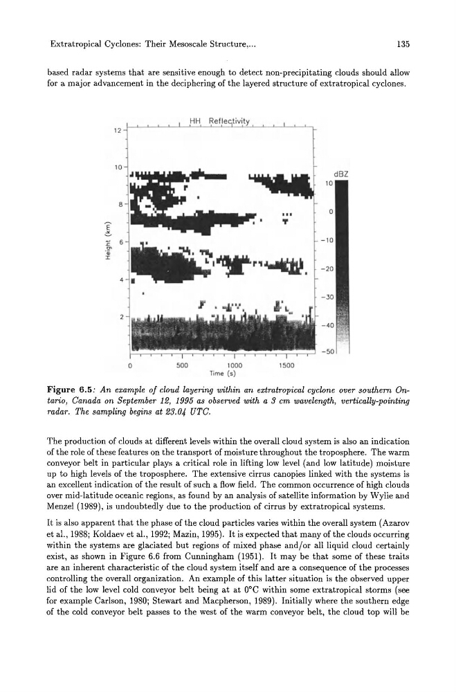
based radar systems that are sensitive enough to detect non-precipitating clouds should allow
for a major advancement in the deciphering of the layered structure of extratropical cyclones.
Figure 6.5: An example of cloud layering within an extratropical cyclone over southern Ontario, Canada on September 12, 1995 as observed with a 3 cm wavelength, vertically-pointing
radar. The sampling begins at 23.04 UTC.
The production of clouds at different levels within the overall cloud system is also an indication
of the role of these features on the transport of moisture throughout the troposphere. The warm
conveyor belt in particular plays a critical role in lifting low level (and low latitude) moisture
up to high levels of the troposphere. The extensive cirrus canopies linked with the systems is
an excellent indication of the result of such a flow field. The common occurrence of high clouds
over mid-latitude oceanic regions, as found by an analysis of satellite information by Wylie and
Menzel (1989), is undoubtedly due to the production of cirrus by extratropical systems.
It is also apparent that the phase of the cloud particles varies within the overall system (Azarov
et al., 1988; Koldaev et al., 1992; Mazin, 1995). It is expected that many of the clouds occurring
within the systems are glaciated but regions of mixed phase and/or all liquid cloud certainly
exist, as shown in Figure 6.6 from Cunningham (1951). It may be that some of these traits
are an inherent characteristic of the cloud system itself and are a consequence of the processes
controlling the overall organization. An example of this latter situation is the observed upper
lid of the low level cold conveyor belt being at at DoC within some extratropical storms (see
for example Carlson, 1980; Stewart and Macpherson, 1989). Initially where the southern edge
of the cold conveyor belt passes to the west of the warm conveyor belt, the cloud top will be
135
based radar systems that are sensitive enough to detect non-precipitating clouds should allow
for a major advancement in the deciphering of the layered structure of extratropical cyclones.
Figure 6.5: An example of cloud layering within an extratropical cyclone over southern Ontario, Canada on September 12, 1995 as observed with a 3 cm wavelength, vertically-pointing
radar. The sampling begins at 23.04 UTC.
The production of clouds at different levels within the overall cloud system is also an indication
of the role of these features on the transport of moisture throughout the troposphere. The warm
conveyor belt in particular plays a critical role in lifting low level (and low latitude) moisture
up to high levels of the troposphere. The extensive cirrus canopies linked with the systems is
an excellent indication of the result of such a flow field. The common occurrence of high clouds
over mid-latitude oceanic regions, as found by an analysis of satellite information by Wylie and
Menzel (1989), is undoubtedly due to the production of cirrus by extratropical systems.
It is also apparent that the phase of the cloud particles varies within the overall system (Azarov
et al., 1988; Koldaev et al., 1992; Mazin, 1995). It is expected that many of the clouds occurring
within the systems are glaciated but regions of mixed phase and/or all liquid cloud certainly
exist, as shown in Figure 6.6 from Cunningham (1951). It may be that some of these traits
are an inherent characteristic of the cloud system itself and are a consequence of the processes
controlling the overall organization. An example of this latter situation is the observed upper
lid of the low level cold conveyor belt being at at DoC within some extratropical storms (see
for example Carlson, 1980; Stewart and Macpherson, 1989). Initially where the southern edge
of the cold conveyor belt passes to the west of the warm conveyor belt, the cloud top will be