

108
M. Cintia Piccolo . Gerardo M.E. Perillo
studied from the geomorphological and dynamical points of view. However, some work
is presently being done at the Quequen Salado, and there are initial approaches at the
Claromeco Estuary.
6.3.1
Mar Chiquita Coastal Lagoon
Mar Chiquita is the only coastal lagoon of Argentine that is chocked with a long inlet.
It is located in the Buenos Aires province between 37°30'S-37° 45'S and 57°3iW (Fig. 6.1).
The lagoon has an elongated shape, with a general direction NNW-SSE. Its length
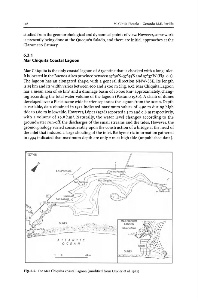
is 25 km and its width varies between 500 and 4500 ill (Fig. 6.5). Mar Chiquita Lagoon
has a mean area of 46 km2 and a drainage basin of 10 000 km 2 approximately, changing according the total water volume of the lagoon (Fassano 1980). A chain of dunes
developed over a Pleistocene wide barrier separates the lagoon from the ocean. Depth
is variable, data obtained in 1972 indicated maximum values of 4.90 m during high
tide to 1.80 m in low tide. However, Lopez (1978) reported 1.5 m and 0.8 m respectively,
with a volume of 36.8 hm3• Naturally, the water level changes according to the
groundwater run-off, the discharges of the small streams and the tides. However, the
geomorphology varied considerably upon the construction of a bridge at the head of
the inlet that induced a large shoaling of the inlet. Bathymetric information gathered
in 1994 indicated that maximum depth are only 2 m at high tide (unpublished data).
37°46'
ATLANTIC
o C E A N
o
4km
MAR CHIQUITA
LAGOON
DUNES
~ . "\. .... - .
Fig. 6.5. The Mar Chiquita coastal lagoon (modified from Olivier et al. 1972)
M. Cintia Piccolo . Gerardo M.E. Perillo
studied from the geomorphological and dynamical points of view. However, some work
is presently being done at the Quequen Salado, and there are initial approaches at the
Claromeco Estuary.
6.3.1
Mar Chiquita Coastal Lagoon
Mar Chiquita is the only coastal lagoon of Argentine that is chocked with a long inlet.
It is located in the Buenos Aires province between 37°30'S-37° 45'S and 57°3iW (Fig. 6.1).
The lagoon has an elongated shape, with a general direction NNW-SSE. Its length
is 25 km and its width varies between 500 and 4500 ill (Fig. 6.5). Mar Chiquita Lagoon
has a mean area of 46 km2 and a drainage basin of 10 000 km 2 approximately, changing according the total water volume of the lagoon (Fassano 1980). A chain of dunes
developed over a Pleistocene wide barrier separates the lagoon from the ocean. Depth
is variable, data obtained in 1972 indicated maximum values of 4.90 m during high
tide to 1.80 m in low tide. However, Lopez (1978) reported 1.5 m and 0.8 m respectively,
with a volume of 36.8 hm3• Naturally, the water level changes according to the
groundwater run-off, the discharges of the small streams and the tides. However, the
geomorphology varied considerably upon the construction of a bridge at the head of
the inlet that induced a large shoaling of the inlet. Bathymetric information gathered
in 1994 indicated that maximum depth are only 2 m at high tide (unpublished data).
37°46'
ATLANTIC
o C E A N
o
4km
MAR CHIQUITA
LAGOON
DUNES
~ . "\. .... - .
Fig. 6.5. The Mar Chiquita coastal lagoon (modified from Olivier et al. 1972)