

378
7. Physically Insignificant FastWaves
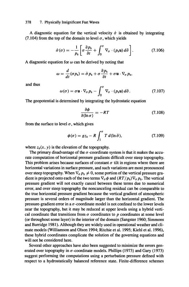
A diagnostic equation for the vertical velocity ä is obtaincd by integrating
(7.104) from the top of the domain to level a , which yields
. ( )
1 [ aPs l
d U -]
(7.106)
a
u u = - - u - + Va' (Psu)
.
Ps
at
0
A diagnostic equation for w can be derived by noting that
d
.
aps
w=-d (ups)=ups+u-+uu,VaPs,
t
and thus
at
w(u) = o u- Va Ps -la Va ' (Psu) da.
(7.107)
The geopotential is determined by integrating the hydrostatic equation
= -RT
(7.108)
a(lnu)
from the surface to level a , which gives
4J(u) = ez« - R la T d(lna),
(7.109)
where zs(x , y) is the elevation ofthe topography.
The primary disadvantage of the a -coordinate system is that it makes the accurate computation of horizontal pressure gradients difficult over steep topography.
This problem arises because surfaces of constant a tilt in regions where there are
horizontal variations in surface pressure, and such variations are most pronounced
over steep topography. When Va Ps :1= 0, some portion of the vertical pressure gradient is projected onto each of the two terms V a4J and (RT / Ps)Va Ps. The vertical
pressure gradient will not exactly cancel between these terms due to numerical
error, and over steep topography the noncanceling residual can be comparable to
the true horizontal pressure gradient because the vertical gradient of atmospheric
pressure is several orders of magnitude larger than the horizontal gradient. The
pressure-gradient error in a c-coordinate model is not confined to the lower levels
near the topography, but it may be reduced at upper levels using a hybrid vertical coordinate that transitions from a coordinates to P coordinates at some level
(or throughout some layer) in the interior of the domain (Sangster 1960; Simmons
and Burridge 1981). Although they are widely used in operation al weather and climate models (Williamson and Olson 1994; Ritchie et aI. 1995; Kiehl et aI. 1996),
these hybrid coordinates complicate the solution of the goveming equations and
will not be considered here.
Several other approaches have also been suggested to minimize the errors generated over topography in a -coordinate models . Phillips (1973) and Gary (1973)
suggest performing the computations using aperturbation pressure defined with
respect to a hydrostatically balanced reference state. Finite-difference schemes
7. Physically Insignificant FastWaves
A diagnostic equation for the vertical velocity ä is obtaincd by integrating
(7.104) from the top of the domain to level a , which yields
. ( )
1 [ aPs l
d U -]
(7.106)
a
u u = - - u - + Va' (Psu)
.
Ps
at
0
A diagnostic equation for w can be derived by noting that
d
.
aps
w=-d (ups)=ups+u-+uu,VaPs,
t
and thus
at
w(u) = o u- Va Ps -la Va ' (Psu) da.
(7.107)
The geopotential is determined by integrating the hydrostatic equation
= -RT
(7.108)
a(lnu)
from the surface to level a , which gives
4J(u) = ez« - R la T d(lna),
(7.109)
where zs(x , y) is the elevation ofthe topography.
The primary disadvantage of the a -coordinate system is that it makes the accurate computation of horizontal pressure gradients difficult over steep topography.
This problem arises because surfaces of constant a tilt in regions where there are
horizontal variations in surface pressure, and such variations are most pronounced
over steep topography. When Va Ps :1= 0, some portion of the vertical pressure gradient is projected onto each of the two terms V a4J and (RT / Ps)Va Ps. The vertical
pressure gradient will not exactly cancel between these terms due to numerical
error, and over steep topography the noncanceling residual can be comparable to
the true horizontal pressure gradient because the vertical gradient of atmospheric
pressure is several orders of magnitude larger than the horizontal gradient. The
pressure-gradient error in a c-coordinate model is not confined to the lower levels
near the topography, but it may be reduced at upper levels using a hybrid vertical coordinate that transitions from a coordinates to P coordinates at some level
(or throughout some layer) in the interior of the domain (Sangster 1960; Simmons
and Burridge 1981). Although they are widely used in operation al weather and climate models (Williamson and Olson 1994; Ritchie et aI. 1995; Kiehl et aI. 1996),
these hybrid coordinates complicate the solution of the goveming equations and
will not be considered here.
Several other approaches have also been suggested to minimize the errors generated over topography in a -coordinate models . Phillips (1973) and Gary (1973)
suggest performing the computations using aperturbation pressure defined with
respect to a hydrostatically balanced reference state. Finite-difference schemes