

3.3 Imagery standards
101
ters etc., are the domain ofISO 19130. All rules ofISO 19123 (Schema for coverage
geometry and functions) assume georeferenced data like ISO 19129.
ISOITR 19121 (Imagery and gridded data)
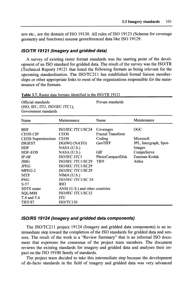
A survey of existing raster format standards was the starting point of the development of an ISO standard for gridded data. The result of the survey was the ISO/TR
(Technical Report) 19121 that listed the following formats as being relevant for the
upcoming standardisation. The ISO/TC211 has established formal liaison memberships or other appropriate links to most of the organizations responsible for the maintenance of the formats.
Table 3.7. Raster data formats identified in the ISO/TR 19121
Official standards
(ISO, lEC, ITU, ISO/lEC JTC1),
Govemment standards
Name
Maintenance
BIlF
ISO/lEC JTC lISC24
CEOS CIP
CEOS
CEOS Superstructure CEOS
DIGEST
DGIWG (NATO)
HDF
NASA (U.S.)
HDF-EOS
NASA (U.S.)
IP-IlF
ISO/lEC JTC 1
JBIG
ISO/lEC JTClISC29
JPEG
ISO/lEC JTC1/SC29
MPEG-2
ISO/lEC JTClISC29
NITF
NIMA(U.S.)
PNG
ISO/lEC JTC lISC 24
S-57
IHO
Private standards
Name
Coverages
Fractal Transform
Coding
GeoTIFF
GIF
PhotoCampactDisk
TIFF
SDTS raster
ANSI (U.S.) and other countries
SQLlMM
ISO/lEC JTClISC32
TA and T.6
ITU
TIFF/IT
ISO/TCI30
Maintenance
OGC
Microsoft
JPL, Intergraph, SpotImages
CompuServe
Eastman Kodak
Aldus
ISOIRS 19124 (Imagery and gridded data components)
The ISO/TC211 project 19124 (Imagery and gridded data components) is an intermediate step toward the completion of the ISO standards for gridded data and sensors. The result of the work is a "Review Summary" that is an informal ISO document that expresses the consensus of the project team members. The document
reviews the existing standards for imagery and gridded data and analyses their impact on the ISO 19100 family of standards.
The project team decided to take this intermediate step because the development
of de-facto standards in the field of imagery and gridded data was very advanced
101
ters etc., are the domain ofISO 19130. All rules ofISO 19123 (Schema for coverage
geometry and functions) assume georeferenced data like ISO 19129.
ISOITR 19121 (Imagery and gridded data)
A survey of existing raster format standards was the starting point of the development of an ISO standard for gridded data. The result of the survey was the ISO/TR
(Technical Report) 19121 that listed the following formats as being relevant for the
upcoming standardisation. The ISO/TC211 has established formal liaison memberships or other appropriate links to most of the organizations responsible for the maintenance of the formats.
Table 3.7. Raster data formats identified in the ISO/TR 19121
Official standards
(ISO, lEC, ITU, ISO/lEC JTC1),
Govemment standards
Name
Maintenance
BIlF
ISO/lEC JTC lISC24
CEOS CIP
CEOS
CEOS Superstructure CEOS
DIGEST
DGIWG (NATO)
HDF
NASA (U.S.)
HDF-EOS
NASA (U.S.)
IP-IlF
ISO/lEC JTC 1
JBIG
ISO/lEC JTClISC29
JPEG
ISO/lEC JTC1/SC29
MPEG-2
ISO/lEC JTClISC29
NITF
NIMA(U.S.)
PNG
ISO/lEC JTC lISC 24
S-57
IHO
Private standards
Name
Coverages
Fractal Transform
Coding
GeoTIFF
GIF
PhotoCampactDisk
TIFF
SDTS raster
ANSI (U.S.) and other countries
SQLlMM
ISO/lEC JTClISC32
TA and T.6
ITU
TIFF/IT
ISO/TCI30
Maintenance
OGC
Microsoft
JPL, Intergraph, SpotImages
CompuServe
Eastman Kodak
Aldus
ISOIRS 19124 (Imagery and gridded data components)
The ISO/TC211 project 19124 (Imagery and gridded data components) is an intermediate step toward the completion of the ISO standards for gridded data and sensors. The result of the work is a "Review Summary" that is an informal ISO document that expresses the consensus of the project team members. The document
reviews the existing standards for imagery and gridded data and analyses their impact on the ISO 19100 family of standards.
The project team decided to take this intermediate step because the development
of de-facto standards in the field of imagery and gridded data was very advanced