

102
3 Non-geometry standards
outside of ISO. In addition, the ISO/TC211 had agreed on the project 19123
(Schema for coverage geometry and functions) that is considered a superset of gridded data, and both created a situation that strongly required an alignment with existing solutions.
The existing standards listed in the ISO/TR 19121 were analysed using the following components: data model/schema, metadata, encoding, services, and spatial
registration. These analyses resulted in a proposed amendment of the ISO 19115
(Metadata). The two other standards of the ISO 19100 family that require smaller
amendments are the ISO 19104 (Terminology) and the ISO 19113 (Quality principIes).
3.3.2 Sensors (ISO 19130)
Remotely sensed data is an important source for geographic information. Data are
called remotely sensed if the sensor has no physical contact with the measured object. For the use of such data in combination with other geographic information, the
remotely sensed data must be geometrically referenced to the earth. The ISO 19130
(Sensor and data models far imagery and gridded data) standardises the metadata for
the geometrie reference of the originally sensed data to locations on the earth. This
reference allows for more precise data retrieval from the imagery. For most applications it is aprerequisite for an appropriate use ofthe imagery.
Sensor classification
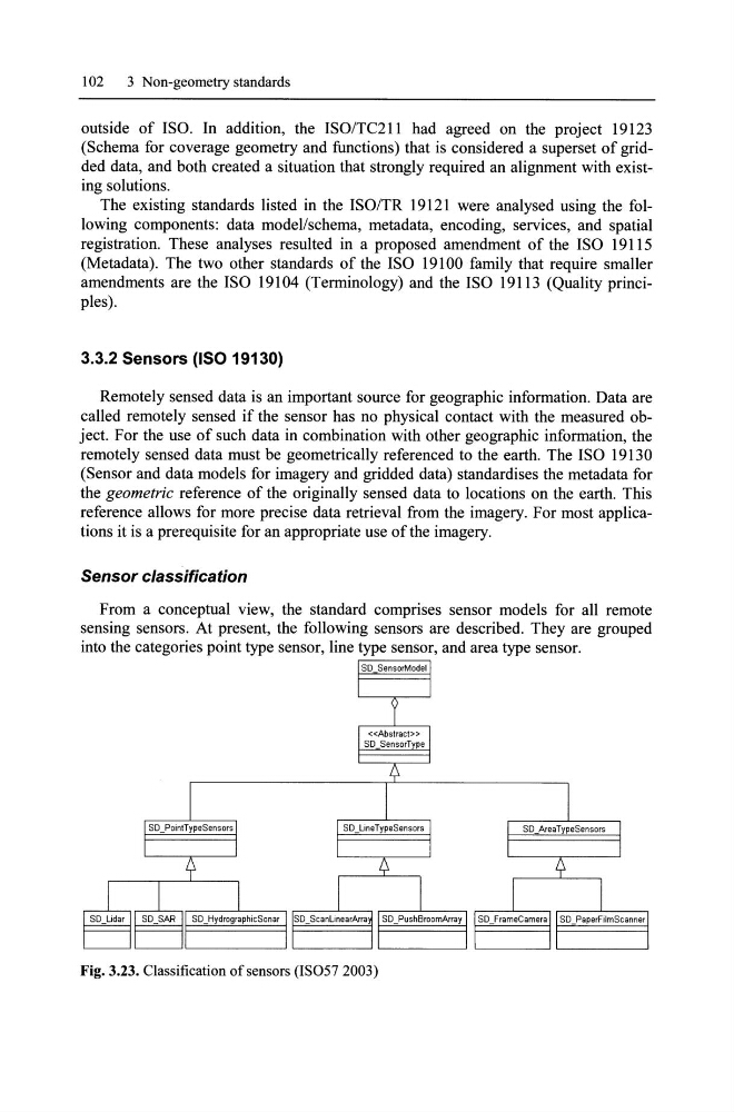
From a conceptual view, the standard comprises sensor models for all remote
sensing sensors. At present, the following sensors are described. They are grouped
into the categaries point type sensor, line type sensor, and area type sensor.
Fig. 3.23. Classification of sensors (IS057 2003)
3 Non-geometry standards
outside of ISO. In addition, the ISO/TC211 had agreed on the project 19123
(Schema for coverage geometry and functions) that is considered a superset of gridded data, and both created a situation that strongly required an alignment with existing solutions.
The existing standards listed in the ISO/TR 19121 were analysed using the following components: data model/schema, metadata, encoding, services, and spatial
registration. These analyses resulted in a proposed amendment of the ISO 19115
(Metadata). The two other standards of the ISO 19100 family that require smaller
amendments are the ISO 19104 (Terminology) and the ISO 19113 (Quality principIes).
3.3.2 Sensors (ISO 19130)
Remotely sensed data is an important source for geographic information. Data are
called remotely sensed if the sensor has no physical contact with the measured object. For the use of such data in combination with other geographic information, the
remotely sensed data must be geometrically referenced to the earth. The ISO 19130
(Sensor and data models far imagery and gridded data) standardises the metadata for
the geometrie reference of the originally sensed data to locations on the earth. This
reference allows for more precise data retrieval from the imagery. For most applications it is aprerequisite for an appropriate use ofthe imagery.
Sensor classification
From a conceptual view, the standard comprises sensor models for all remote
sensing sensors. At present, the following sensors are described. They are grouped
into the categaries point type sensor, line type sensor, and area type sensor.
Fig. 3.23. Classification of sensors (IS057 2003)