

100
3 Non-geometry standards
dimensions, like the x and y. The result is a ground-plan of the dataset. This is the
way maps are usually displayed.
I
Imagery dataset
I
H ungeoreferenced dataset I
H ungeoreferenceable dataset I
georeferenceable dataset I
H
Image reference
I
H Coefficients. corners I
Control points
I
Sensor reference
H
Orientation data
I
Control points
I
I
Georeferenced dataset I
H
Ungeorectified dataset
I
I
Georectified dataset
I
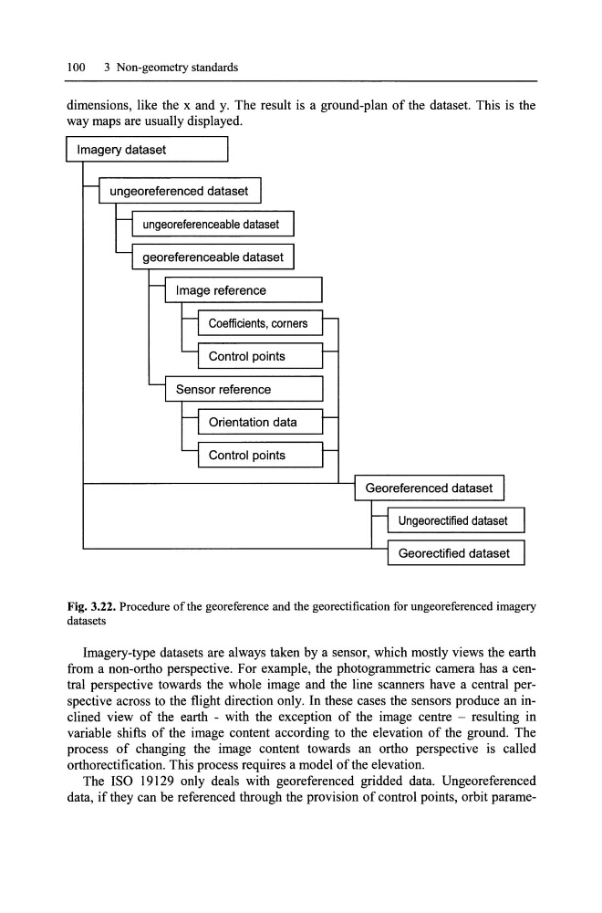
Fig. 3.22. Procedure of the georeference and the georectification for ungeoreferenced imagery
datasets
Imagery-type datasets are always taken by a sensor, which mostly views the earth
from a non-ortho perspective. For example, the photogrammetric camera has a central perspective towards the whole image and the line scanners have a central perspective across to the flight direction only. In these cases the sensors produce an inclined view of the earth - with the exception of the image centre - resulting in
variable shifts of the image content according to the elevation of the ground. The
process of changing the image content towards an ortho perspective is called
orthorectification. This process requires a model ofthe elevation.
The ISO 19129 only deals with georeferenced gridded data. Ungeoreferenced
data, if they can be referenced through the provision of control points, orbit parame-
3 Non-geometry standards
dimensions, like the x and y. The result is a ground-plan of the dataset. This is the
way maps are usually displayed.
I
Imagery dataset
I
H ungeoreferenced dataset I
H ungeoreferenceable dataset I
georeferenceable dataset I
H
Image reference
I
H Coefficients. corners I
Control points
I
Sensor reference
H
Orientation data
I
Control points
I
I
Georeferenced dataset I
H
Ungeorectified dataset
I
I
Georectified dataset
I
Fig. 3.22. Procedure of the georeference and the georectification for ungeoreferenced imagery
datasets
Imagery-type datasets are always taken by a sensor, which mostly views the earth
from a non-ortho perspective. For example, the photogrammetric camera has a central perspective towards the whole image and the line scanners have a central perspective across to the flight direction only. In these cases the sensors produce an inclined view of the earth - with the exception of the image centre - resulting in
variable shifts of the image content according to the elevation of the ground. The
process of changing the image content towards an ortho perspective is called
orthorectification. This process requires a model ofthe elevation.
The ISO 19129 only deals with georeferenced gridded data. Ungeoreferenced
data, if they can be referenced through the provision of control points, orbit parame-