

368
M. A. Chapman et al.
1) determine whether a point is inside, outside, or on the boundary of a polygon,
and
2) determine in which probability region the point falls.
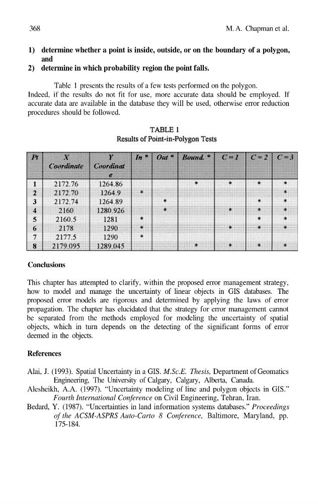
Table 1 presents the results of a few tests performed on the polygon.
Indeed, if the results do not fit for use, more accurate data should be employed. If
accurate data are available in the database they will be used, otherwise error reduction
procedures should be followed.
Conclusions
This chapter has attempted to clarify, within the proposed error management strategy,
how to model and manage the uncertainty of linear objects in GIS databases. The
proposed error models are rigorous and determined by applying the laws of error
propagation. The chapter has elucidated that the strategy for error management cannot
be separated from the methods employed for modeling the uncertainty of spatial
objects, which in turn depends on the detecting of the significant forms of error
deemed in the objects.
References
Alai, J. (1993). Spatial Uncertainty in a GIS. M.Sc.E. Thesis, Department of Geomatics
Engineering, The University of Calgary, Calgary, Alberta, Canada.
Alesheikh, A.A. (1997). “Uncertainty modeling of line and polygon objects in GIS.”
Fourth International Conference on Civil Engineering, Tehran, Iran.
Bedard, Y. (1987). “Uncertainties in land information systems databases.” Proceedings
of the ACSM-ASPRS Auto-Carto 8 Conference, Baltimore, Maryland, pp.
175-184.
M. A. Chapman et al.
1) determine whether a point is inside, outside, or on the boundary of a polygon,
and
2) determine in which probability region the point falls.
Table 1 presents the results of a few tests performed on the polygon.
Indeed, if the results do not fit for use, more accurate data should be employed. If
accurate data are available in the database they will be used, otherwise error reduction
procedures should be followed.
Conclusions
This chapter has attempted to clarify, within the proposed error management strategy,
how to model and manage the uncertainty of linear objects in GIS databases. The
proposed error models are rigorous and determined by applying the laws of error
propagation. The chapter has elucidated that the strategy for error management cannot
be separated from the methods employed for modeling the uncertainty of spatial
objects, which in turn depends on the detecting of the significant forms of error
deemed in the objects.
References
Alai, J. (1993). Spatial Uncertainty in a GIS. M.Sc.E. Thesis, Department of Geomatics
Engineering, The University of Calgary, Calgary, Alberta, Canada.
Alesheikh, A.A. (1997). “Uncertainty modeling of line and polygon objects in GIS.”
Fourth International Conference on Civil Engineering, Tehran, Iran.
Bedard, Y. (1987). “Uncertainties in land information systems databases.” Proceedings
of the ACSM-ASPRS Auto-Carto 8 Conference, Baltimore, Maryland, pp.
175-184.