

352
U. Lohr
DEMs for Various Applications
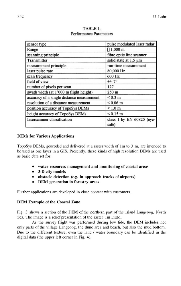
TopoSys DEMs, geocoded and delivered at a raster width of 1m to 3 m, are intended to
be used as one layer in a GIS. Presently, these kinds of high resolution DEMs are used
as basic data set for:
water resources management and monitoring of coastal areas
3-D city models
obstacle detection (e.g. in approach tracks of airports)
DEM generation in forestry areas
Further applications are developed in close contact with customers.
DEM Example of the Coastal Zone
Fig. 3 shows a section of the DEM of the northern part of the island Langeoog, North
Sea. The image is a relief presentation of the raster 1m DEM.
As the survey flight was performed during low tide, the DEM includes not
only parts of the village Langeoog, the dune area and beach, but also the mud bottom.
Due to the different texture, even the land / water boundary can be identified in the
digital data (the upper left corner in Fig. 4).
U. Lohr
DEMs for Various Applications
TopoSys DEMs, geocoded and delivered at a raster width of 1m to 3 m, are intended to
be used as one layer in a GIS. Presently, these kinds of high resolution DEMs are used
as basic data set for:
water resources management and monitoring of coastal areas
3-D city models
obstacle detection (e.g. in approach tracks of airports)
DEM generation in forestry areas
Further applications are developed in close contact with customers.
DEM Example of the Coastal Zone
Fig. 3 shows a section of the DEM of the northern part of the island Langeoog, North
Sea. The image is a relief presentation of the raster 1m DEM.
As the survey flight was performed during low tide, the DEM includes not
only parts of the village Langeoog, the dune area and beach, but also the mud bottom.
Due to the different texture, even the land / water boundary can be identified in the
digital data (the upper left corner in Fig. 4).