

Digital Elevation Models by Laserscanning
351
at the borders of the scan. The small scan angle in combination with the high measurement rate forms the basis for reliable distance measurements and the high quality
DEMs.
The off-line processing system includes several UNIX workstations. The key
software packages are the software package for flight path restitution and the TopoSys
package for DEM generation and elimination of vegetation cover. Further tools allow
the fusion of digital data from various sensors and an image processing software package supports DEM visualisation and quality control.
The primary output of the DEM production process is a 16 bit raster DEM,
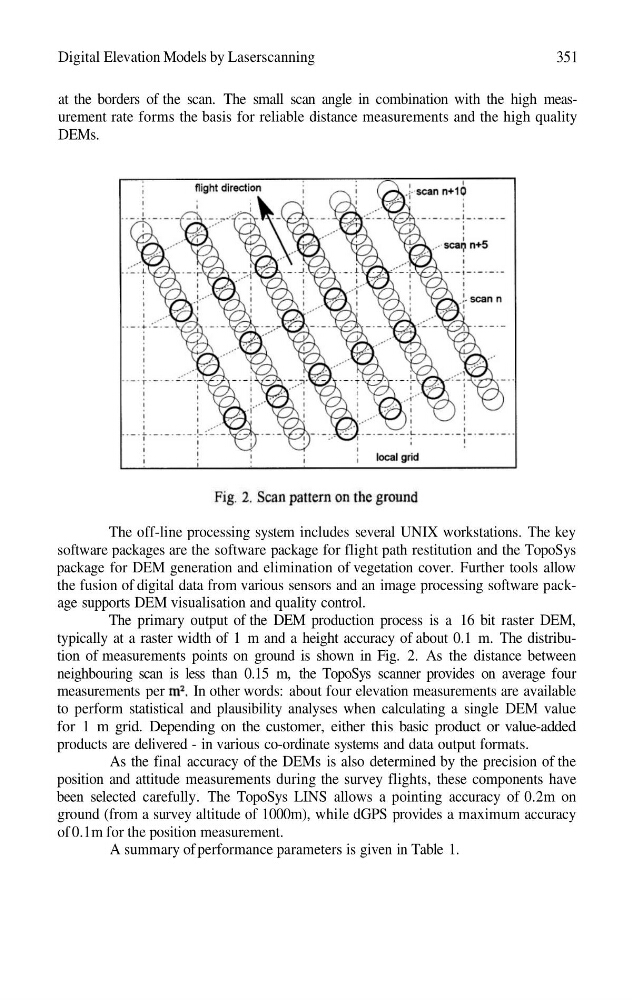
typically at a raster width of 1 m and a height accuracy of about 0.1 m. The distribution of measurements points on ground is shown in Fig. 2. As the distance between
neighbouring scan is less than 0.15 m, the TopoSys scanner provides on average four
measurements per
In other words: about four elevation measurements are available
to perform statistical and plausibility analyses when calculating a single DEM value
for 1 m grid. Depending on the customer, either this basic product or value-added
products are delivered - in various co-ordinate systems and data output formats.
As the final accuracy of the DEMs is also determined by the precision of the
position and attitude measurements during the survey flights, these components have
been selected carefully. The TopoSys LINS allows a pointing accuracy of 0.2m on
ground (from a survey altitude of 1000m), while dGPS provides a maximum accuracy
of 0.1m for the position measurement.
A summary of performance parameters is given in Table 1.
351
at the borders of the scan. The small scan angle in combination with the high measurement rate forms the basis for reliable distance measurements and the high quality
DEMs.
The off-line processing system includes several UNIX workstations. The key
software packages are the software package for flight path restitution and the TopoSys
package for DEM generation and elimination of vegetation cover. Further tools allow
the fusion of digital data from various sensors and an image processing software package supports DEM visualisation and quality control.
The primary output of the DEM production process is a 16 bit raster DEM,
typically at a raster width of 1 m and a height accuracy of about 0.1 m. The distribution of measurements points on ground is shown in Fig. 2. As the distance between
neighbouring scan is less than 0.15 m, the TopoSys scanner provides on average four
measurements per
In other words: about four elevation measurements are available
to perform statistical and plausibility analyses when calculating a single DEM value
for 1 m grid. Depending on the customer, either this basic product or value-added
products are delivered - in various co-ordinate systems and data output formats.
As the final accuracy of the DEMs is also determined by the precision of the
position and attitude measurements during the survey flights, these components have
been selected carefully. The TopoSys LINS allows a pointing accuracy of 0.2m on
ground (from a survey altitude of 1000m), while dGPS provides a maximum accuracy
of 0.1m for the position measurement.
A summary of performance parameters is given in Table 1.