

350
U. Lohr
Description of the System
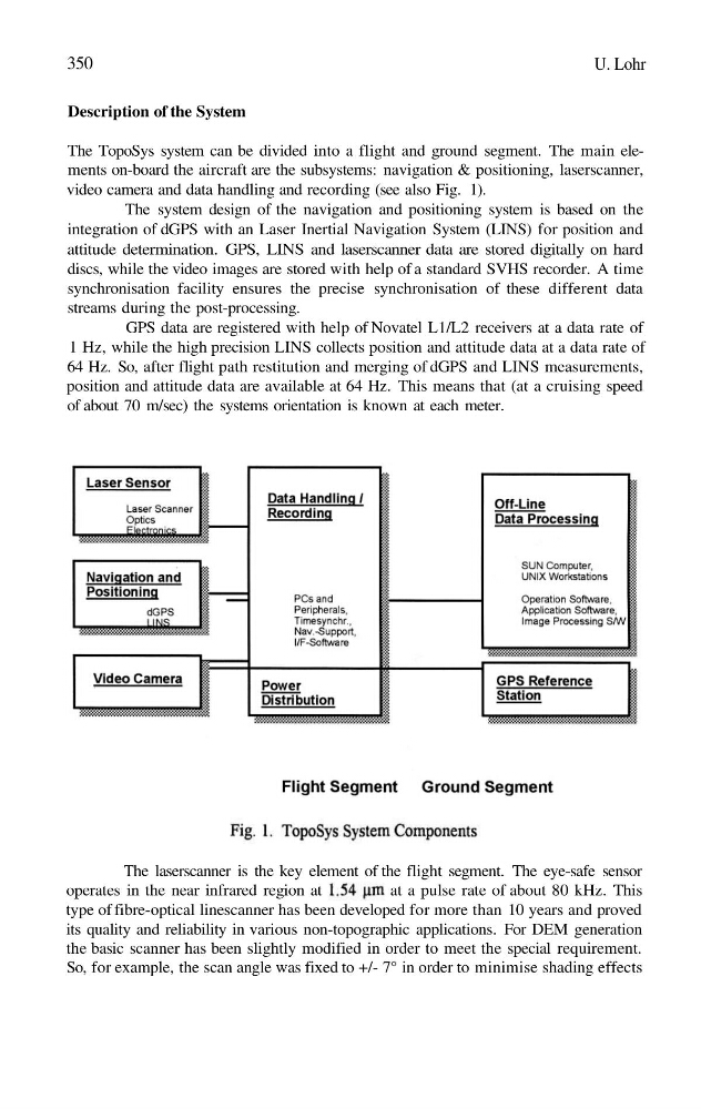
The TopoSys system can be divided into a flight and ground segment. The main elements on-board the aircraft are the subsystems: navigation & positioning, laserscanner,
video camera and data handling and recording (see also Fig. 1).
The system design of the navigation and positioning system is based on the
integration of dGPS with an Laser Inertial Navigation System (LINS) for position and
attitude determination. GPS, LINS and laserscanner data are stored digitally on hard
discs, while the video images are stored with help of a standard SVHS recorder. A time
synchronisation facility ensures the precise synchronisation of these different data
streams during the post-processing.
GPS data are registered with help of Novatel L1/L2 receivers at a data rate of
1 Hz, while the high precision LINS collects position and attitude data at a data rate of
64 Hz. So, after flight path restitution and merging of dGPS and LINS measurements,
position and attitude data are available at 64 Hz. This means that (at a cruising speed
of about 70 m/sec) the systems orientation is known at each meter.
The laserscanner is the key element of the flight segment. The eye-safe sensor
operates in the near infrared region at
at a pulse rate of about 80 kHz. This
type of fibre-optical linescanner has been developed for more than 10 years and proved
its quality and reliability in various non-topographic applications. For DEM generation
the basic scanner has been slightly modified in order to meet the special requirement.
So, for example, the scan angle was fixed to +/- 7° in order to minimise shading effects
U. Lohr
Description of the System
The TopoSys system can be divided into a flight and ground segment. The main elements on-board the aircraft are the subsystems: navigation & positioning, laserscanner,
video camera and data handling and recording (see also Fig. 1).
The system design of the navigation and positioning system is based on the
integration of dGPS with an Laser Inertial Navigation System (LINS) for position and
attitude determination. GPS, LINS and laserscanner data are stored digitally on hard
discs, while the video images are stored with help of a standard SVHS recorder. A time
synchronisation facility ensures the precise synchronisation of these different data
streams during the post-processing.
GPS data are registered with help of Novatel L1/L2 receivers at a data rate of
1 Hz, while the high precision LINS collects position and attitude data at a data rate of
64 Hz. So, after flight path restitution and merging of dGPS and LINS measurements,
position and attitude data are available at 64 Hz. This means that (at a cruising speed
of about 70 m/sec) the systems orientation is known at each meter.
The laserscanner is the key element of the flight segment. The eye-safe sensor
operates in the near infrared region at
at a pulse rate of about 80 kHz. This
type of fibre-optical linescanner has been developed for more than 10 years and proved
its quality and reliability in various non-topographic applications. For DEM generation
the basic scanner has been slightly modified in order to meet the special requirement.
So, for example, the scan angle was fixed to +/- 7° in order to minimise shading effects