

218
Rodríguez et al.
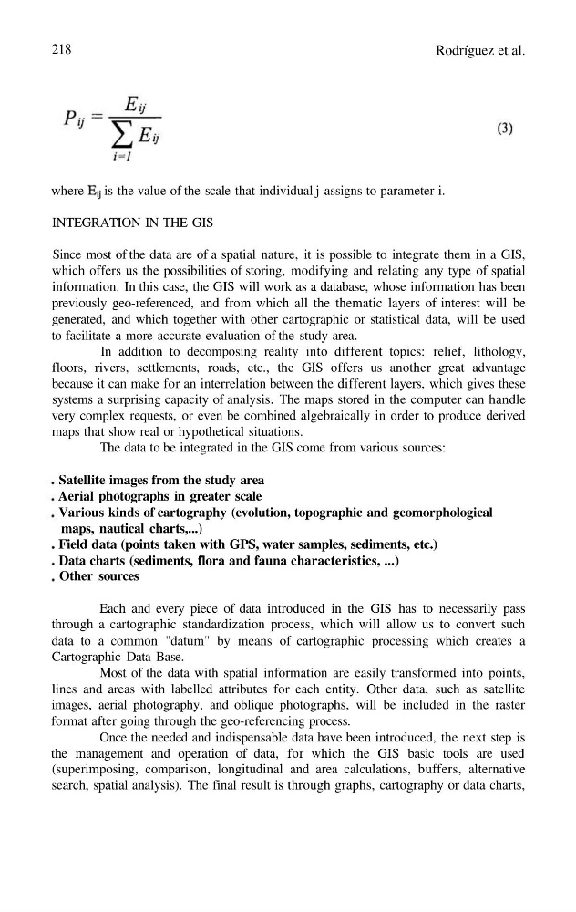
where is the value of the scale that individual j assigns to parameter i.
INTEGRATION IN THE GIS
Since most of the data are of a spatial nature, it is possible to integrate them in a GIS,
which offers us the possibilities of storing, modifying and relating any type of spatial
information. In this case, the GIS will work as a database, whose information has been
previously geo-referenced, and from which all the thematic layers of interest will be
generated, and which together with other cartographic or statistical data, will be used
to facilitate a more accurate evaluation of the study area.
In addition to decomposing reality into different topics: relief, lithology,
floors, rivers, settlements, roads, etc., the GIS offers us another great advantage
because it can make for an interrelation between the different layers, which gives these
systems a surprising capacity of analysis. The maps stored in the computer can handle
very complex requests, or even be combined algebraically in order to produce derived
maps that show real or hypothetical situations.
The data to be integrated in the GIS come from various sources:
Satellite images from the study area
Aerial photographs in greater scale
Various kinds of cartography (evolution, topographic and geomorphological
maps, nautical charts,...)
Field data (points taken with GPS, water samples, sediments, etc.)
Data charts (sediments, flora and fauna characteristics, ...)
Other sources
Each and every piece of data introduced in the GIS has to necessarily pass
through a cartographic standardization process, which will allow us to convert such
data to a common "datum" by means of cartographic processing which creates a
Cartographic Data Base.
Most of the data with spatial information are easily transformed into points,
lines and areas with labelled attributes for each entity. Other data, such as satellite
images, aerial photography, and oblique photographs, will be included in the raster
format after going through the geo-referencing process.
Once the needed and indispensable data have been introduced, the next step is
the management and operation of data, for which the GIS basic tools are used
(superimposing, comparison, longitudinal and area calculations, buffers, alternative
search, spatial analysis). The final result is through graphs, cartography or data charts,
Rodríguez et al.
where is the value of the scale that individual j assigns to parameter i.
INTEGRATION IN THE GIS
Since most of the data are of a spatial nature, it is possible to integrate them in a GIS,
which offers us the possibilities of storing, modifying and relating any type of spatial
information. In this case, the GIS will work as a database, whose information has been
previously geo-referenced, and from which all the thematic layers of interest will be
generated, and which together with other cartographic or statistical data, will be used
to facilitate a more accurate evaluation of the study area.
In addition to decomposing reality into different topics: relief, lithology,
floors, rivers, settlements, roads, etc., the GIS offers us another great advantage
because it can make for an interrelation between the different layers, which gives these
systems a surprising capacity of analysis. The maps stored in the computer can handle
very complex requests, or even be combined algebraically in order to produce derived
maps that show real or hypothetical situations.
The data to be integrated in the GIS come from various sources:
Satellite images from the study area
Aerial photographs in greater scale
Various kinds of cartography (evolution, topographic and geomorphological
maps, nautical charts,...)
Field data (points taken with GPS, water samples, sediments, etc.)
Data charts (sediments, flora and fauna characteristics, ...)
Other sources
Each and every piece of data introduced in the GIS has to necessarily pass
through a cartographic standardization process, which will allow us to convert such
data to a common "datum" by means of cartographic processing which creates a
Cartographic Data Base.
Most of the data with spatial information are easily transformed into points,
lines and areas with labelled attributes for each entity. Other data, such as satellite
images, aerial photography, and oblique photographs, will be included in the raster
format after going through the geo-referencing process.
Once the needed and indispensable data have been introduced, the next step is
the management and operation of data, for which the GIS basic tools are used
(superimposing, comparison, longitudinal and area calculations, buffers, alternative
search, spatial analysis). The final result is through graphs, cartography or data charts,