

Atmospheric Boundary Layer: Concepts and Measurements
27
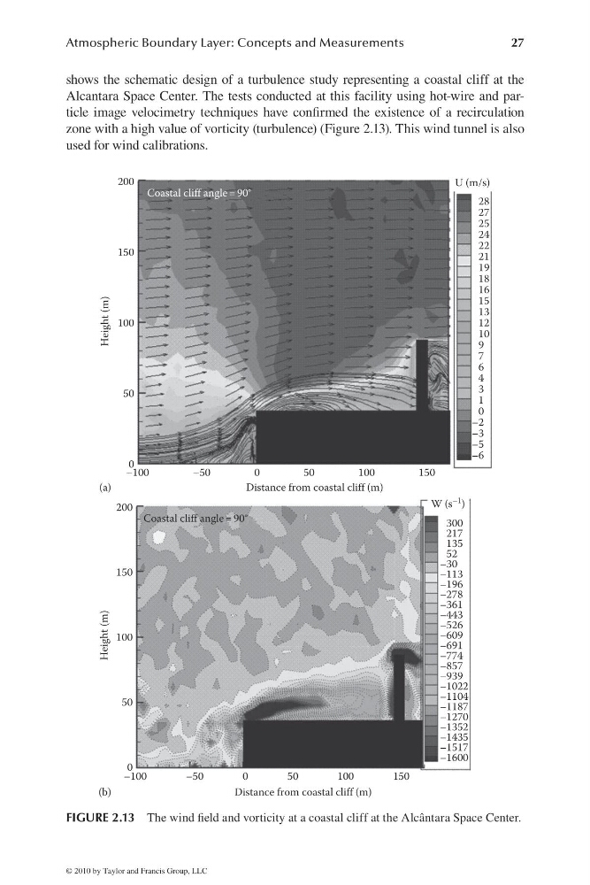
shows the schematic design of a turbulence study representing a coastal cliff at the
Alcantara Space Center. The tests conducted at this facility using hot-wire and particle image velocimetry techniques have confi rmed the existence of a recirculation
zone with a high value of vorticity (turbulence) (Figure 2.13). This wind tunnel is also
used for wind calibrations.
(a)
200
150
100
50
0
–100
–50
0
50
Distance from coastal cliff (m)
Coastal cliff angle = 90°
Height (m)
100
150
28
U (m/s)
27
25
24
22
21
19
18
16
15
13
12
10
9
7
6
4
3
1
0
–2
–3
–5
–6
(b)
200
Coastal cliff angle = 90°
150
100
50
0
–100
–50
0
50
Distance from coastal cliff (m)
Height (m)
100
150
300
W (s
–1 )
217
135
52
–30
–113
–196
–278
–361
–443
–526
–609
–691
–774
–857
–939
–1022
–1104
–1187
–1270
–1352
–1435
–1517
–1600
FIGURE 2.13 The wind fi eld and vorticity at a coastal cliff at the Alcântara Space Center.
© 2010 by Taylor and Francis Group, LLC
27
shows the schematic design of a turbulence study representing a coastal cliff at the
Alcantara Space Center. The tests conducted at this facility using hot-wire and particle image velocimetry techniques have confi rmed the existence of a recirculation
zone with a high value of vorticity (turbulence) (Figure 2.13). This wind tunnel is also
used for wind calibrations.
(a)
200
150
100
50
0
–100
–50
0
50
Distance from coastal cliff (m)
Coastal cliff angle = 90°
Height (m)
100
150
28
U (m/s)
27
25
24
22
21
19
18
16
15
13
12
10
9
7
6
4
3
1
0
–2
–3
–5
–6
(b)
200
Coastal cliff angle = 90°
150
100
50
0
–100
–50
0
50
Distance from coastal cliff (m)
Height (m)
100
150
300
W (s
–1 )
217
135
52
–30
–113
–196
–278
–361
–443
–526
–609
–691
–774
–857
–939
–1022
–1104
–1187
–1270
–1352
–1435
–1517
–1600
FIGURE 2.13 The wind fi eld and vorticity at a coastal cliff at the Alcântara Space Center.
© 2010 by Taylor and Francis Group, LLC