

348
P.J. Lechler
consistent with observations from area (1), indicating higher proportions of other
Hg species in near-surface horizons where Hg probably becomes more strongly
associated with organic matter in weakly developed A-horizons or is converted to
Hg salts in the alkali-rich surface layers.
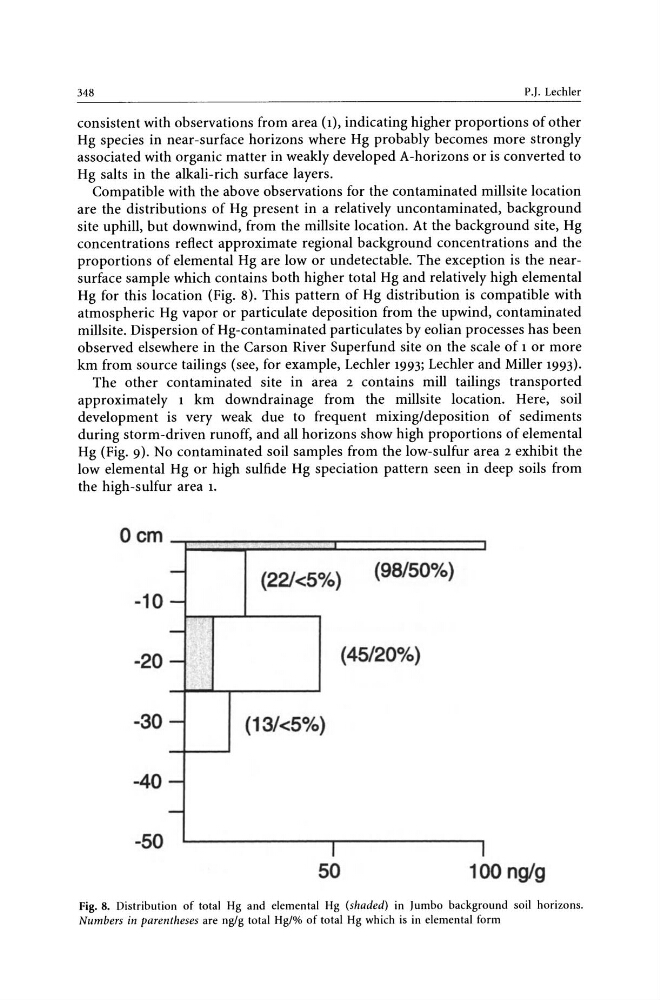
Compatible with the above observations for the contaminated millsite location
are the distributions of Hg present in a relatively uncontaminated, background
site uphill, but downwind, from the millsite location. At the background site, Hg
concentrations reflect approximate regional background concentrations and the
proportions of elemental Hg are low or undetectable. The exception is the nearsurface sample which contains both higher total Hg and relatively high elemental
Hg for this location (Fig. 8). This pattern of Hg distribution is compatible with
atmospheric Hg vapor or particulate deposition from the upwind, contaminated
millsite. Dispersion of Hg-contaminated particulates by eolian processes has been
observed elsewhere in the Carson River Superfund site on the scale of 1 or more
km from source tailings (see, for example, Lechler 1993; Lechler and Miller 1993).
The other contaminated site in area 2 contains mill tailings transported
approximately 1 km downdrainage from the millsite location. Here, soil
development is very weak due to frequent mixing/deposition of sediments
during storm-driven runoff, and all horizons show high proportions of elemental
Hg (Fig. 9). No contaminated soil samples from the low-sulfur area 2 exhibit the
low elemental Hg or high sulfide Hg speciation pattern seen in deep soils from
the high-sulfur area 1.
Oem
-
(221<5%)
(98/500/0)
-10 -
-
-20 -
(45/20%)
-30 -
(13/<50/0)
-40 -
-
-50
I
I
50
100 nglg
Fig. 8. Distribution of total Hg and elemental Hg (shaded) in J umbo background soil horizons.
Numbers in parentheses are ng/g total Hg/% of total Hg which is in elemental form
P.J. Lechler
consistent with observations from area (1), indicating higher proportions of other
Hg species in near-surface horizons where Hg probably becomes more strongly
associated with organic matter in weakly developed A-horizons or is converted to
Hg salts in the alkali-rich surface layers.
Compatible with the above observations for the contaminated millsite location
are the distributions of Hg present in a relatively uncontaminated, background
site uphill, but downwind, from the millsite location. At the background site, Hg
concentrations reflect approximate regional background concentrations and the
proportions of elemental Hg are low or undetectable. The exception is the nearsurface sample which contains both higher total Hg and relatively high elemental
Hg for this location (Fig. 8). This pattern of Hg distribution is compatible with
atmospheric Hg vapor or particulate deposition from the upwind, contaminated
millsite. Dispersion of Hg-contaminated particulates by eolian processes has been
observed elsewhere in the Carson River Superfund site on the scale of 1 or more
km from source tailings (see, for example, Lechler 1993; Lechler and Miller 1993).
The other contaminated site in area 2 contains mill tailings transported
approximately 1 km downdrainage from the millsite location. Here, soil
development is very weak due to frequent mixing/deposition of sediments
during storm-driven runoff, and all horizons show high proportions of elemental
Hg (Fig. 9). No contaminated soil samples from the low-sulfur area 2 exhibit the
low elemental Hg or high sulfide Hg speciation pattern seen in deep soils from
the high-sulfur area 1.
Oem
-
(221<5%)
(98/500/0)
-10 -
-
-20 -
(45/20%)
-30 -
(13/<50/0)
-40 -
-
-50
I
I
50
100 nglg
Fig. 8. Distribution of total Hg and elemental Hg (shaded) in J umbo background soil horizons.
Numbers in parentheses are ng/g total Hg/% of total Hg which is in elemental form