

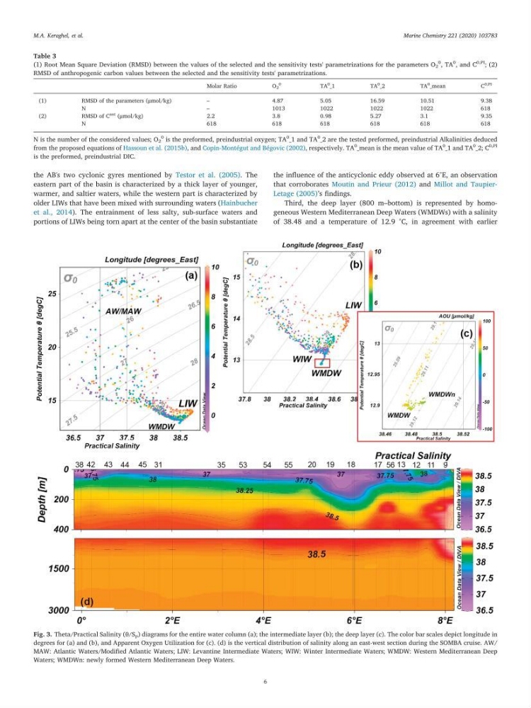
the AB's two cyclonic gyres mentioned by Testor et al. (2005). The
eastern part of the basin is characterized by a thick layer of younger,
warmer, and saltier waters, while the western part is characterized by
older LIWs that have been mixed with surrounding waters (Hainbucher
et al., 2014). The entrainment of less salty, sub-surface waters and
portions of LIWs being torn apart at the center of the basin substantiate
the influence of the anticyclonic eddy observed at 6°E, an observation
that corroborates Moutin and Prieur (2012) and Millot and TaupierLetage (2005)’s findings.
Third, the deep layer (800 m–bottom) is represented by homogeneous Western Mediterranean Deep Waters (WMDWs) with a salinity
of 38.48 and a temperature of 12.9 °C, in agreement with earlier
Table 3
(1) Root Mean Square Deviation (RMSD) between the values of the selected and the sensitivity tests' parametrizations for the parameters O 2
0
, TA
0
, and C
0,PI
; (2)
RMSD of anthropogenic carbon values between the selected and the sensitivity tests' parametrizations.
Molar Ratio
O 2
0
TA
0
_1
TA
0
_2
TA
0 _mean
C
0,PI
(1)
RMSD of the parameters (μmol/kg)
–
4.87
5.05
16.59
10.51
9.38
N
–
1013
1022
1022
1022
618
(2)
RMSD of C
ant (μmol/kg)
2.2
3.8
0.98
5.27
3.1
9.35
N
618
618
618
618
618
618
N is the number of the considered values; O 2
0
is the preformed, preindustrial oxygen; TA
0
_1 and TA
0
_2 are the tested preformed, preindustrial Alkalinities deduced
from the proposed equations of Hassoun et al. (2015b), and Copin-Montégut and Bégovic (2002), respectively. TA
0
_mean is the mean value of TA
0
_1 and TA
0
_2; C
0,PI
is the preformed, preindustrial DIC.
Fig. 3. Theta/Practical Salinity (θ/S p ) diagrams for the entire water column (a); the intermediate layer (b); the deep layer (c). The color bar scales depict longitude in
degrees for (a) and (b), and Apparent Oxygen Utilization for (c). (d) is the vertical distribution of salinity along an east-west section during the SOMBA cruise. AW/
MAW: Atlantic Waters/Modified Atlantic Waters; LIW: Levantine Intermediate Waters; WIW: Winter Intermediate Waters; WMDW: Western Mediterranean Deep
Waters; WMDWn: newly formed Western Mediterranean Deep Waters.
M.A. Keraghel, et al.
Marine Chemistry 221 (2020) 103783
6
eastern part of the basin is characterized by a thick layer of younger,
warmer, and saltier waters, while the western part is characterized by
older LIWs that have been mixed with surrounding waters (Hainbucher
et al., 2014). The entrainment of less salty, sub-surface waters and
portions of LIWs being torn apart at the center of the basin substantiate
the influence of the anticyclonic eddy observed at 6°E, an observation
that corroborates Moutin and Prieur (2012) and Millot and TaupierLetage (2005)’s findings.
Third, the deep layer (800 m–bottom) is represented by homogeneous Western Mediterranean Deep Waters (WMDWs) with a salinity
of 38.48 and a temperature of 12.9 °C, in agreement with earlier
Table 3
(1) Root Mean Square Deviation (RMSD) between the values of the selected and the sensitivity tests' parametrizations for the parameters O 2
0
, TA
0
, and C
0,PI
; (2)
RMSD of anthropogenic carbon values between the selected and the sensitivity tests' parametrizations.
Molar Ratio
O 2
0
TA
0
_1
TA
0
_2
TA
0 _mean
C
0,PI
(1)
RMSD of the parameters (μmol/kg)
–
4.87
5.05
16.59
10.51
9.38
N
–
1013
1022
1022
1022
618
(2)
RMSD of C
ant (μmol/kg)
2.2
3.8
0.98
5.27
3.1
9.35
N
618
618
618
618
618
618
N is the number of the considered values; O 2
0
is the preformed, preindustrial oxygen; TA
0
_1 and TA
0
_2 are the tested preformed, preindustrial Alkalinities deduced
from the proposed equations of Hassoun et al. (2015b), and Copin-Montégut and Bégovic (2002), respectively. TA
0
_mean is the mean value of TA
0
_1 and TA
0
_2; C
0,PI
is the preformed, preindustrial DIC.
Fig. 3. Theta/Practical Salinity (θ/S p ) diagrams for the entire water column (a); the intermediate layer (b); the deep layer (c). The color bar scales depict longitude in
degrees for (a) and (b), and Apparent Oxygen Utilization for (c). (d) is the vertical distribution of salinity along an east-west section during the SOMBA cruise. AW/
MAW: Atlantic Waters/Modified Atlantic Waters; LIW: Levantine Intermediate Waters; WIW: Winter Intermediate Waters; WMDW: Western Mediterranean Deep
Waters; WMDWn: newly formed Western Mediterranean Deep Waters.
M.A. Keraghel, et al.
Marine Chemistry 221 (2020) 103783
6