

Reef Mapping
79
bound frameworks of sticks, with their intersections
corresponding to the location of islands (often marked with
cowrie shells). Other sticks showed the direction of waves
or currents, or an indication of distance or direction to
other islands. Although the stick-maps themselves are not
old, it seems quite likely that such maps could have played
a key role in the navigational feats of the Polynesian
peoples for many centuries.
Detailed mapping of the location of coral reefs
began in the ages of discovery in the West. Since classical
times maps or charts had been widely developed in the
Mediterranean and were often kept by navigators m
coastal pilot books. Travels outside this region began in
the 15th and 16th centuries. Columbus made his first
historic visits to the Caribbean islands in 1492-93, while
Vasco da Gama rounded the Cape of Good Hope and
traveled along the coast of East Africa before crossing to
India just a few years later.
Charts were originally produced by individuals and
later by the large trading companies. Being of high
political and economic value, many of these were kept
as closely guarded secrets. From the early 18th century
onwards, the same charts became the primary responsibility of national hydrographic offices. The representation
of coral reefs on these charts was as a navigational feature
rather than a biological phenomenon, although in many
cases the charts were drawn with at least some knowledge
of the biological and geological setting of coral reefs.
Much of the early scientific knowledge of coral reefs,
from the 18th and 19th centuries, was actually gathered on
the exploratory and hydrographic expeditions setting out
from Western Europe. The voyages of Captain James
Cook in the Pacific and later ones such as those of the
Beagle with Charles Darwin and the Wilkes Exploring
Expedition in the Pacific from 1838 to 1842 led to a great
expansion of knowledge about reefs. Such expeditions
were concerned not only with charting and the expansion
of empires, but with many wider issues of research and
discovery, including natural history and geology.
The first global maps of reefs
The first major global treatise specifically on coral reefs,
which considered both the biological and geological
origins of these, and which included a map showing global
coral reef distribution, was that produced by Charles
Darwin in 1842. While much of what is contained in this
work was the result of Darwin's own observations during
five years on the Beagle, an even larger proportion is
based on his readings of the reports of other such
expeditions and on his discussions with the various ships"
captains and others who took part in these. In his own
words, Darwin's work "is the result of many months'
labour. [He] consulted, as far as [he] was able, every
voyage and map" (Darwin, 1842).
In 1912, the French scientist Joubin published a much
larger-scale global map of coral reefs, covering the world
in five large sheets at a scale of 1:10 000 000. Joubin's
work was based not only on a survey of existing maps
and charts, but also on the results of a much larger
data-gathering e.xercise, which included correspondence
with many interested people throughout the world. (He
includes in his acknowledgement thanks to the abbes
throughout the world who passed his information requests
on to missions in quite a number of countries.)
Until very recently, few other works have made
such systematic attempts to map coral reefs globally. In
general, following on from the early global reviews, there
was a trend towards more detailed studies at the local
Sou din gi Id falhomi.
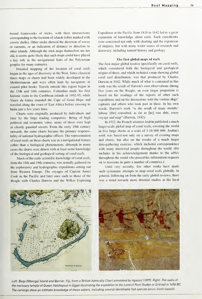
Left: Beqa IMbengal Island and Barrier, Fiji, from a Britist) Admiralty Ctiart annotated by Agassiz 118991. Right: The walls of
the mortuary temple of Queen Hatshepsut in Egypt illustrating the expedition to the Land of Punt (Sudan or Entreal in 1496 BC.
The carvings show an intimate l
79
bound frameworks of sticks, with their intersections
corresponding to the location of islands (often marked with
cowrie shells). Other sticks showed the direction of waves
or currents, or an indication of distance or direction to
other islands. Although the stick-maps themselves are not
old, it seems quite likely that such maps could have played
a key role in the navigational feats of the Polynesian
peoples for many centuries.
Detailed mapping of the location of coral reefs
began in the ages of discovery in the West. Since classical
times maps or charts had been widely developed in the
Mediterranean and were often kept by navigators m
coastal pilot books. Travels outside this region began in
the 15th and 16th centuries. Columbus made his first
historic visits to the Caribbean islands in 1492-93, while
Vasco da Gama rounded the Cape of Good Hope and
traveled along the coast of East Africa before crossing to
India just a few years later.
Charts were originally produced by individuals and
later by the large trading companies. Being of high
political and economic value, many of these were kept
as closely guarded secrets. From the early 18th century
onwards, the same charts became the primary responsibility of national hydrographic offices. The representation
of coral reefs on these charts was as a navigational feature
rather than a biological phenomenon, although in many
cases the charts were drawn with at least some knowledge
of the biological and geological setting of coral reefs.
Much of the early scientific knowledge of coral reefs,
from the 18th and 19th centuries, was actually gathered on
the exploratory and hydrographic expeditions setting out
from Western Europe. The voyages of Captain James
Cook in the Pacific and later ones such as those of the
Beagle with Charles Darwin and the Wilkes Exploring
Expedition in the Pacific from 1838 to 1842 led to a great
expansion of knowledge about reefs. Such expeditions
were concerned not only with charting and the expansion
of empires, but with many wider issues of research and
discovery, including natural history and geology.
The first global maps of reefs
The first major global treatise specifically on coral reefs,
which considered both the biological and geological
origins of these, and which included a map showing global
coral reef distribution, was that produced by Charles
Darwin in 1842. While much of what is contained in this
work was the result of Darwin's own observations during
five years on the Beagle, an even larger proportion is
based on his readings of the reports of other such
expeditions and on his discussions with the various ships"
captains and others who took part in these. In his own
words, Darwin's work "is the result of many months'
labour. [He] consulted, as far as [he] was able, every
voyage and map" (Darwin, 1842).
In 1912, the French scientist Joubin published a much
larger-scale global map of coral reefs, covering the world
in five large sheets at a scale of 1:10 000 000. Joubin's
work was based not only on a survey of existing maps
and charts, but also on the results of a much larger
data-gathering e.xercise, which included correspondence
with many interested people throughout the world. (He
includes in his acknowledgement thanks to the abbes
throughout the world who passed his information requests
on to missions in quite a number of countries.)
Until very recently, few other works have made
such systematic attempts to map coral reefs globally. In
general, following on from the early global reviews, there
was a trend towards more detailed studies at the local
Sou din gi Id falhomi.
Left: Beqa IMbengal Island and Barrier, Fiji, from a Britist) Admiralty Ctiart annotated by Agassiz 118991. Right: The walls of
the mortuary temple of Queen Hatshepsut in Egypt illustrating the expedition to the Land of Punt (Sudan or Entreal in 1496 BC.
The carvings show an intimate l