

78
WORLD ATLAS OF CORAL REEFS
Chapter 3
Reef Mapping
:^»-
Soundings in fathoms.
AS
long as humans and coral reefs have existed
in close proximity, a knowledge of reef distribution
has been important. The earliest navigators in
coastal environments were in particular need of such
information: reefs were a terrible hazard to be avoided, but
also a source of food, while shelter in their calm lagoons
was important during rough weather. This chapter traces
the early development of knowledge on reef distribution,
and subsequently of reef mapping, including the development of the first global maps of coral reefs. It then
reviews the contemporary methods of reef mapping,
including both hydrographic techniques and remote
sensing. A final section looks at the current state of global
reef mapping, centered on the present work.
Historical background
Navigation among coral reefs may be almost as old as
navigation itself. Many early cultures achieved considerable feats of navigation in coral reef regions. In
Egypt, friezes on the walls of the mortuary temple
of Queen Hatshepsut clearly describe a voyage of
considerable distance by boat along the Red Sea. This
famous expedition to the Land of Punt took place in 1496
BC. Navigation in these areas was not solely undertaken
by the Egyptians. The Babylonian and Sumerian empires
traded across the Arabian Gulf and with many island
kingdoms such as Dilmun in present-day Bahrain.
Herodotus reports that Phoenician sailors circumnavigated the entire coast of Africa under orders from
Pharaoh Necho II around 600 BC.
The production of maps in the ancient world,
incorporating the coastlines of the Arabian Gulf and
the Red Sea, can be traced back over 4 000 years, to
Babylonian stone tablets and Egyptian papyrus maps.
Following on from this, the Greeks and Romans developed
more detailed maps, including of the seas around the
Arabian Peninsula.
In the Pacific, the timing of movements and the
directions taken by Pacific islanders are still under debate,
although it has been suggested that Polynesian navigators
may have reached Hawai'i from the Marquesas Islands by
400 AD. Almost every tropical Pacific island had thus been
settled by this date. Such movements indicate phenomenal
navigational skills. Little is known about the existence of
physical tools which might have been utilized to aid their
navigation, but in the 19th century a number of stick-charts
were discovered in the Marshall Islands. These consisted of
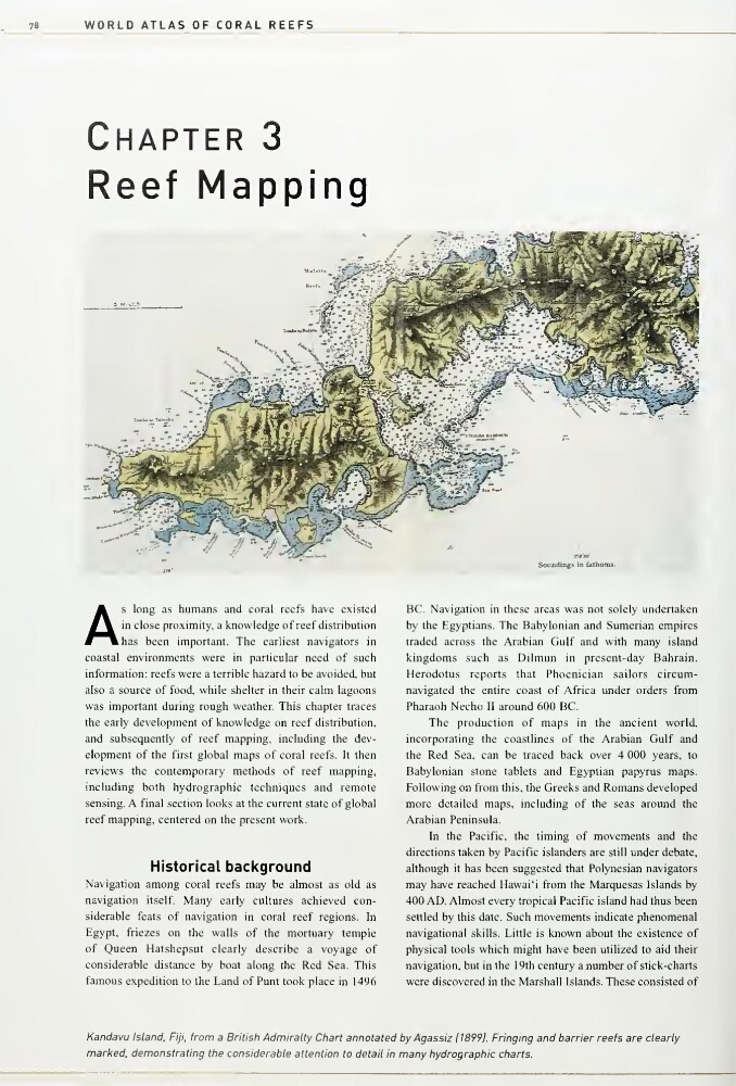
Kandavu Island, Fiji, from a British Admiralty Chart annotated by Agassiz 118991. Fringing and barrier reefs are clearly
nnarked, demonstrating the considerable attention to detail in many hydrographic charts.
WORLD ATLAS OF CORAL REEFS
Chapter 3
Reef Mapping
:^»-
Soundings in fathoms.
AS
long as humans and coral reefs have existed
in close proximity, a knowledge of reef distribution
has been important. The earliest navigators in
coastal environments were in particular need of such
information: reefs were a terrible hazard to be avoided, but
also a source of food, while shelter in their calm lagoons
was important during rough weather. This chapter traces
the early development of knowledge on reef distribution,
and subsequently of reef mapping, including the development of the first global maps of coral reefs. It then
reviews the contemporary methods of reef mapping,
including both hydrographic techniques and remote
sensing. A final section looks at the current state of global
reef mapping, centered on the present work.
Historical background
Navigation among coral reefs may be almost as old as
navigation itself. Many early cultures achieved considerable feats of navigation in coral reef regions. In
Egypt, friezes on the walls of the mortuary temple
of Queen Hatshepsut clearly describe a voyage of
considerable distance by boat along the Red Sea. This
famous expedition to the Land of Punt took place in 1496
BC. Navigation in these areas was not solely undertaken
by the Egyptians. The Babylonian and Sumerian empires
traded across the Arabian Gulf and with many island
kingdoms such as Dilmun in present-day Bahrain.
Herodotus reports that Phoenician sailors circumnavigated the entire coast of Africa under orders from
Pharaoh Necho II around 600 BC.
The production of maps in the ancient world,
incorporating the coastlines of the Arabian Gulf and
the Red Sea, can be traced back over 4 000 years, to
Babylonian stone tablets and Egyptian papyrus maps.
Following on from this, the Greeks and Romans developed
more detailed maps, including of the seas around the
Arabian Peninsula.
In the Pacific, the timing of movements and the
directions taken by Pacific islanders are still under debate,
although it has been suggested that Polynesian navigators
may have reached Hawai'i from the Marquesas Islands by
400 AD. Almost every tropical Pacific island had thus been
settled by this date. Such movements indicate phenomenal
navigational skills. Little is known about the existence of
physical tools which might have been utilized to aid their
navigation, but in the 19th century a number of stick-charts
were discovered in the Marshall Islands. These consisted of
Kandavu Island, Fiji, from a British Admiralty Chart annotated by Agassiz 118991. Fringing and barrier reefs are clearly
nnarked, demonstrating the considerable attention to detail in many hydrographic charts.