

Polynesia
385
French Polynesiap
the Pitcairn Islands and
CUpperton Atoll
MAPS I4f. g and h
French Polynesia represents one of the
largest territories in the Pacific and incorporates
some 6 000 square kilometers of coral reefs. It is
divided into five distinct archipelagos, each following a
chain oriented from northwest to southeast. Four of these
archipelagos trace the movement of the Earth's crust over
volcanic hotspots and their structures are younger in the
southeast, where there are a number of high islands. The
Tuamotu Archipelago in the center of the territory also
originated from volcanic activity, but these volcanoes are
associated with a shallow plateau on the edge of the
spreading East Pacific Ridge.
The Marquesas, a group of high volcanic islands
together with a number of smaller islets and shallow
banks, form the most northerly archipelago. They lie in
the path of the westward flowing South Equatorial Current
and are climatically quite distinct from the other islands,
with very low rainfall showing a peak in June. Their
northerly latitude places them relatively close to the
equator so they are rarely impacted by cyclones. Despite
this, reef development is poor. There are short stretches of
fringing reefs and many less clearly defined structures.
These reefs are very young, and their diversity is low.
The Tuamotus make up the largest and geologically
^Okm
the oldest archipelago. They consist of low coralline
atolls, with the exception of Makatea, which is raised,
reaching some 113 meters above sea level. These atolls
include some of the largest in the Pacific - Fakarava at
1
400 square kilometers and Rangiroa at nearly 1 800
square kilometers, with some 240 islands along its atoll
rim. Taiaro Atoll near the center of the group is slightly
uplifted, with a completely enclosed lagoon. The closure
of this lagoon is thought to have been relatively recent,
and there are some surviving reef communities despite
their apparent isolation and the raised salinities.
The Society Islands are among the best known in the
region. Mehetia in the southeast is an active volcano with
only sparse coral development along its coastline. Tahiti is
the largest island in the country. Like the neighboring
Moorea it is a high volcanic island with vertiginous slopes.
The coastlines of both islands have discontinuous fringing
reefs and are surrounded by offshore barrier reefs, each
broken by numerous passes. To the northwest many of the
islands have similar structures with high central islands
and barrier reefs; however, Maupiti is a near-atoll, and the
remaining structures to the northwest are true atolls.
The Gambler Islands lie at the southeastern end of the
Tuamotus. and are sometimes considered as part of this
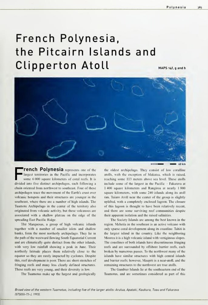
Broad view of the western Tuamotus, including five of the larger atolls: Arutua, Apataki, Kaukura. Toau and Fakarava
15TS055-73-J. 19931.
385
French Polynesiap
the Pitcairn Islands and
CUpperton Atoll
MAPS I4f. g and h
French Polynesia represents one of the
largest territories in the Pacific and incorporates
some 6 000 square kilometers of coral reefs. It is
divided into five distinct archipelagos, each following a
chain oriented from northwest to southeast. Four of these
archipelagos trace the movement of the Earth's crust over
volcanic hotspots and their structures are younger in the
southeast, where there are a number of high islands. The
Tuamotu Archipelago in the center of the territory also
originated from volcanic activity, but these volcanoes are
associated with a shallow plateau on the edge of the
spreading East Pacific Ridge.
The Marquesas, a group of high volcanic islands
together with a number of smaller islets and shallow
banks, form the most northerly archipelago. They lie in
the path of the westward flowing South Equatorial Current
and are climatically quite distinct from the other islands,
with very low rainfall showing a peak in June. Their
northerly latitude places them relatively close to the
equator so they are rarely impacted by cyclones. Despite
this, reef development is poor. There are short stretches of
fringing reefs and many less clearly defined structures.
These reefs are very young, and their diversity is low.
The Tuamotus make up the largest and geologically
^Okm
the oldest archipelago. They consist of low coralline
atolls, with the exception of Makatea, which is raised,
reaching some 113 meters above sea level. These atolls
include some of the largest in the Pacific - Fakarava at
1
400 square kilometers and Rangiroa at nearly 1 800
square kilometers, with some 240 islands along its atoll
rim. Taiaro Atoll near the center of the group is slightly
uplifted, with a completely enclosed lagoon. The closure
of this lagoon is thought to have been relatively recent,
and there are some surviving reef communities despite
their apparent isolation and the raised salinities.
The Society Islands are among the best known in the
region. Mehetia in the southeast is an active volcano with
only sparse coral development along its coastline. Tahiti is
the largest island in the country. Like the neighboring
Moorea it is a high volcanic island with vertiginous slopes.
The coastlines of both islands have discontinuous fringing
reefs and are surrounded by offshore barrier reefs, each
broken by numerous passes. To the northwest many of the
islands have similar structures with high central islands
and barrier reefs; however, Maupiti is a near-atoll, and the
remaining structures to the northwest are true atolls.
The Gambler Islands lie at the southeastern end of the
Tuamotus. and are sometimes considered as part of this
Broad view of the western Tuamotus, including five of the larger atolls: Arutua, Apataki, Kaukura. Toau and Fakarava
15TS055-73-J. 19931.