

384
WORLD ATLAS OF CORAL REEFS
Protected areas wi th coral reefs
t Site name
9
Designation
Abbreviation
lUCN cal.
Size (kmil
Year,
Cook Islands
Aitutaki
Hunting Reserve
HR
na
na
1981
Manuae Lagoon
Hunting Reserve
HR
na
na
na
Palmerston Lagoon
Hunting Reserve
HR
na
na
na
Suwarrow Atoll
National Park
NP
IV
1.60
1978
The biodiversity of Cook Island reefs has not received a
great deal of attention, however it is clear that they lie at some
distance from the mega-diverse areas of the Western Pacific.
A natural heritage project is developing a database of
species, and currently includes 578 fish species (of which
491 are shallow water or benthic species), 1 16 stony corals
(excluding solitary species), 390 molluscs, 100 crustaceans
and 50 echinoderms (including 20 sea cucumbers). It has
been suggested that the diversity and abundance of species is
greatest around the high (volcanic) islands and lowest around
the uplifted (inakaiea) islands. The Cook Islands lie east of
the natural distribution of mangroves and none are recorded.
Politically the Cook Islands are an internally selfgoverning state in free association with New Zealand. Like
Niueans, Cook Islanders have New Zealand citizenship, and
a large majority live in New Zealand. The remaining
population is relatively small, probably far smaller than preEuropean levels, with about half of the people living on
Rarotonga. Utilization of, and reliance on, coral reef
resources is considerable. In 1 996 about 70 percent of all
households undertook at least some form of subsistence
fishing, including both gleaning from reef flats and boatbased fishing. Marine resources are also extensively used in
exports, with large black pearl farms in Manihiki Atoll
providing the main source of export income. There are also
minor export industries associated with trochus and
ornamental fish. Tourism is an important industry for the
Cook Islands, which receive about 100 000 visitors per year.
Snorkelling and diving are popular activities.
There are some human impacts on the reefs, particularly
associated with urban and agricultural development.
Sedimentation, chemical and nutrient pollution are all
potential threats. Surveys of flinging reefs in the vicinity of
the township area of Rarotonga in 1999 suggested that
benthic cover of algal turf had increased by 20 percent to
90 percent, and that there had been decreases in diversity
in some fish families over the previous five years. Such
observations are probably linked to increased stress from
urban development. Foreshore development has been poorly
planned in a number of areas and is causing coastal erosion.
There were reports of a crown-of-thoms starfish outbreak in
1998 on Rarotonga and Aitutaki. A mass bleaching event
was also recorded in March 2000 with bleaching observed in
up to 80 percent of corals. Sea-level rise associated with
climate change could present significant problems for a
number of the low-lying islands and associated reefs.
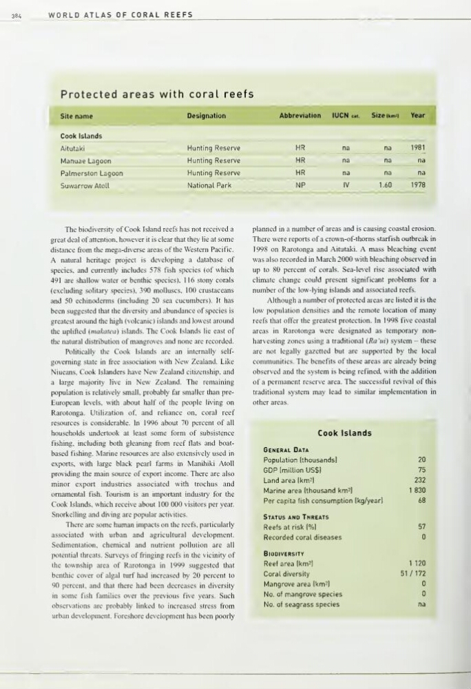
Although a number of protected areas are listed it is the
low population densities and the remote location of many
reefs that offer the greatest protection. In 1998 five coastal
areas in Rarotonga were designated as temporary nonharvesting zones using a traditional (Rani) system - these
are not legally gazetted but are supported by the local
communities. The benefits of these areas are already being
observed and the system is being refined, with the addition
of a permanent reserve area. The successful revival of this
traditional system may lead to similar implementation in
other areas.
Cook Isl ands
General Data
Population (thousands)
20
GDP Imllllon US$)
75
Land area (km^l
232
Marine area Ithousand km^j
1 830
Per capita fish consumption (kg/year)
68
Status and Threats
Reefs at risk (%l
57
Recorded coral diseases
Biodiversity
Reef area Ikm^l
1
120
Coral diversity
51 /172
Mangrove area |km2|
No. of mangrove species
No. of seagrass species
na
WORLD ATLAS OF CORAL REEFS
Protected areas wi th coral reefs
t Site name
9
Designation
Abbreviation
lUCN cal.
Size (kmil
Year,
Cook Islands
Aitutaki
Hunting Reserve
HR
na
na
1981
Manuae Lagoon
Hunting Reserve
HR
na
na
na
Palmerston Lagoon
Hunting Reserve
HR
na
na
na
Suwarrow Atoll
National Park
NP
IV
1.60
1978
The biodiversity of Cook Island reefs has not received a
great deal of attention, however it is clear that they lie at some
distance from the mega-diverse areas of the Western Pacific.
A natural heritage project is developing a database of
species, and currently includes 578 fish species (of which
491 are shallow water or benthic species), 1 16 stony corals
(excluding solitary species), 390 molluscs, 100 crustaceans
and 50 echinoderms (including 20 sea cucumbers). It has
been suggested that the diversity and abundance of species is
greatest around the high (volcanic) islands and lowest around
the uplifted (inakaiea) islands. The Cook Islands lie east of
the natural distribution of mangroves and none are recorded.
Politically the Cook Islands are an internally selfgoverning state in free association with New Zealand. Like
Niueans, Cook Islanders have New Zealand citizenship, and
a large majority live in New Zealand. The remaining
population is relatively small, probably far smaller than preEuropean levels, with about half of the people living on
Rarotonga. Utilization of, and reliance on, coral reef
resources is considerable. In 1 996 about 70 percent of all
households undertook at least some form of subsistence
fishing, including both gleaning from reef flats and boatbased fishing. Marine resources are also extensively used in
exports, with large black pearl farms in Manihiki Atoll
providing the main source of export income. There are also
minor export industries associated with trochus and
ornamental fish. Tourism is an important industry for the
Cook Islands, which receive about 100 000 visitors per year.
Snorkelling and diving are popular activities.
There are some human impacts on the reefs, particularly
associated with urban and agricultural development.
Sedimentation, chemical and nutrient pollution are all
potential threats. Surveys of flinging reefs in the vicinity of
the township area of Rarotonga in 1999 suggested that
benthic cover of algal turf had increased by 20 percent to
90 percent, and that there had been decreases in diversity
in some fish families over the previous five years. Such
observations are probably linked to increased stress from
urban development. Foreshore development has been poorly
planned in a number of areas and is causing coastal erosion.
There were reports of a crown-of-thoms starfish outbreak in
1998 on Rarotonga and Aitutaki. A mass bleaching event
was also recorded in March 2000 with bleaching observed in
up to 80 percent of corals. Sea-level rise associated with
climate change could present significant problems for a
number of the low-lying islands and associated reefs.
Although a number of protected areas are listed it is the
low population densities and the remote location of many
reefs that offer the greatest protection. In 1998 five coastal
areas in Rarotonga were designated as temporary nonharvesting zones using a traditional (Rani) system - these
are not legally gazetted but are supported by the local
communities. The benefits of these areas are already being
observed and the system is being refined, with the addition
of a permanent reserve area. The successful revival of this
traditional system may lead to similar implementation in
other areas.
Cook Isl ands
General Data
Population (thousands)
20
GDP Imllllon US$)
75
Land area (km^l
232
Marine area Ithousand km^j
1 830
Per capita fish consumption (kg/year)
68
Status and Threats
Reefs at risk (%l
57
Recorded coral diseases
Biodiversity
Reef area Ikm^l
1
120
Coral diversity
51 /172
Mangrove area |km2|
No. of mangrove species
No. of seagrass species
na