

Micronesia
363
Kiribati and Nauru
MAPS 13e and f
15 km
KiriDStI S islands and coral reefs straddle a
vast swathe of the Pacific Ocean but consist of
only some 33 islands or island systeins. These are
typically divided into three broad groups. Most of the
actual islands are now referred to by their Micronesian
names, although the island groups are still largely referred
to by their European names. In the far west is the long
disparate chain of the Gilbert Islands or Tungaru group -
this is a chain of 1 1 atolls and five other islands which
have no lagoon but are of similar origin. Often considered
alongside this chain is the isolated island of Banaba, a
raised atoll reaching a height of some 81 meters similar to
Nauru (see below), and the only "high" island in the
country. The Phoenix Islands include three atolls and
five other islands with fringing reefs. There are also at
least two other submerged reef structures (Winslow and
Carondelet) which have no associated islands. The Line
Islands in the east fall into a northern and southern group.
The northern group includes the island of Teraina and the
atolls of Tabuaeran and Kiritimati. The latter, pronounced
Kirisimas and also known as Christmas Island, has a
largely infilled lagoon and the largest land area of any
atoll. The southern Line Islands are mostly uninhabited
and include the atoll of Milleimium Island (formerly
Caroline Island) and three other islands with fringing
reefs as well as at least one other submerged reef with no
associated island. Lying on the equator, the country is
largely unaffected by cyclones. The predominant climatic
influence comes from the southeast trade winds which
create a pronounced windward side to the reefs. The
western islands are generally wetter, while the Line
Islands lie in the dry equatorial zone. Rainfall is also
significantly higher in all areas during El Nifio Southern
Oscillation events. Although tidal ranges tend to be low
(less than 2 meters at spring tides) there is variation in
sea level through the year (10-20 centimeters variation in
mean monthly levels) which can be further exacerbated by
up to 40 centimeters during El Niiio years.
The atolls comprise a typical diversity of habitats,
including channels, lagoon reefs and shallow reef flats as
well as reef slope environments. There is a clear difference
between windward and leeward sides, with the windward
(eastern) sides typically having a continuous reef margin,
narrow reef flat and well developed islands. The leeward
reefs are typically much wider, but in some places show a
more gradual slope with a less developed reef flat, often
submerged at low tide. Spur and groove formations are on
all sides, but are usually best developed on lee shores.
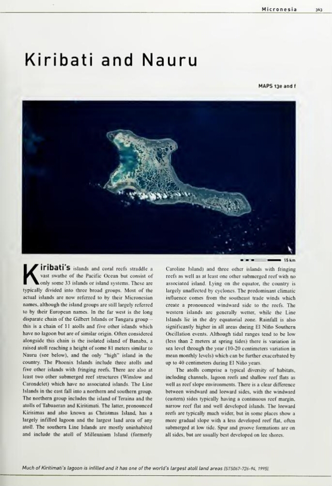
Much of Kiritimati's lagoon is infilled and it has one of the world's largest atoll land areas ISTS067-726-94, 19951.
363
Kiribati and Nauru
MAPS 13e and f
15 km
KiriDStI S islands and coral reefs straddle a
vast swathe of the Pacific Ocean but consist of
only some 33 islands or island systeins. These are
typically divided into three broad groups. Most of the
actual islands are now referred to by their Micronesian
names, although the island groups are still largely referred
to by their European names. In the far west is the long
disparate chain of the Gilbert Islands or Tungaru group -
this is a chain of 1 1 atolls and five other islands which
have no lagoon but are of similar origin. Often considered
alongside this chain is the isolated island of Banaba, a
raised atoll reaching a height of some 81 meters similar to
Nauru (see below), and the only "high" island in the
country. The Phoenix Islands include three atolls and
five other islands with fringing reefs. There are also at
least two other submerged reef structures (Winslow and
Carondelet) which have no associated islands. The Line
Islands in the east fall into a northern and southern group.
The northern group includes the island of Teraina and the
atolls of Tabuaeran and Kiritimati. The latter, pronounced
Kirisimas and also known as Christmas Island, has a
largely infilled lagoon and the largest land area of any
atoll. The southern Line Islands are mostly uninhabited
and include the atoll of Milleimium Island (formerly
Caroline Island) and three other islands with fringing
reefs as well as at least one other submerged reef with no
associated island. Lying on the equator, the country is
largely unaffected by cyclones. The predominant climatic
influence comes from the southeast trade winds which
create a pronounced windward side to the reefs. The
western islands are generally wetter, while the Line
Islands lie in the dry equatorial zone. Rainfall is also
significantly higher in all areas during El Nifio Southern
Oscillation events. Although tidal ranges tend to be low
(less than 2 meters at spring tides) there is variation in
sea level through the year (10-20 centimeters variation in
mean monthly levels) which can be further exacerbated by
up to 40 centimeters during El Niiio years.
The atolls comprise a typical diversity of habitats,
including channels, lagoon reefs and shallow reef flats as
well as reef slope environments. There is a clear difference
between windward and leeward sides, with the windward
(eastern) sides typically having a continuous reef margin,
narrow reef flat and well developed islands. The leeward
reefs are typically much wider, but in some places show a
more gradual slope with a less developed reef flat, often
submerged at low tide. Spur and groove formations are on
all sides, but are usually best developed on lee shores.
Much of Kiritimati's lagoon is infilled and it has one of the world's largest atoll land areas ISTS067-726-94, 19951.