

364
WORLD ATLAS OF CORAL REEFS
Given the wide geographic spread of this country it is
possible to follow some of the wider regional trends within
the country itself, notably the diminishing species diversity
moving from west to east. Some 1 1 5 hard coral species have
been recorded from Tarawa and Abaiang Atolls in the west,
while Tabuaeran in the east has 71. Blue coral Heliopora
coerulea is reported to be widespread in the west despite
being uncommon over nearby areas in the Pacific. Coral
cover on the outer reef slopes is typically very high, with
measurements on Tarawa and Abaiang of up to 57 percent
cover at 3 meters depth and 28-72 percent at 10 meters.
Much of the remainder of the benthos is dominated by
coralline algae. There are several very important seabird
nesting colonies in the Phoenix and Line Islands, with many
millions of birds, including the Phoeni.x petrel and the
Polynesian storm-petrel.
In addition to the islands mentioned above, a number of
the US Pacific Territories are geographically part of the
Kiribati island groups. Baker and Howland Islands lie to the
north of the Phoenix Islands, while Jarvis, Kingman and
Palmyra lie in the northern Line Islands. Further information
about these islands is given m Chapter 14.
The population of Kiribati is low and almost entirely
concentrated in the Gilbert Islands. Elsewhere most of the
islands are uninhabited, in many areas because freshwater
is not always available. Most of the islanders are heavily
dependent on fish as a source of protein, and overfishing
is a localized problem near population centers. Reports of
increasing incidence of ciguatera poisoning have been
linked to other environmental disturbance including the
dredging of channels and construction of causeways,
although these links remain unproven. Locally, notably in
the Tarawa lagoon, sewage pollution may be a problem. This
has been exacerbated by the construction of causeways in
this atoll to link the islands, which has altered circulation
patterns in the lagoon and interrupted the migration patterns
of spawning fish. Solid waste disposal is a problem in all
areas. Despite being low, populations are now rapidly
increasing and there are moves to settle some of the
uninhabited islands in the Phoenix group.
Milkfish are raised locally in natural ponds in some
areas and there is a significant industry in the cultivation of
Eucheuma algae for export. The possible introduction and
cultivation of non-native species is under consideration,
although this could have serious implications for the wider
environment. Tourism, still at low levels, is increasing.
About 4 000 visitors to Kiribati were recorded in 1995.
Phosphate mining has occurred on a number of the
islands. This has had a major impact on the terrestrial
vegetation, but the effects on coral reefs have been slight,
mostly linked to physical damage by access boats during
the mining process. Kiritimati (Christmas) and Maiden
Islands were the location for hydrogen bomb tests by the
British and US military in the 1950s and 1960s. While these
have had serious medical implications for servicemen there
have been no detailed observations concerning the impacts
on the natural environment - most of the bombs were
exploded in the air some 8-25 kilometers fi-om the islands.
Impacts on the reefs were never assessed. As with other low
islands in the Pacific, perhaps the greatest threat is that of
sea-level rise as a result of climate change.
Despite this list of threats, the majority of the reefs in
this coral reef nation are in excellent condition. A number of
protected areas have been established. Although they do not
incorporate significant marine elements, they do ensure that
wider ecosystems are not disturbed. The Fisheries Division
intends to establish at least one protected area in each island
where fishing is prohibited, as well as seasonally closed
areas to protect spawning stocks.
Nauru
Nauru is a single island country lying in considerable
isolation to the west of Kiribati. Geologically it is a raised
coral atoll reaching a maximum height of 71 meters. The
total depth of limestone is some 500 meters over a basalt
seamount. The edge of the island has a coastal terrace up
to 400 meters wide, perhaps indicating a former sea-level
reef Surrounding the island is a continuous fringing reef
with a reef flat up to 300 meters wide. The biodiversity of
the reefs has not been extensively surveyed, but the coral
fauna is not considered highly diverse. No seagrasses and
only one species of mangrove have been recorded.
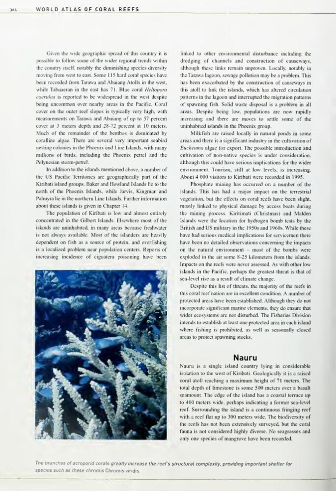
The branches of acropond corals greatly increase the reef's structural complexity, providing important shelter for
species such as these chromis Chromis viridis.
WORLD ATLAS OF CORAL REEFS
Given the wide geographic spread of this country it is
possible to follow some of the wider regional trends within
the country itself, notably the diminishing species diversity
moving from west to east. Some 1 1 5 hard coral species have
been recorded from Tarawa and Abaiang Atolls in the west,
while Tabuaeran in the east has 71. Blue coral Heliopora
coerulea is reported to be widespread in the west despite
being uncommon over nearby areas in the Pacific. Coral
cover on the outer reef slopes is typically very high, with
measurements on Tarawa and Abaiang of up to 57 percent
cover at 3 meters depth and 28-72 percent at 10 meters.
Much of the remainder of the benthos is dominated by
coralline algae. There are several very important seabird
nesting colonies in the Phoenix and Line Islands, with many
millions of birds, including the Phoeni.x petrel and the
Polynesian storm-petrel.
In addition to the islands mentioned above, a number of
the US Pacific Territories are geographically part of the
Kiribati island groups. Baker and Howland Islands lie to the
north of the Phoenix Islands, while Jarvis, Kingman and
Palmyra lie in the northern Line Islands. Further information
about these islands is given m Chapter 14.
The population of Kiribati is low and almost entirely
concentrated in the Gilbert Islands. Elsewhere most of the
islands are uninhabited, in many areas because freshwater
is not always available. Most of the islanders are heavily
dependent on fish as a source of protein, and overfishing
is a localized problem near population centers. Reports of
increasing incidence of ciguatera poisoning have been
linked to other environmental disturbance including the
dredging of channels and construction of causeways,
although these links remain unproven. Locally, notably in
the Tarawa lagoon, sewage pollution may be a problem. This
has been exacerbated by the construction of causeways in
this atoll to link the islands, which has altered circulation
patterns in the lagoon and interrupted the migration patterns
of spawning fish. Solid waste disposal is a problem in all
areas. Despite being low, populations are now rapidly
increasing and there are moves to settle some of the
uninhabited islands in the Phoenix group.
Milkfish are raised locally in natural ponds in some
areas and there is a significant industry in the cultivation of
Eucheuma algae for export. The possible introduction and
cultivation of non-native species is under consideration,
although this could have serious implications for the wider
environment. Tourism, still at low levels, is increasing.
About 4 000 visitors to Kiribati were recorded in 1995.
Phosphate mining has occurred on a number of the
islands. This has had a major impact on the terrestrial
vegetation, but the effects on coral reefs have been slight,
mostly linked to physical damage by access boats during
the mining process. Kiritimati (Christmas) and Maiden
Islands were the location for hydrogen bomb tests by the
British and US military in the 1950s and 1960s. While these
have had serious medical implications for servicemen there
have been no detailed observations concerning the impacts
on the natural environment - most of the bombs were
exploded in the air some 8-25 kilometers fi-om the islands.
Impacts on the reefs were never assessed. As with other low
islands in the Pacific, perhaps the greatest threat is that of
sea-level rise as a result of climate change.
Despite this list of threats, the majority of the reefs in
this coral reef nation are in excellent condition. A number of
protected areas have been established. Although they do not
incorporate significant marine elements, they do ensure that
wider ecosystems are not disturbed. The Fisheries Division
intends to establish at least one protected area in each island
where fishing is prohibited, as well as seasonally closed
areas to protect spawning stocks.
Nauru
Nauru is a single island country lying in considerable
isolation to the west of Kiribati. Geologically it is a raised
coral atoll reaching a maximum height of 71 meters. The
total depth of limestone is some 500 meters over a basalt
seamount. The edge of the island has a coastal terrace up
to 400 meters wide, perhaps indicating a former sea-level
reef Surrounding the island is a continuous fringing reef
with a reef flat up to 300 meters wide. The biodiversity of
the reefs has not been extensively surveyed, but the coral
fauna is not considered highly diverse. No seagrasses and
only one species of mangrove have been recorded.
The branches of acropond corals greatly increase the reef's structural complexity, providing important shelter for
species such as these chromis Chromis viridis.