

Southeast Asia
277
particular interest because of the development of faros,
circular atoll-like structures otherwise largely associated
with the Maldives (Chapter 8). TheTogian Islands, located
in the mouth of Tomini Bay in northern Sulawesi, lie in
very deep water and boast a number of interesting reef
formations including fringing, barrier and atoll reefs. The
reefs of the Tomini Bay are some of the most biodiverse in
the world, with an estimated 77 species of Acropora alone.
The 1998 bleaching event appears to have had relatively
little impact over much of this region, and little or no
bleaching was recorded north and west of Sulawesi.
There is little detailed information describing the reef
communities of the Nusa Tenggara Islands, but fringing
reefs are again widespread. Studies of Lembata Island in
the center of the group show significant variation around
the coastline. The northwest fringing reef is well developed
with a 200-400 meter wide reef flat rich in seagrasses; this
reef flat is even wider on the west coast. By contrast, the
south coast has a narrower reef flat, which is fully exposed
to Indian Ocean swell and may be further affected by
cool water upwellings - a pronounced spur and groove
structure is again noted, and a number of deep water
species are found which may prefer cooler waters. North
of these islands well developed barrier reefs are reported
to occur northwest of Sumbawa and north of Flores. At the
southern end of the Makassar Strait and in the Flores Sea
there are a number of atolls, including the largest in the
country: Kalukalukuang, Sabalana and Taka Bone Rate,
each over 60 kilometers in length with complex atoll rims
formed from individual patch reef structures separated by
narrow and deep channels. In the western end of the
Banda Sea there are, additionally, many smaller atolls.
The Moluccas and Irian Jaya
This final region, dominated by the coastline of Irian Jaya,
also includes the complex island groups of the Moluccas to
the west of Irian Jaya and a chain of small archipelagos
along the south of the Banda Sea, stretching from Timor in
the west to the Aru Islands in the east close to Irian Jaya.
Overall this is another region of relatively complex
bathymetry. Its waters are very deep, and even islands only
a few tens of kilometers apart might be separated by depths
of over 1 000 meters. The only areas of relatively extensive
shallow water and true continental shelf are a platform
west of the Bird's Head (Doberai) Peninsula and the wide
expanse of the Arafura Sea, south of Irian Jaya and east of
the Aru Islands. The latter largely lies above 100 meters in
depth and is quite turbid, in marked contrast to the clear
oceanic waters of much of the rest of the region. The
coastline of Irian Jaya remains very poorly described.
Large areas are low-lying and there is considerable riverine
input, particularly along the south coast. The Bird's Head
Peninsula is more mountainous.
During the Northeast Monsoon, northwesterly winds
cut across most of the region, while during the Southeast
Monsoon southeasterly winds come up towards southern
Irian Jaya and the southern Moluccas, but these are
deflected to become westerly in the more northern areas.
Surface currents are somewhat mixed in this region.
However, a northward current flows between Irian Jaya
and Halmahera and an eastward current flows along the
north shore of Irian Jaya during the Northeast Monsoon.
This pattern reverses during the Southeast Monsoon.
Along the southeast coast of Irian Jaya wide areas are
unsuitable for reef development: this coastline includes
some of the largest mangrove forests in the world - those
off the central coast and in Bintuni Bay may rival the area
occupied by the Sundarbans forest between India and
Bangladesh. There are reported to be fringing reefs along
much of the higher coastal areas to the west. There is little
or no information describing the reef communities around
Bird's Head Peninsula. Along the rest of the north coast
there are fringing reefs on all islands in Cendrawasih Bay,
however the central and eastern coasts of this bay are
dominated by mangrove forests and wide mudflats, and
fringing reef systems have not developed. Further east,
fringing reefs are believed to follow a large proportion of the
coastline between Sarmi and the border with Papua New
Guinea. For the most part these are poorly described, but
reef flats are estimated to reach 300-400 meters wide in
places. Further offshore, north of Irian Jaya, and also east of
Halmahera, there are several small atolls. Off the east coast
of the Aru islands there are vast fringing reefs, with shallow
reef flats extending up to 15 kilometers from the coast.
*
'"'
1
vl..
M=i3M 110km
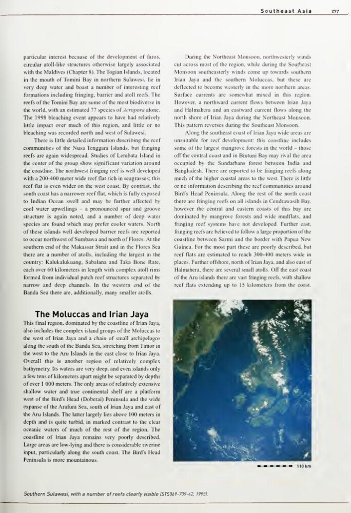
Southern Sulawesi, with a number of reefs clearly visible IST5069-709-42, 19951.
277
particular interest because of the development of faros,
circular atoll-like structures otherwise largely associated
with the Maldives (Chapter 8). TheTogian Islands, located
in the mouth of Tomini Bay in northern Sulawesi, lie in
very deep water and boast a number of interesting reef
formations including fringing, barrier and atoll reefs. The
reefs of the Tomini Bay are some of the most biodiverse in
the world, with an estimated 77 species of Acropora alone.
The 1998 bleaching event appears to have had relatively
little impact over much of this region, and little or no
bleaching was recorded north and west of Sulawesi.
There is little detailed information describing the reef
communities of the Nusa Tenggara Islands, but fringing
reefs are again widespread. Studies of Lembata Island in
the center of the group show significant variation around
the coastline. The northwest fringing reef is well developed
with a 200-400 meter wide reef flat rich in seagrasses; this
reef flat is even wider on the west coast. By contrast, the
south coast has a narrower reef flat, which is fully exposed
to Indian Ocean swell and may be further affected by
cool water upwellings - a pronounced spur and groove
structure is again noted, and a number of deep water
species are found which may prefer cooler waters. North
of these islands well developed barrier reefs are reported
to occur northwest of Sumbawa and north of Flores. At the
southern end of the Makassar Strait and in the Flores Sea
there are a number of atolls, including the largest in the
country: Kalukalukuang, Sabalana and Taka Bone Rate,
each over 60 kilometers in length with complex atoll rims
formed from individual patch reef structures separated by
narrow and deep channels. In the western end of the
Banda Sea there are, additionally, many smaller atolls.
The Moluccas and Irian Jaya
This final region, dominated by the coastline of Irian Jaya,
also includes the complex island groups of the Moluccas to
the west of Irian Jaya and a chain of small archipelagos
along the south of the Banda Sea, stretching from Timor in
the west to the Aru Islands in the east close to Irian Jaya.
Overall this is another region of relatively complex
bathymetry. Its waters are very deep, and even islands only
a few tens of kilometers apart might be separated by depths
of over 1 000 meters. The only areas of relatively extensive
shallow water and true continental shelf are a platform
west of the Bird's Head (Doberai) Peninsula and the wide
expanse of the Arafura Sea, south of Irian Jaya and east of
the Aru Islands. The latter largely lies above 100 meters in
depth and is quite turbid, in marked contrast to the clear
oceanic waters of much of the rest of the region. The
coastline of Irian Jaya remains very poorly described.
Large areas are low-lying and there is considerable riverine
input, particularly along the south coast. The Bird's Head
Peninsula is more mountainous.
During the Northeast Monsoon, northwesterly winds
cut across most of the region, while during the Southeast
Monsoon southeasterly winds come up towards southern
Irian Jaya and the southern Moluccas, but these are
deflected to become westerly in the more northern areas.
Surface currents are somewhat mixed in this region.
However, a northward current flows between Irian Jaya
and Halmahera and an eastward current flows along the
north shore of Irian Jaya during the Northeast Monsoon.
This pattern reverses during the Southeast Monsoon.
Along the southeast coast of Irian Jaya wide areas are
unsuitable for reef development: this coastline includes
some of the largest mangrove forests in the world - those
off the central coast and in Bintuni Bay may rival the area
occupied by the Sundarbans forest between India and
Bangladesh. There are reported to be fringing reefs along
much of the higher coastal areas to the west. There is little
or no information describing the reef communities around
Bird's Head Peninsula. Along the rest of the north coast
there are fringing reefs on all islands in Cendrawasih Bay,
however the central and eastern coasts of this bay are
dominated by mangrove forests and wide mudflats, and
fringing reef systems have not developed. Further east,
fringing reefs are believed to follow a large proportion of the
coastline between Sarmi and the border with Papua New
Guinea. For the most part these are poorly described, but
reef flats are estimated to reach 300-400 meters wide in
places. Further offshore, north of Irian Jaya, and also east of
Halmahera, there are several small atolls. Off the east coast
of the Aru islands there are vast fringing reefs, with shallow
reef flats extending up to 15 kilometers from the coast.
*
'"'
1
vl..
M=i3M 110km
Southern Sulawesi, with a number of reefs clearly visible IST5069-709-42, 19951.