

Western Indian Ocean
185
1^
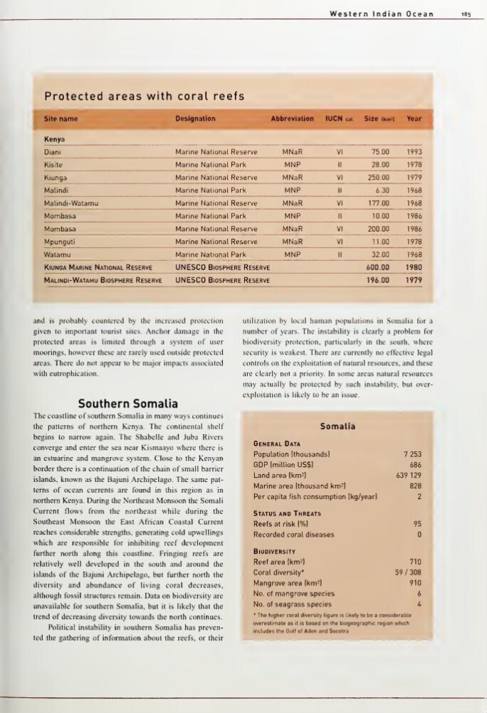
Protected areas with coral reefs
f
Site name
Designation
,Abbreviation
lUCN cal.
Size ikm'l
1
Year
i
Kenya
Diani
Marine National Reserve
MNaR
VI
75.00
1993
Kisite
Marine National Park
MNP
II
28.00
1978
Kiunga
Marine National Reserve
MNaR
VI
250.00
1979
Malindi
'
Marine National Park
MNP
II
6.30
1968
Malindi-Watamu
Marine National Reserve
MNaR
VI
177.00
1968
Mombasa
Marine National Park
MNP
II
10.00
1986
Mombasa
Marine National Reserve
MNaR
VI
200.00
1986
Mpunguti
Marine National Reserve
MNaR
VI
11.00
1978
Watamu
Marine National Park
MNP
II
32.00
1968
Kiunga Marine National Reserve
UNESCO Biosphere Reserve
600.00
1980
Malindi-Watamu Bi OSPHERE Reserve
UNESCO Biosphere Reserve
196.00
1979
and is probably countered by the increased protection
given to important tourist sites. Anchor damage in the
protected areas is limited through a system of user
moorings, however these are rarely used outside protected
areas. There do not appear to be major impacts associated
with eutrophication.
Southern Somalia
The coastline of southern Somalia in many ways continues
the patterns of northern Kenya. The continental shelf
begins to narrow again. The Shabelle and Juba Rivers
converge and enter the sea near Kismaayo where there is
an estuarine and mangrove system. Close to the Kenyan
border there is a continuation of the chain of small barrier
islands, known as the Bajuni Archipelago. The same patterns of ocean currents are found in this region as in
northern Kenya. During the Northeast Monsoon the Somali
Current flows from the northeast while during the
Southeast Monsoon the East African Coastal Current
reaches considerable strengths, generating cold upwellings
which are responsible for inhibiting reef development
further north along this coastline. Fringing reefs are
relatively well developed in the south and around the
islands of the Bajuni Archipelago, but further north the
diversity and abundance of living coral decreases,
although fossil structures remain. Data on biodiversity are
unavailable for southern Somalia, but it is likely that the
trend of decreasing diversity towards the north continues.
Political instability in southern Somalia has prevented the gathering of information about the reefs, or their
utilization by local human populations in Somalia for a
number of years. The instability is clearly a problem for
biodiversity protection, particularly in the south, where
security is weakest. There are currently no effective legal
controls on the exploitation of natural resources, and these
are clearly not a priority. In some areas natural resources
may actually be protected by such instability, but overexploitation is likely to be an issue.
^^^^^
Somal ia
General Data
Population Ithousandsl
7 253
GDP [million US$1
686
Land area (km'l
639 129
Marine area (thousand km^l
828
Per capita fish consumption (kg/year)
2
Status and Threats
Reefs at risk l%l
95
Recorded coral diseases
Biodiversity
Reef area (km^l
710
Coral diversity*
59/308
Mangrove area jkm^l
910
No. of mangrove species
6
No. of seagrass species
4
• The higher coral diversity figure is 1ikely to be a considerable
overestimate as it is based on the biogeog raphic regi on whrch
includes the Gulf of Aden and Socotra
185
1^
Protected areas with coral reefs
f
Site name
Designation
,Abbreviation
lUCN cal.
Size ikm'l
1
Year
i
Kenya
Diani
Marine National Reserve
MNaR
VI
75.00
1993
Kisite
Marine National Park
MNP
II
28.00
1978
Kiunga
Marine National Reserve
MNaR
VI
250.00
1979
Malindi
'
Marine National Park
MNP
II
6.30
1968
Malindi-Watamu
Marine National Reserve
MNaR
VI
177.00
1968
Mombasa
Marine National Park
MNP
II
10.00
1986
Mombasa
Marine National Reserve
MNaR
VI
200.00
1986
Mpunguti
Marine National Reserve
MNaR
VI
11.00
1978
Watamu
Marine National Park
MNP
II
32.00
1968
Kiunga Marine National Reserve
UNESCO Biosphere Reserve
600.00
1980
Malindi-Watamu Bi OSPHERE Reserve
UNESCO Biosphere Reserve
196.00
1979
and is probably countered by the increased protection
given to important tourist sites. Anchor damage in the
protected areas is limited through a system of user
moorings, however these are rarely used outside protected
areas. There do not appear to be major impacts associated
with eutrophication.
Southern Somalia
The coastline of southern Somalia in many ways continues
the patterns of northern Kenya. The continental shelf
begins to narrow again. The Shabelle and Juba Rivers
converge and enter the sea near Kismaayo where there is
an estuarine and mangrove system. Close to the Kenyan
border there is a continuation of the chain of small barrier
islands, known as the Bajuni Archipelago. The same patterns of ocean currents are found in this region as in
northern Kenya. During the Northeast Monsoon the Somali
Current flows from the northeast while during the
Southeast Monsoon the East African Coastal Current
reaches considerable strengths, generating cold upwellings
which are responsible for inhibiting reef development
further north along this coastline. Fringing reefs are
relatively well developed in the south and around the
islands of the Bajuni Archipelago, but further north the
diversity and abundance of living coral decreases,
although fossil structures remain. Data on biodiversity are
unavailable for southern Somalia, but it is likely that the
trend of decreasing diversity towards the north continues.
Political instability in southern Somalia has prevented the gathering of information about the reefs, or their
utilization by local human populations in Somalia for a
number of years. The instability is clearly a problem for
biodiversity protection, particularly in the south, where
security is weakest. There are currently no effective legal
controls on the exploitation of natural resources, and these
are clearly not a priority. In some areas natural resources
may actually be protected by such instability, but overexploitation is likely to be an issue.
^^^^^
Somal ia
General Data
Population Ithousandsl
7 253
GDP [million US$1
686
Land area (km'l
639 129
Marine area (thousand km^l
828
Per capita fish consumption (kg/year)
2
Status and Threats
Reefs at risk l%l
95
Recorded coral diseases
Biodiversity
Reef area (km^l
710
Coral diversity*
59/308
Mangrove area jkm^l
910
No. of mangrove species
6
No. of seagrass species
4
• The higher coral diversity figure is 1ikely to be a considerable
overestimate as it is based on the biogeog raphic regi on whrch
includes the Gulf of Aden and Socotra