

3-1 Coordinates relating to manifolds 117
x
y
z
φ
λ
φ
λ
Φ(x)
x
p
P
π(P ) = p
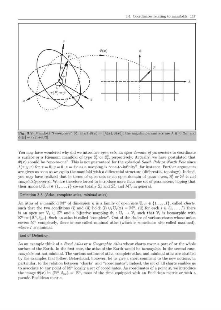
Fig. 3.2. Manifold “two-sphere” S
2
r , chart Φ(x) =
ˆ
λ(x), φ(x)
˜
: the angular parameters are λ ∈ ]0, 2π[ and
φ ∈ ] − π/2, +π/2[.
You may have wondered why did we introduce open sets, an open domain of parameters to coordinate
a surface or a Riemann manifold of type S
1
r or S
2
r , respectively. Actually, we have postulated that
Φ(x) should be “one-to-one”. This is not guaranteed for the spherical South Pole or North Pole since
λ(x, y, z) for x = 0, y = 0, z = ±r as a mapping is “one-to-infinity”, for instance. Further arguments
are given as soon as we equip the manifold with a differential structure (differential topology). Indeed,
you may have realized that in terms of open sets or an open domain of parameters, S
1
r or S
2
r is not
completely covered. We are therefore forced to introduce more than one set of parameters, hoping that
their union ∪ U i , i ∈ {1, . . . , I} covers totally S
1
r and S
2
r , and M
2 , in general.
Definition 3.3 (Atlas, complete atlas, minimal atlas).
An atlas of a manifold M
n of dimension n is a family of open sets U i , i ∈ {1, . . . , I}, called charts,
such that the two conditions (i) and (ii) hold: (i) ∪ i U i (x) = M
n , (ii) for each i ∈ {1, . . . , I} there
is an open set V i ⊂ E
n and a bijective mapping Φ i : U i → V i such that V i is isomorphic with
E
n := {R
n , δ µν }. Such an atlas is called “complete”. Out of the choice of various charts whose union
covers M
n completely, there is one called minimal atlas (which is sometimes also called maximal),
where I is minimal.
End of Definition.
As an example think of a Road Atlas or a Geographic Atlas whose charts cover a part of or the whole
surface of the Earth. In the first case, the atlas of the Earth would be incomplete. In the second case,
complete but not minimal. The various notions of atlas, complete atlas, and minimal atlas are clarified
by the examples that follow. Beforehand, however, let us give a short comment to the new notions, in
particular, to the relation between “charts” and “coordinates”. Indeed, the set of all charts enables us
to associate to any point of M
n locally a set of coordinates. As coordinates of a point x, we introduce
the image Φ(x) in {R
n , δ µν } =: E
n , most of the time equipped with an Euclidean metric or with a
pseudo-Euclidean metric.
x
y
z
φ
λ
φ
λ
Φ(x)
x
p
P
π(P ) = p
Fig. 3.2. Manifold “two-sphere” S
2
r , chart Φ(x) =
ˆ
λ(x), φ(x)
˜
: the angular parameters are λ ∈ ]0, 2π[ and
φ ∈ ] − π/2, +π/2[.
You may have wondered why did we introduce open sets, an open domain of parameters to coordinate
a surface or a Riemann manifold of type S
1
r or S
2
r , respectively. Actually, we have postulated that
Φ(x) should be “one-to-one”. This is not guaranteed for the spherical South Pole or North Pole since
λ(x, y, z) for x = 0, y = 0, z = ±r as a mapping is “one-to-infinity”, for instance. Further arguments
are given as soon as we equip the manifold with a differential structure (differential topology). Indeed,
you may have realized that in terms of open sets or an open domain of parameters, S
1
r or S
2
r is not
completely covered. We are therefore forced to introduce more than one set of parameters, hoping that
their union ∪ U i , i ∈ {1, . . . , I} covers totally S
1
r and S
2
r , and M
2 , in general.
Definition 3.3 (Atlas, complete atlas, minimal atlas).
An atlas of a manifold M
n of dimension n is a family of open sets U i , i ∈ {1, . . . , I}, called charts,
such that the two conditions (i) and (ii) hold: (i) ∪ i U i (x) = M
n , (ii) for each i ∈ {1, . . . , I} there
is an open set V i ⊂ E
n and a bijective mapping Φ i : U i → V i such that V i is isomorphic with
E
n := {R
n , δ µν }. Such an atlas is called “complete”. Out of the choice of various charts whose union
covers M
n completely, there is one called minimal atlas (which is sometimes also called maximal),
where I is minimal.
End of Definition.
As an example think of a Road Atlas or a Geographic Atlas whose charts cover a part of or the whole
surface of the Earth. In the first case, the atlas of the Earth would be incomplete. In the second case,
complete but not minimal. The various notions of atlas, complete atlas, and minimal atlas are clarified
by the examples that follow. Beforehand, however, let us give a short comment to the new notions, in
particular, to the relation between “charts” and “coordinates”. Indeed, the set of all charts enables us
to associate to any point of M
n locally a set of coordinates. As coordinates of a point x, we introduce
the image Φ(x) in {R
n , δ µν } =: E
n , most of the time equipped with an Euclidean metric or with a
pseudo-Euclidean metric.