

Copyright © National Academy of Sciences. All rights reserved.
Solar and Space Physics: A Science for a Technological Society
REPORT OF THE PANEL ON ATMOSPHERE-IONOSPHERE-MAGNETOSPHERE INTERACTIONS
185
to about 320 km, each satellite will then use on-board propulsion to re-boost to 450 km, a maneuver
that will be completed in a single orbit. Such a re-boost is a routine maneuver expected to be required
approximately once every 6 months, depending on solar activity.
The nominal plan for GDC is to have six identical satellites that will spread into six equally spaced
orbital planes separated by 30° longitude, thus providing measurements at 12 local times (LTs), with a
resolution of 2 hours of LT, as shown in Figure 8.20a. The satellites will nominally have an inclination of
80°, in order to use precession to help separate the local time planes, while maintaining adequate coverage of the high-latitude region.
Three main orbital configurations were considered by the AIMI panel:
1. Spacecraft fully spread out in latitude to provide continuous, global coverage (see Figure 8.20a);
2. Spacecraft configured as an “armada” with simultaneous, dense coverage at high latitudes alternating between polar cap regions every 45 minutes (Figure 8.20b); and
3. Satellites configured to orbit in two separated three-satellite armadas, such that three are in the
Northern Hemisphere while three are in the Southern Hemisphere, providing simultaneous coverage of
both polar regions every 45 minutes (Figure 8.20c).
Both configuration 2 and configuration 3 gather consolidated measurements at the mid- and low
latitudes, with simultaneous crossings of the equator by all six satellites every 45 minutes (Figure 8.20d),
while the entire globe is sampled every 90 minutes at 12 local times (as is the case for configuration 1). The
panel notes that only minimal amounts of propulsion are needed to alternate between these configurations
and that the “station keeping” time to change and maintain these configurations is very short.
Initial Deployment Phase and Operational Strategy
The most cost-effective launch approach (given available launchers) would be to launch all six satellites with one launcher. In this case, the satellites are first placed in a highly elliptical orbit plane (e.g.,
with perigee of 450 and apogee of 2,000 km) with an 80° inclination. As they then precess, these satellites
will spread out in equally separated local time planes (requiring ~12 months). Note that propulsion can be
used to decrease this deployment time. In this scenario, the apogee of one satellite is immediately lowered
to provide an initial 450-km circular orbit, while the remaining five satellites precess in local time. After
about 2.5 months, in which the satellites have precessed 30 degrees in local time, a second satellite orbit
is changed to 450 km circular. The process continues until all six are spread out equally and converted
to 450-km circular orbits. During the time required to establish the final distribution in local time of the
six satellites, this initial observing phase permits “pearls-on-a-string” observations by the satellites along
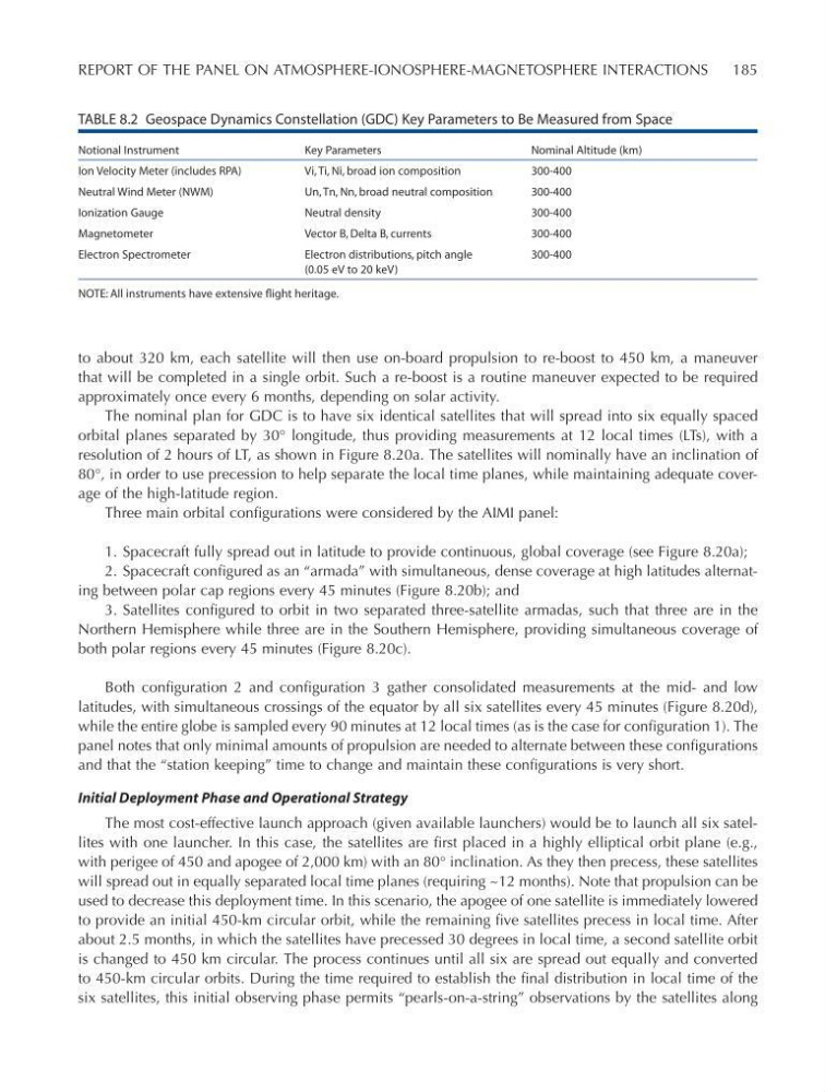
TABLE 8.2 Geospace Dynamics Constellation (GDC) Key Parameters to Be Measured from Space
Notional Instrument
Key Parameters
Nominal Altitude (km)
Ion Velocity Meter (includes RPA)
Vi, Ti, Ni, broad ion composition
300-400
Neutral Wind Meter (NWM)
Un, Tn, Nn, broad neutral composition
300-400
Ionization Gauge
Neutral density
300-400
Magnetometer
Vector B, Delta B, currents
300-400
Electron Spectrometer
Electron distributions, pitch angle
(0.05 eV to 20 keV)
300-400
NOTE: All instruments have extensive flight heritage.
Solar and Space Physics: A Science for a Technological Society
REPORT OF THE PANEL ON ATMOSPHERE-IONOSPHERE-MAGNETOSPHERE INTERACTIONS
185
to about 320 km, each satellite will then use on-board propulsion to re-boost to 450 km, a maneuver
that will be completed in a single orbit. Such a re-boost is a routine maneuver expected to be required
approximately once every 6 months, depending on solar activity.
The nominal plan for GDC is to have six identical satellites that will spread into six equally spaced
orbital planes separated by 30° longitude, thus providing measurements at 12 local times (LTs), with a
resolution of 2 hours of LT, as shown in Figure 8.20a. The satellites will nominally have an inclination of
80°, in order to use precession to help separate the local time planes, while maintaining adequate coverage of the high-latitude region.
Three main orbital configurations were considered by the AIMI panel:
1. Spacecraft fully spread out in latitude to provide continuous, global coverage (see Figure 8.20a);
2. Spacecraft configured as an “armada” with simultaneous, dense coverage at high latitudes alternating between polar cap regions every 45 minutes (Figure 8.20b); and
3. Satellites configured to orbit in two separated three-satellite armadas, such that three are in the
Northern Hemisphere while three are in the Southern Hemisphere, providing simultaneous coverage of
both polar regions every 45 minutes (Figure 8.20c).
Both configuration 2 and configuration 3 gather consolidated measurements at the mid- and low
latitudes, with simultaneous crossings of the equator by all six satellites every 45 minutes (Figure 8.20d),
while the entire globe is sampled every 90 minutes at 12 local times (as is the case for configuration 1). The
panel notes that only minimal amounts of propulsion are needed to alternate between these configurations
and that the “station keeping” time to change and maintain these configurations is very short.
Initial Deployment Phase and Operational Strategy
The most cost-effective launch approach (given available launchers) would be to launch all six satellites with one launcher. In this case, the satellites are first placed in a highly elliptical orbit plane (e.g.,
with perigee of 450 and apogee of 2,000 km) with an 80° inclination. As they then precess, these satellites
will spread out in equally separated local time planes (requiring ~12 months). Note that propulsion can be
used to decrease this deployment time. In this scenario, the apogee of one satellite is immediately lowered
to provide an initial 450-km circular orbit, while the remaining five satellites precess in local time. After
about 2.5 months, in which the satellites have precessed 30 degrees in local time, a second satellite orbit
is changed to 450 km circular. The process continues until all six are spread out equally and converted
to 450-km circular orbits. During the time required to establish the final distribution in local time of the
six satellites, this initial observing phase permits “pearls-on-a-string” observations by the satellites along
TABLE 8.2 Geospace Dynamics Constellation (GDC) Key Parameters to Be Measured from Space
Notional Instrument
Key Parameters
Nominal Altitude (km)
Ion Velocity Meter (includes RPA)
Vi, Ti, Ni, broad ion composition
300-400
Neutral Wind Meter (NWM)
Un, Tn, Nn, broad neutral composition
300-400
Ionization Gauge
Neutral density
300-400
Magnetometer
Vector B, Delta B, currents
300-400
Electron Spectrometer
Electron distributions, pitch angle
(0.05 eV to 20 keV)
300-400
NOTE: All instruments have extensive flight heritage.