

the course of the wet season. In contrast, at both the Vietnamese sites, the highest
temperatures are reached during the summer period (wet season) and the lowest
temperatures during the dry season from November until the end of March. Among
the four sites, Chieng Koi is the driest and hottest, while Muong Lum stays wetter
and cooler during the dry season, meaning that the water deficit here is less
pronounced (less arid, smaller red dotted area).
3.2.2 Hydrological Characterization of the Mae Sa Watershed
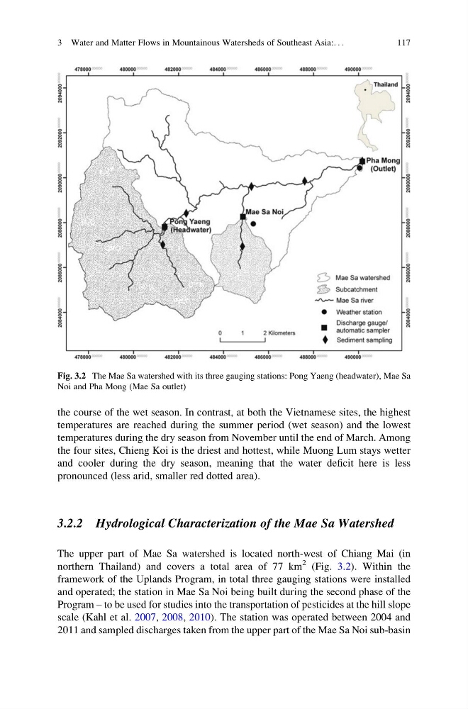
The upper part of Mae Sa watershed is located north-west of Chiang Mai (in
northern Thailand) and covers a total area of 77 km
2 (Fig. 3.2). Within the
framework of the Uplands Program, in total three gauging stations were installed
and operated; the station in Mae Sa Noi being built during the second phase of the
Program – to be used for studies into the transportation of pesticides at the hill slope
scale (Kahl et al. 2007, 2008, 2010). The station was operated between 2004 and
2011 and sampled discharges taken from the upper part of the Mae Sa Noi sub-basin
Fig. 3.2 The Mae Sa watershed with its three gauging stations: Pong Yaeng (headwater), Mae Sa
Noi and Pha Mong (Mae Sa outlet)
3 Water and Matter Flows in Mountainous Watersheds of Southeast Asia:. . .
117
temperatures are reached during the summer period (wet season) and the lowest
temperatures during the dry season from November until the end of March. Among
the four sites, Chieng Koi is the driest and hottest, while Muong Lum stays wetter
and cooler during the dry season, meaning that the water deficit here is less
pronounced (less arid, smaller red dotted area).
3.2.2 Hydrological Characterization of the Mae Sa Watershed
The upper part of Mae Sa watershed is located north-west of Chiang Mai (in
northern Thailand) and covers a total area of 77 km
2 (Fig. 3.2). Within the
framework of the Uplands Program, in total three gauging stations were installed
and operated; the station in Mae Sa Noi being built during the second phase of the
Program – to be used for studies into the transportation of pesticides at the hill slope
scale (Kahl et al. 2007, 2008, 2010). The station was operated between 2004 and
2011 and sampled discharges taken from the upper part of the Mae Sa Noi sub-basin
Fig. 3.2 The Mae Sa watershed with its three gauging stations: Pong Yaeng (headwater), Mae Sa
Noi and Pha Mong (Mae Sa outlet)
3 Water and Matter Flows in Mountainous Watersheds of Southeast Asia:. . .
117