

16.5 Spatial Organization of the Monitoring Programme
To study the potential effects of global change in a mountain range, we needed the
sampling units to be spatially distributed according to the specific objectives of the
programme and thus optimize and streamline the gathering of environmental
information. First, we identified major environmental gradients over the entire
mountain (e.g. elevation and exposure gradients). Then, the main ecosystem types
along such gradients were identified, such as natural forests (Holm oak and
Pyrenean oak forests [Quercus ilex and Q. pyrenaica], Scot pine forests [Pinus
sylvestris var. nevadensis]), high-mountain shrublands (Juniperus communis), pine
plantations, etc. These reference ecosystems, arranged over broad environmental
gradients of elevation, exposure, and orientation, became the focus of ongoing
sampling efforts. Then we installed some multiparametric meteo-stations to measure abiotic variables spatially associated with those reference ecosystems, together
with ecological data. To increase the monitoring spatial resolution we installed
wireless sensor networks around the meteo-station. These sensors collect abiotic
data taking into account topographically controlled features (Scherrer and Körner
2010). In addition, several ecological protocols take data (demography, phenology,
abundance of species, etc.) in each reference ecosystem (Aspizua et al. 2014).
Finally, data from remote sensing (e.g. snow-cover-related indicators, vegetation
indices, productivity) are gathered for the same reference ecosystem. Thus, we have
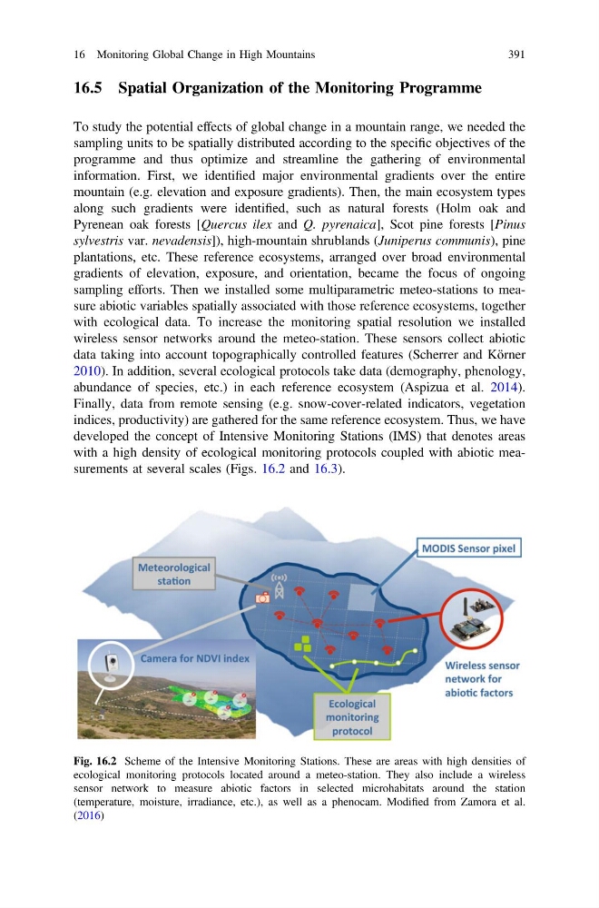
developed the concept of Intensive Monitoring Stations (IMS) that denotes areas
with a high density of ecological monitoring protocols coupled with abiotic measurements at several scales (Figs. 16.2 and 16.3).
Fig. 16.2 Scheme of the Intensive Monitoring Stations. These are areas with high densities of
ecological monitoring protocols located around a meteo-station. They also include a wireless
sensor network to measure abiotic factors in selected microhabitats around the station
(temperature, moisture, irradiance, etc.), as well as a phenocam. Modified from Zamora et al.
(2016)
16 Monitoring Global Change in High Mountains
391
To study the potential effects of global change in a mountain range, we needed the
sampling units to be spatially distributed according to the specific objectives of the
programme and thus optimize and streamline the gathering of environmental
information. First, we identified major environmental gradients over the entire
mountain (e.g. elevation and exposure gradients). Then, the main ecosystem types
along such gradients were identified, such as natural forests (Holm oak and
Pyrenean oak forests [Quercus ilex and Q. pyrenaica], Scot pine forests [Pinus
sylvestris var. nevadensis]), high-mountain shrublands (Juniperus communis), pine
plantations, etc. These reference ecosystems, arranged over broad environmental
gradients of elevation, exposure, and orientation, became the focus of ongoing
sampling efforts. Then we installed some multiparametric meteo-stations to measure abiotic variables spatially associated with those reference ecosystems, together
with ecological data. To increase the monitoring spatial resolution we installed
wireless sensor networks around the meteo-station. These sensors collect abiotic
data taking into account topographically controlled features (Scherrer and Körner
2010). In addition, several ecological protocols take data (demography, phenology,
abundance of species, etc.) in each reference ecosystem (Aspizua et al. 2014).
Finally, data from remote sensing (e.g. snow-cover-related indicators, vegetation
indices, productivity) are gathered for the same reference ecosystem. Thus, we have
developed the concept of Intensive Monitoring Stations (IMS) that denotes areas
with a high density of ecological monitoring protocols coupled with abiotic measurements at several scales (Figs. 16.2 and 16.3).
Fig. 16.2 Scheme of the Intensive Monitoring Stations. These are areas with high densities of
ecological monitoring protocols located around a meteo-station. They also include a wireless
sensor network to measure abiotic factors in selected microhabitats around the station
(temperature, moisture, irradiance, etc.), as well as a phenocam. Modified from Zamora et al.
(2016)
16 Monitoring Global Change in High Mountains
391