

Our approach takes into account the high spatial heterogeneity and ecological
diversity of the Sierra Nevada mountain range. Data are collected over a hierarchy
of spatial scales: fine scale (point and transect data); a somewhat coarser scale but
covering the entire space (e.g. pixels of satellite images, polygons of a vegetation
map); and administrative boundary scale (i.e. catchment basin, municipality). Also,
many of the sampling points that take more detail (points and transects) are spatially
aggregated in places with a high density of monitoring protocols.
Our monitoring programme incorporates the temporal dimension from two
different perspectives: (1) Historical information (including when possible the
palaeo perspective) on the structure and dynamics of the Sierra Nevada ecosystems;
and (2) Recent information, focused more on the frequency of data collection. The
purpose of the historical reconstruction is to use information about the past in
interpreting and understanding the present, and by doing so, try to predict possible
future trends. In this regard, it is important to consider the length of the series
available for each feature monitored. As with the frequency of the data collection
from recent information, we use methods that collect information according to the
processes of interest (e.g. periodicities of less than a day (weather stations) to
seasonal inventories, or at longer time scales, annually or every several years).
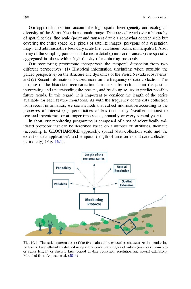
In short, our monitoring programme is composed of a set of scientifically validated protocols that can be described based on a number of attributes, thematic
(according to GLOCHAMORE approach), spatial (data-collection scale and the
extent of data application), and temporal (length of time series and data-collection
periodicity) (Fig. 16.1).
Fig. 16.1 Thematic representation of the five main attributes used to characterize the monitoring
protocols. Each attribute is defined using either continuous ranges of values (number of variables
or series length) or discrete lists (period of data collection, resolution and spatial extension).
Modified from Aspizua et al. (2014)
390
R. Zamora et al.
diversity of the Sierra Nevada mountain range. Data are collected over a hierarchy
of spatial scales: fine scale (point and transect data); a somewhat coarser scale but
covering the entire space (e.g. pixels of satellite images, polygons of a vegetation
map); and administrative boundary scale (i.e. catchment basin, municipality). Also,
many of the sampling points that take more detail (points and transects) are spatially
aggregated in places with a high density of monitoring protocols.
Our monitoring programme incorporates the temporal dimension from two
different perspectives: (1) Historical information (including when possible the
palaeo perspective) on the structure and dynamics of the Sierra Nevada ecosystems;
and (2) Recent information, focused more on the frequency of data collection. The
purpose of the historical reconstruction is to use information about the past in
interpreting and understanding the present, and by doing so, try to predict possible
future trends. In this regard, it is important to consider the length of the series
available for each feature monitored. As with the frequency of the data collection
from recent information, we use methods that collect information according to the
processes of interest (e.g. periodicities of less than a day (weather stations) to
seasonal inventories, or at longer time scales, annually or every several years).
In short, our monitoring programme is composed of a set of scientifically validated protocols that can be described based on a number of attributes, thematic
(according to GLOCHAMORE approach), spatial (data-collection scale and the
extent of data application), and temporal (length of time series and data-collection
periodicity) (Fig. 16.1).
Fig. 16.1 Thematic representation of the five main attributes used to characterize the monitoring
protocols. Each attribute is defined using either continuous ranges of values (number of variables
or series length) or discrete lists (period of data collection, resolution and spatial extension).
Modified from Aspizua et al. (2014)
390
R. Zamora et al.