

6.4 Growth Trends of Silver Fir Indicate that Dieback is
Predisposed by Past Logging
Tree-ring width was significantly (F = 6.17, P = 0.02) lower (1.9 ± 0.2 mm) in
declining than in non-declining (2.7 ± 0.1 mm) sites. In addition, the percentage of
growth variability explained by climate, calculated using multiple linear regressions, was significantly (F = 4.55, P = 0.04) higher in declining (52.3 ± 1.6%)
than in non-declining sites (45.9 ± 1.3%; Table 6.1). Such percentage was highest
(57%) in the southernmost sites (e.g. GU) which experience a greater drought stress
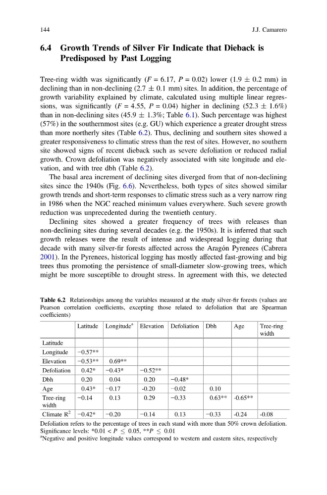
than more northerly sites (Table 6.2). Thus, declining and southern sites showed a
greater responsiveness to climatic stress than the rest of sites. However, no southern
site showed signs of recent dieback such as severe defoliation or reduced radial
growth. Crown defoliation was negatively associated with site longitude and elevation, and with tree dbh (Table 6.2).
The basal area increment of declining sites diverged from that of non-declining
sites since the 1940s (Fig. 6.6). Nevertheless, both types of sites showed similar
growth trends and short-term responses to climatic stress such as a very narrow ring
in 1986 when the NGC reached minimum values everywhere. Such severe growth
reduction was unprecedented during the twentieth century.
Declining sites showed a greater frequency of trees with releases than
non-declining sites during several decades (e.g. the 1950s). It is inferred that such
growth releases were the result of intense and widespread logging during that
decade with many silver-fir forests affected across the Aragón Pyrenees (Cabrera
2001). In the Pyrenees, historical logging has mostly affected fast-growing and big
trees thus promoting the persistence of small-diameter slow-growing trees, which
might be more susceptible to drought stress. In agreement with this, we detected
Table 6.2 Relationships among the variables measured at the study silver-fir forests (values are
Pearson correlation coefficients, excepting those related to defoliation that are Spearman
coefficients)
Latitude Longitude
a
Elevation Defoliation Dbh
Age
Tree-ring
width
Latitude
Longitude −0.57**
Elevation
−0.53**
0.69**
Defoliation
0.42*
−0.43*
−0.52**
Dbh
0.20
0.04
0.20
−0.48*
Age
0.43*
−0.17
-0.20
−0.02
0.10
Tree-ring
width
−0.14
0.13
0.29
−0.33
0.63** -0.65**
Climate R
2
−0.42*
−0.20
−0.14
0.13
−0.33
-0.24
-0.08
Defoliation refers to the percentage of trees in each stand with more than 50% crown defoliation.
Significance levels: *0.01 < P
0.05, **P
0.01
a Negative and positive longitude values correspond to western and eastern sites, respectively
144
J.J. Camarero
Predisposed by Past Logging
Tree-ring width was significantly (F = 6.17, P = 0.02) lower (1.9 ± 0.2 mm) in
declining than in non-declining (2.7 ± 0.1 mm) sites. In addition, the percentage of
growth variability explained by climate, calculated using multiple linear regressions, was significantly (F = 4.55, P = 0.04) higher in declining (52.3 ± 1.6%)
than in non-declining sites (45.9 ± 1.3%; Table 6.1). Such percentage was highest
(57%) in the southernmost sites (e.g. GU) which experience a greater drought stress
than more northerly sites (Table 6.2). Thus, declining and southern sites showed a
greater responsiveness to climatic stress than the rest of sites. However, no southern
site showed signs of recent dieback such as severe defoliation or reduced radial
growth. Crown defoliation was negatively associated with site longitude and elevation, and with tree dbh (Table 6.2).
The basal area increment of declining sites diverged from that of non-declining
sites since the 1940s (Fig. 6.6). Nevertheless, both types of sites showed similar
growth trends and short-term responses to climatic stress such as a very narrow ring
in 1986 when the NGC reached minimum values everywhere. Such severe growth
reduction was unprecedented during the twentieth century.
Declining sites showed a greater frequency of trees with releases than
non-declining sites during several decades (e.g. the 1950s). It is inferred that such
growth releases were the result of intense and widespread logging during that
decade with many silver-fir forests affected across the Aragón Pyrenees (Cabrera
2001). In the Pyrenees, historical logging has mostly affected fast-growing and big
trees thus promoting the persistence of small-diameter slow-growing trees, which
might be more susceptible to drought stress. In agreement with this, we detected
Table 6.2 Relationships among the variables measured at the study silver-fir forests (values are
Pearson correlation coefficients, excepting those related to defoliation that are Spearman
coefficients)
Latitude Longitude
a
Elevation Defoliation Dbh
Age
Tree-ring
width
Latitude
Longitude −0.57**
Elevation
−0.53**
0.69**
Defoliation
0.42*
−0.43*
−0.52**
Dbh
0.20
0.04
0.20
−0.48*
Age
0.43*
−0.17
-0.20
−0.02
0.10
Tree-ring
width
−0.14
0.13
0.29
−0.33
0.63** -0.65**
Climate R
2
−0.42*
−0.20
−0.14
0.13
−0.33
-0.24
-0.08
Defoliation refers to the percentage of trees in each stand with more than 50% crown defoliation.
Significance levels: *0.01 < P
0.05, **P
0.01
a Negative and positive longitude values correspond to western and eastern sites, respectively
144
J.J. Camarero