

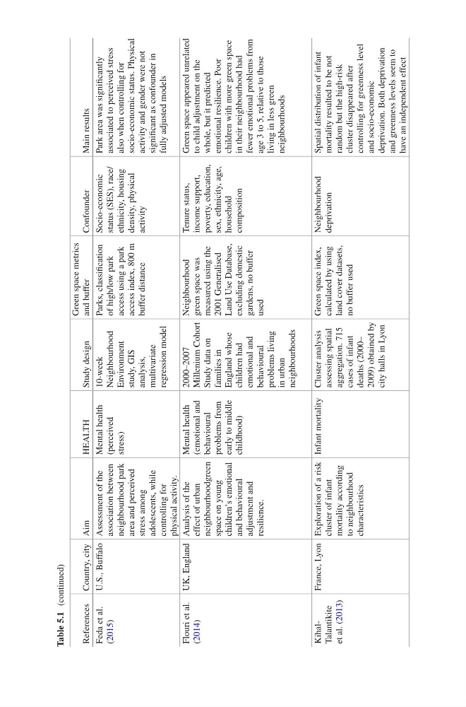
Table 5.1 (continued)
References Country, city Aim
HEALTH
Study design
Green space metrics
and buffer
Confounder
Main results
Feda et al.
(2015)
U.S., Buffalo Assessment of the
association between
neighbourhood park
area and perceived
stress among
adolescents, while
controlling for
physical activity.
Mental health
(perceived
stress)
10-week
Neighbourhood
Environment
study, GIS
analysis,
multivariate
regression model
Parks, classification
of high/low park
access using a park
access index, 800 m
buffer distance
Socio-economic
status (SES), race/
ethnicity, housing
density, physical
activity
Park area was significantly
associated to perceived stress
also when controlling for
socio-economic status. Physical
activity and gender were not
significant as confounder in
fully adjusted models
Flouri et al.
(2014)
UK, England Analysis of the
effect of urban
neighbourhoodgreen
space on young
children’s emotional
and behavioural
adjustment and
resilience.
Mental health
(emotional and
behavioural
problems from
early to middle
childhood)
2000–2007
Millenium Cohort
Study data on
families in
England whose
children had
emotional and
behavioural
problems living
in urban
neighbourhoods
Neighbourhood
green space was
measured using the
2001 Generalised
Land Use Database,
excluding domestic
gardens, no buffer
used
Tenure status,
income support,
poverty, education,
sex, ethnicity, age,
household
composition
Green space appeared unrelated
to child adjustment on the
whole, but it predicted
emotional resilience. Poor
children with more green space
in their neighbourhood had
fewer emotional problems from
age 3 to 5, relative to those
living in less green
neighbourhoods
KihalTalantikite
et al. (2013)
France, Lyon Exploration of a risk
cluster of infant
mortality according
to neighbourhood
characteristics
Infant mortality Cluster analysis
assessing spatial
aggregation. 715
cases of infant
deaths (2000–
2009) obtained by
city halls in Lyon
Green space index,
calculated by using
land cover datasets,
no buffer used
Neighbourhood
deprivation
Spatial distribution of infant
mortality resulted to be not
random but the high-risk
cluster disappeared after
controlling for greenness level
and socio- economic
deprivation. Both deprivation
and greenness levels seem to
have an independent effect
References Country, city Aim
HEALTH
Study design
Green space metrics
and buffer
Confounder
Main results
Feda et al.
(2015)
U.S., Buffalo Assessment of the
association between
neighbourhood park
area and perceived
stress among
adolescents, while
controlling for
physical activity.
Mental health
(perceived
stress)
10-week
Neighbourhood
Environment
study, GIS
analysis,
multivariate
regression model
Parks, classification
of high/low park
access using a park
access index, 800 m
buffer distance
Socio-economic
status (SES), race/
ethnicity, housing
density, physical
activity
Park area was significantly
associated to perceived stress
also when controlling for
socio-economic status. Physical
activity and gender were not
significant as confounder in
fully adjusted models
Flouri et al.
(2014)
UK, England Analysis of the
effect of urban
neighbourhoodgreen
space on young
children’s emotional
and behavioural
adjustment and
resilience.
Mental health
(emotional and
behavioural
problems from
early to middle
childhood)
2000–2007
Millenium Cohort
Study data on
families in
England whose
children had
emotional and
behavioural
problems living
in urban
neighbourhoods
Neighbourhood
green space was
measured using the
2001 Generalised
Land Use Database,
excluding domestic
gardens, no buffer
used
Tenure status,
income support,
poverty, education,
sex, ethnicity, age,
household
composition
Green space appeared unrelated
to child adjustment on the
whole, but it predicted
emotional resilience. Poor
children with more green space
in their neighbourhood had
fewer emotional problems from
age 3 to 5, relative to those
living in less green
neighbourhoods
KihalTalantikite
et al. (2013)
France, Lyon Exploration of a risk
cluster of infant
mortality according
to neighbourhood
characteristics
Infant mortality Cluster analysis
assessing spatial
aggregation. 715
cases of infant
deaths (2000–
2009) obtained by
city halls in Lyon
Green space index,
calculated by using
land cover datasets,
no buffer used
Neighbourhood
deprivation
Spatial distribution of infant
mortality resulted to be not
random but the high-risk
cluster disappeared after
controlling for greenness level
and socio- economic
deprivation. Both deprivation
and greenness levels seem to
have an independent effect