

12 Radar Systems of Maritime Transport
227
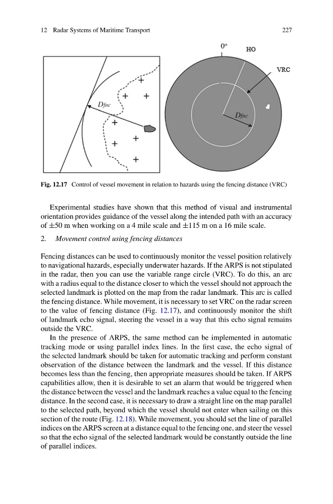
Fig. 12.17 Control of vessel movement in relation to hazards using the fencing distance (VRC)
Experimental studies have shown that this method of visual and instrumental
orientation provides guidance of the vessel along the intended path with an accuracy
of ±50 m when working on a 4 mile scale and ±115 m on a 16 mile scale.
2. Movement control using fencing distances
Fencing distances can be used to continuously monitor the vessel position relatively
to navigational hazards, especially underwater hazards. If the ARPS is not stipulated
in the radar, then you can use the variable range circle (VRC). To do this, an arc
with a radius equal to the distance closer to which the vessel should not approach the
selected landmark is plotted on the map from the radar landmark. This arc is called
the fencing distance. While movement, it is necessary to set VRC on the radar screen
to the value of fencing distance (Fig. 12.17), and continuously monitor the shift
of landmark echo signal, steering the vessel in a way that this echo signal remains
outside the VRC.
In the presence of ARPS, the same method can be implemented in automatic
tracking mode or using parallel index lines. In the first case, the echo signal of
the selected landmark should be taken for automatic tracking and perform constant
observation of the distance between the landmark and the vessel. If this distance
becomes less than the fencing, then appropriate measures should be taken. If ARPS
capabilities allow, then it is desirable to set an alarm that would be triggered when
the distance between the vessel and the landmark reaches a value equal to the fencing
distance. In the second case, it is necessary to draw a straight line on the map parallel
to the selected path, beyond which the vessel should not enter when sailing on this
section of the route (Fig. 12.18). While movement, you should set the line of parallel
indices on the ARPS screen at a distance equal to the fencing one, and steer the vessel
so that the echo signal of the selected landmark would be constantly outside the line
of parallel indices.
227
Fig. 12.17 Control of vessel movement in relation to hazards using the fencing distance (VRC)
Experimental studies have shown that this method of visual and instrumental
orientation provides guidance of the vessel along the intended path with an accuracy
of ±50 m when working on a 4 mile scale and ±115 m on a 16 mile scale.
2. Movement control using fencing distances
Fencing distances can be used to continuously monitor the vessel position relatively
to navigational hazards, especially underwater hazards. If the ARPS is not stipulated
in the radar, then you can use the variable range circle (VRC). To do this, an arc
with a radius equal to the distance closer to which the vessel should not approach the
selected landmark is plotted on the map from the radar landmark. This arc is called
the fencing distance. While movement, it is necessary to set VRC on the radar screen
to the value of fencing distance (Fig. 12.17), and continuously monitor the shift
of landmark echo signal, steering the vessel in a way that this echo signal remains
outside the VRC.
In the presence of ARPS, the same method can be implemented in automatic
tracking mode or using parallel index lines. In the first case, the echo signal of
the selected landmark should be taken for automatic tracking and perform constant
observation of the distance between the landmark and the vessel. If this distance
becomes less than the fencing, then appropriate measures should be taken. If ARPS
capabilities allow, then it is desirable to set an alarm that would be triggered when
the distance between the vessel and the landmark reaches a value equal to the fencing
distance. In the second case, it is necessary to draw a straight line on the map parallel
to the selected path, beyond which the vessel should not enter when sailing on this
section of the route (Fig. 12.18). While movement, you should set the line of parallel
indices on the ARPS screen at a distance equal to the fencing one, and steer the vessel
so that the echo signal of the selected landmark would be constantly outside the line
of parallel indices.