

9
column, while eastern ocean pressure is reduced. The resulting east-west pressure gradient is balanced by a strong eastward current right below the surface – the equatorial
undercurrent (EUC) (Cromwell 1953; Cromwell et al. 1954).
At the surface, on the other hand, the direct wind forcing and
meridional pressure gradients produce a complex system of
alternating zonal current bands (e.g., Schott et al. 2003;
Brandt et al. 2006, 2008).
The three-dimensional flow of the upper equatorial oceans
directly below the well-mixed surface layer is characterized
by a slow but steady upward motion of, at best, a few meters
per day (Rhein et al. 2010). This so-called “upwelling” is
maintained by two processes. First, the Coriolis force deflects
the off-equatorial components of the wind-induced westward displacement of surface water masses into opposite
directions. On the northern hemisphere, westward flow veers
north, while the Coriolis force directs it south on the southern hemisphere. Zonal wind-driven upper ocean mass transports diverge; they effectively transport mass away from the
equator. However, because mass is conserved, sea level sags
imperceptibly, and upwelling transports colder, subsurface
water closer to the surface by creating a “dome” in the interface between the warm surface water and cooler subsurface
water. The ratio between the surface and subsurface layer
thicknesses changes in response to the surface divergence.
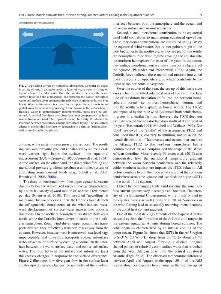
Figure 2 illustrates how divergent flow in the surface layer
creates upwelling and changes the geometry of the involved
interfaces between both the atmosphere and the ocean, and
the ocean surface and subsurface layers.
Second, a small meridional contribution to the equatorial
wind field contributes to maintaining equatorial upwelling.
These meridional contributions are illustrated in Fig. 7b by
the equatorial wind vectors that do not point straight to the
west but rather to the northwest, as they are part of the southern hemisphere trade wind regime crossing the equator into
the northern hemisphere for most of the year. In the ocean,
they induce meridional surface mass transports slightly off
the equator (Philander and Pacanowski 1981). Again, the
Coriolis force redirects these meridional motions into zonal
mass transports of opposite signs, which contribute to the
upper ocean horizontal divergence.
Over the course of the year, the set-up of this basic state
varies. Due to the tilted rotational axis of the earth, the latitude of maximum insolation shifts into the northern hemisphere in boreal – i.e. northern hemispheric – summer, and
into the southern hemisphere in boreal winter. The ITCZ,
accompanied by the trade wind systems of both hemispheres,
migrates in a similar fashion. However, the ITCZ does not
oscillate around the equator but stays north of it for most of
the year (Hastenrath 1991; Mitchell and Wallace 1992). Xie
(2004) reviewed the “riddle” of the asymmetric ITCZ and
concluded that it is, contrary to intuition, not so much the
overall distribution of landmasses and oceans that anchors
the Atlantic ITCZ to the northern hemisphere, but a
combination of air-sea coupling and the shape of the WestAfrican shoreline. More recently, Frierson et al. (2013) also
demonstrated how the meridional temperature gradient
between the warm northern hemisphere and the relatively
colder southern hemisphere impacts the ITCZ behavior. All
factors combine to pull the trade wind system of the southern
hemisphere across the equator and establish the highest SSTs
to the north of the equator.
Driven by the changing trade wind systems, the zonal surface current systems vary in strength and location. The intensity of the Equatorial Undercurrent, while firmly pinned to
the equator, varies as well (Johns et al. 2014). Variations in
the wind forcing lead to seasonally recurring intensifications
of the zonal heat content gradient.
One of the most striking elements of the tropical Atlantic
seasonal cycle is the formation of the Atlantic cold tongue in
the eastern equatorial Atlantic during boreal summer. The
cold tongue is characterized by an intense cooling of the
upper ocean. Figure 3a shows that SSTs in the Atl3 region
(3°S–3°N, 20°W–0°E) drop from 28 °C to about 23 °C
between April and August, forming a distinct, tongueshaped pattern of relatively cool surface water that stretches
from the West African coast into the central equatorial
Atlantic (Figs. 3b, c). The observed temperature difference
between April and August in the upper 50 m of the Atl3
region alone corresponds to a change in thermal energy of
Fig. 2 Upwelling driven by horizontal divergence. Consider an ocean
in a state of rest. In a simple model, a layer of warm water is sitting on
top of a layer of colder water. Both the interfaces between the warm
surface layer and the atmosphere, and between the colder subsurface
water and surface layer are approximately even (horizontal dashed blue
lines). When a divergence is created in the upper layer, mass is transported away from the divergence (light blue arrows in the surface layer).
Because water is approximately incompressible, mass must be conserved. A vertical flow from the subsurface layer compensates the horizontal divergence (dark blue, upward arrow). In reality, this domes the
interface between the surface and the subsurface layers. The sea surface
adapts to the doming interface by decreasing in a similar fashion, albeit
with a much smaller amplitude
Can Climate Models Simulate the Observed Strong Summer Surface Cooling in the Equatorial Atlantic?
column, while eastern ocean pressure is reduced. The resulting east-west pressure gradient is balanced by a strong eastward current right below the surface – the equatorial
undercurrent (EUC) (Cromwell 1953; Cromwell et al. 1954).
At the surface, on the other hand, the direct wind forcing and
meridional pressure gradients produce a complex system of
alternating zonal current bands (e.g., Schott et al. 2003;
Brandt et al. 2006, 2008).
The three-dimensional flow of the upper equatorial oceans
directly below the well-mixed surface layer is characterized
by a slow but steady upward motion of, at best, a few meters
per day (Rhein et al. 2010). This so-called “upwelling” is
maintained by two processes. First, the Coriolis force deflects
the off-equatorial components of the wind-induced westward displacement of surface water masses into opposite
directions. On the northern hemisphere, westward flow veers
north, while the Coriolis force directs it south on the southern hemisphere. Zonal wind-driven upper ocean mass transports diverge; they effectively transport mass away from the
equator. However, because mass is conserved, sea level sags
imperceptibly, and upwelling transports colder, subsurface
water closer to the surface by creating a “dome” in the interface between the warm surface water and cooler subsurface
water. The ratio between the surface and subsurface layer
thicknesses changes in response to the surface divergence.
Figure 2 illustrates how divergent flow in the surface layer
creates upwelling and changes the geometry of the involved
interfaces between both the atmosphere and the ocean, and
the ocean surface and subsurface layers.
Second, a small meridional contribution to the equatorial
wind field contributes to maintaining equatorial upwelling.
These meridional contributions are illustrated in Fig. 7b by
the equatorial wind vectors that do not point straight to the
west but rather to the northwest, as they are part of the southern hemisphere trade wind regime crossing the equator into
the northern hemisphere for most of the year. In the ocean,
they induce meridional surface mass transports slightly off
the equator (Philander and Pacanowski 1981). Again, the
Coriolis force redirects these meridional motions into zonal
mass transports of opposite signs, which contribute to the
upper ocean horizontal divergence.
Over the course of the year, the set-up of this basic state
varies. Due to the tilted rotational axis of the earth, the latitude of maximum insolation shifts into the northern hemisphere in boreal – i.e. northern hemispheric – summer, and
into the southern hemisphere in boreal winter. The ITCZ,
accompanied by the trade wind systems of both hemispheres,
migrates in a similar fashion. However, the ITCZ does not
oscillate around the equator but stays north of it for most of
the year (Hastenrath 1991; Mitchell and Wallace 1992). Xie
(2004) reviewed the “riddle” of the asymmetric ITCZ and
concluded that it is, contrary to intuition, not so much the
overall distribution of landmasses and oceans that anchors
the Atlantic ITCZ to the northern hemisphere, but a
combination of air-sea coupling and the shape of the WestAfrican shoreline. More recently, Frierson et al. (2013) also
demonstrated how the meridional temperature gradient
between the warm northern hemisphere and the relatively
colder southern hemisphere impacts the ITCZ behavior. All
factors combine to pull the trade wind system of the southern
hemisphere across the equator and establish the highest SSTs
to the north of the equator.
Driven by the changing trade wind systems, the zonal surface current systems vary in strength and location. The intensity of the Equatorial Undercurrent, while firmly pinned to
the equator, varies as well (Johns et al. 2014). Variations in
the wind forcing lead to seasonally recurring intensifications
of the zonal heat content gradient.
One of the most striking elements of the tropical Atlantic
seasonal cycle is the formation of the Atlantic cold tongue in
the eastern equatorial Atlantic during boreal summer. The
cold tongue is characterized by an intense cooling of the
upper ocean. Figure 3a shows that SSTs in the Atl3 region
(3°S–3°N, 20°W–0°E) drop from 28 °C to about 23 °C
between April and August, forming a distinct, tongueshaped pattern of relatively cool surface water that stretches
from the West African coast into the central equatorial
Atlantic (Figs. 3b, c). The observed temperature difference
between April and August in the upper 50 m of the Atl3
region alone corresponds to a change in thermal energy of
Fig. 2 Upwelling driven by horizontal divergence. Consider an ocean
in a state of rest. In a simple model, a layer of warm water is sitting on
top of a layer of colder water. Both the interfaces between the warm
surface layer and the atmosphere, and between the colder subsurface
water and surface layer are approximately even (horizontal dashed blue
lines). When a divergence is created in the upper layer, mass is transported away from the divergence (light blue arrows in the surface layer).
Because water is approximately incompressible, mass must be conserved. A vertical flow from the subsurface layer compensates the horizontal divergence (dark blue, upward arrow). In reality, this domes the
interface between the surface and the subsurface layers. The sea surface
adapts to the doming interface by decreasing in a similar fashion, albeit
with a much smaller amplitude
Can Climate Models Simulate the Observed Strong Summer Surface Cooling in the Equatorial Atlantic?