

327
12.3 Satellite Thermography Measurements
Effi cient planning of city infrastructure and its activities has to take into account
increasing average temperatures in a city, and therefore consider and monitor the
effect of its urban heat island (Zakšek and Oštir 2012 ).
Land surface temperature can be monitored with satellite systems (Colombi
et al. 2007 ). To assess the extent and state of urban heat island of Ljubljana we used
Landsat 8 imagery that has adequate spatial resolution for a detailed analysis of
temperature variations (Bechtel et al. 2012 ). Images of Ljubljana and its vicinity are
acquired twice every 16 days. Land surface temperatures were calculated from two
cloudless images per season in the period between April 15
th 2013 and March 8
th
2014.
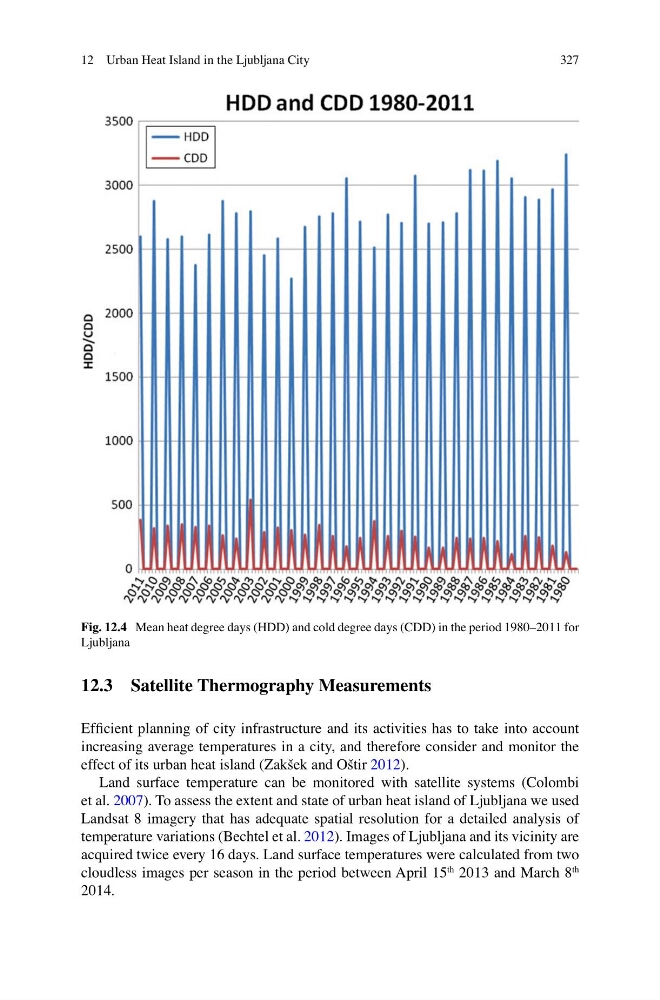
Fig. 12.4 Mean heat degree days (HDD) and cold degree days (CDD) in the period 1980–2011 for
Ljubljana
12 Urban Heat Island in the Ljubljana City
12.3 Satellite Thermography Measurements
Effi cient planning of city infrastructure and its activities has to take into account
increasing average temperatures in a city, and therefore consider and monitor the
effect of its urban heat island (Zakšek and Oštir 2012 ).
Land surface temperature can be monitored with satellite systems (Colombi
et al. 2007 ). To assess the extent and state of urban heat island of Ljubljana we used
Landsat 8 imagery that has adequate spatial resolution for a detailed analysis of
temperature variations (Bechtel et al. 2012 ). Images of Ljubljana and its vicinity are
acquired twice every 16 days. Land surface temperatures were calculated from two
cloudless images per season in the period between April 15
th 2013 and March 8
th
2014.
Fig. 12.4 Mean heat degree days (HDD) and cold degree days (CDD) in the period 1980–2011 for
Ljubljana
12 Urban Heat Island in the Ljubljana City