

326
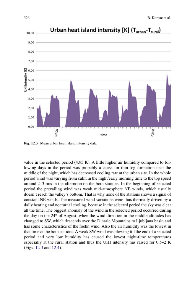
value in the selected period (4.95 K). A little higher air humidity compared to following days in the period was probably a cause for thin-fog formation near the
middle of the night, which has decreased cooling rate at the urban site. In the whole
period wind was varying from calm in the night/early morning time to the top speed
around 2–3 m/s in the afternoon on the both stations. In the beginning of selected
period the prevailing wind was weak mid-atmosphere NE winds, which usually
doesn’t reach the valley’s bottom. That is why none of the stations shows a signal of
constant NE winds. The measured wind variations were thus thermally driven by a
daily heating and nocturnal cooling, because in the selected period the sky was clear
all the time. The biggest anomaly of the wind in the selected period occurred during
the day on the 24
th of August, when the wind direction in the middle altitudes has
changed to SW, which descends over the Dinaric Mountains to Ljubljana basin and
has some characteristics of the foehn wind. Also the air humidity was the lowest in
that time at the both stations. A weak SW wind was blowing till the end of a selected
period and very low humidity has caused the lowest night-time temperatures
especially at the rural station and thus the UHI intensity has raised for 0.5–2 K
(Figs. 12.3 and 12.4 ).
Fig. 12.3 Mean urban heat island intensity data
B. Komac et al.
value in the selected period (4.95 K). A little higher air humidity compared to following days in the period was probably a cause for thin-fog formation near the
middle of the night, which has decreased cooling rate at the urban site. In the whole
period wind was varying from calm in the night/early morning time to the top speed
around 2–3 m/s in the afternoon on the both stations. In the beginning of selected
period the prevailing wind was weak mid-atmosphere NE winds, which usually
doesn’t reach the valley’s bottom. That is why none of the stations shows a signal of
constant NE winds. The measured wind variations were thus thermally driven by a
daily heating and nocturnal cooling, because in the selected period the sky was clear
all the time. The biggest anomaly of the wind in the selected period occurred during
the day on the 24
th of August, when the wind direction in the middle altitudes has
changed to SW, which descends over the Dinaric Mountains to Ljubljana basin and
has some characteristics of the foehn wind. Also the air humidity was the lowest in
that time at the both stations. A weak SW wind was blowing till the end of a selected
period and very low humidity has caused the lowest night-time temperatures
especially at the rural station and thus the UHI intensity has raised for 0.5–2 K
(Figs. 12.3 and 12.4 ).
Fig. 12.3 Mean urban heat island intensity data
B. Komac et al.