

307
with the usage of house heating stoves in places not connected to central heating
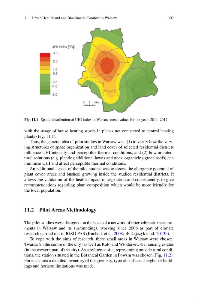
plants (Fig. 11.1 ).
Thus, the general idea of pilot studies in Warsaw was: (1) to verify how the varying structures of space organization and land cover of selected residential districts
infl uence UHI intensity and perceptible thermal conditions, and (2) how architectural solutions (e.g. planting additional lawns and trees, organizing green roofs) can
minimise UHI and affect perceptible thermal conditions.
An additional aspect of the pilot studies was to assess the allergenic potential of
plant cover (trees and bushes) growing inside the studied residential districts. It
allows the validation of the health impact of vegetation and consequently, to give
recommendations regarding plant composition which would be more friendly for
the local population.
11.2 Pilot Areas Methodology
The pilot studies were designed on the basis of a network of microclimatic measurements in Warsaw and its surroundings, working since 2006 as part of climate
research carried out in IGSO PAS (Kuchcik et al. 2008 ; Błażejczyk et al. 2013b ).
To cope with the aims of research, three small areas in Warsaw were chosen:
Twarda (in the centre of the city) as well as Koło and Włodarzewska housing estates
(in the western part of the city). As a reference site, representing outside rural conditions, the station situated in the Botanical Garden in Powsin was chosen (Fig. 11.2 ).
For each area a detailed inventory of the greenery, type of surfaces, heights of buildings and horizon limitations was made.
Fig. 11.1 Spatial distribution of UHI-index in Warsaw, mean values for the years 2011–2012
11 Urban Heat Island and Bioclimatic Comfort in Warsaw
with the usage of house heating stoves in places not connected to central heating
plants (Fig. 11.1 ).
Thus, the general idea of pilot studies in Warsaw was: (1) to verify how the varying structures of space organization and land cover of selected residential districts
infl uence UHI intensity and perceptible thermal conditions, and (2) how architectural solutions (e.g. planting additional lawns and trees, organizing green roofs) can
minimise UHI and affect perceptible thermal conditions.
An additional aspect of the pilot studies was to assess the allergenic potential of
plant cover (trees and bushes) growing inside the studied residential districts. It
allows the validation of the health impact of vegetation and consequently, to give
recommendations regarding plant composition which would be more friendly for
the local population.
11.2 Pilot Areas Methodology
The pilot studies were designed on the basis of a network of microclimatic measurements in Warsaw and its surroundings, working since 2006 as part of climate
research carried out in IGSO PAS (Kuchcik et al. 2008 ; Błażejczyk et al. 2013b ).
To cope with the aims of research, three small areas in Warsaw were chosen:
Twarda (in the centre of the city) as well as Koło and Włodarzewska housing estates
(in the western part of the city). As a reference site, representing outside rural conditions, the station situated in the Botanical Garden in Powsin was chosen (Fig. 11.2 ).
For each area a detailed inventory of the greenery, type of surfaces, heights of buildings and horizon limitations was made.
Fig. 11.1 Spatial distribution of UHI-index in Warsaw, mean values for the years 2011–2012
11 Urban Heat Island and Bioclimatic Comfort in Warsaw