

207
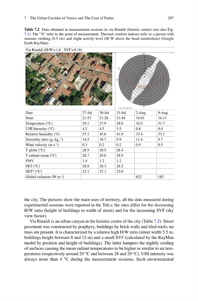
the city. The pictures show the main uses of territory, all the data measured during
experimental sessions were reported in the Tab.s; the sites differ for the decreasing
H/W ratio (height of buildings to width of street) and for the increasing SVF (sky
view factor).
Via Rinaldi is an urban canyon in the historic centre of the city (Table 7.2 ). Street
pavement was constructed by porphyry, buildings by brick walls and tiled roofs; no
trees are present. It is characterized by a relative high H/W ratio (street width 5.5 m,
buildings height between 8 and 12 m) and a small SVF (calculated by the RayMan
model by position and height of buildings). The latter hampers the nightly cooling
of surfaces causing the mean radiant temperatures to be higher or similar to air temperatures (respectively around 29 °C and between 28 and 29 °C). UHI intensity was
always more than 4 °C during the measurement sessions. Such environmental
Table 7.2 Data obtained in measurement sessions in via Rinaldi (historic centre) (see also Fig.
7.1 ). The “X” refer to the point of measurement. Thermal comfort indexes refer to a person with
summer clothing (0.5 clo) and slight activity level (80 W above the basal metabolism) (Google
Earth-RayMan)
Via Rinaldi (H/W = 1.8 - SVF = 0.18)
Date
27-Jul
30-Jul
31-Jul
2-Aug
9-Aug
Hour
21:53
21:28
21:49
16:01
16:11
Temperature (°C)
29.1
27.9
28.0
34.5
31.7
UHI Intensity (°C)
4.2
4.5
5.5
0.8
0.4
Relative humidity (%)
57.1
45.6
41.9
33.4
33.1
Humidity ratio (g v kg a
−1
)
14.5
10.7
9.9
11.4
9.7
Wind velocity (m s
−1
)
0.3
0.2
0.2
0.9
0.5
T globe (°C)
28.9
28.5
28.4
T radiant mean (°C)
28.7
29.0
28.9
PMV
1.4
1.2
1.2
PET (°C)
28.8
28.3
28.2
SET* (°C)
23.1
23.1
23.0
Global radiation (W m
−2
)
622
182
7 The Urban Corridor of Venice and The Case of Padua
the city. The pictures show the main uses of territory, all the data measured during
experimental sessions were reported in the Tab.s; the sites differ for the decreasing
H/W ratio (height of buildings to width of street) and for the increasing SVF (sky
view factor).
Via Rinaldi is an urban canyon in the historic centre of the city (Table 7.2 ). Street
pavement was constructed by porphyry, buildings by brick walls and tiled roofs; no
trees are present. It is characterized by a relative high H/W ratio (street width 5.5 m,
buildings height between 8 and 12 m) and a small SVF (calculated by the RayMan
model by position and height of buildings). The latter hampers the nightly cooling
of surfaces causing the mean radiant temperatures to be higher or similar to air temperatures (respectively around 29 °C and between 28 and 29 °C). UHI intensity was
always more than 4 °C during the measurement sessions. Such environmental
Table 7.2 Data obtained in measurement sessions in via Rinaldi (historic centre) (see also Fig.
7.1 ). The “X” refer to the point of measurement. Thermal comfort indexes refer to a person with
summer clothing (0.5 clo) and slight activity level (80 W above the basal metabolism) (Google
Earth-RayMan)
Via Rinaldi (H/W = 1.8 - SVF = 0.18)
Date
27-Jul
30-Jul
31-Jul
2-Aug
9-Aug
Hour
21:53
21:28
21:49
16:01
16:11
Temperature (°C)
29.1
27.9
28.0
34.5
31.7
UHI Intensity (°C)
4.2
4.5
5.5
0.8
0.4
Relative humidity (%)
57.1
45.6
41.9
33.4
33.1
Humidity ratio (g v kg a
−1
)
14.5
10.7
9.9
11.4
9.7
Wind velocity (m s
−1
)
0.3
0.2
0.2
0.9
0.5
T globe (°C)
28.9
28.5
28.4
T radiant mean (°C)
28.7
29.0
28.9
PMV
1.4
1.2
1.2
PET (°C)
28.8
28.3
28.2
SET* (°C)
23.1
23.1
23.0
Global radiation (W m
−2
)
622
182
7 The Urban Corridor of Venice and The Case of Padua