

5G Positioning: Security and Privacy Aspects 289
which models the shadowing and fading effects over the wireless channel. If the RSS
from several transmitters is measured and if the path‐loss coefficient n and the transmit
power P 1m [dB] are known or estimated, then the distance to several transmitters can be
estimated, and the position can be computed via trilateration, in a similar way as with
TOA trilateration. However, due to typically high shadowing variances, the n and
P 1m [dB] estimates are not accurate. Moreover, as 5G are likely to operate at high carrier
frequencies such as mm‐wave bands, and as such bands have not yet been measured or
understood properly, path‐loss models for 5G are still not well known. A few 5G path‐
loss examples can be found here [11,104].
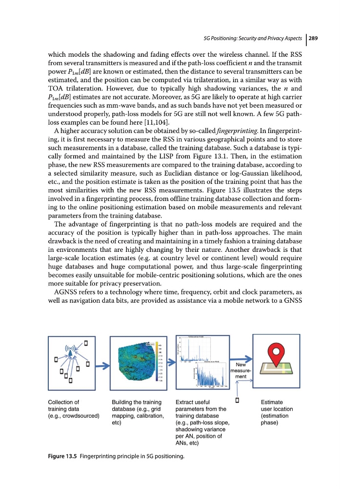
A higher accuracy solution can be obtained by so‐called fingerprinting. In fingerprinting, it is first necessary to measure the RSS in various geographical points and to store
such measurements in a database, called the training database. Such a database is typically formed and maintained by the LISP from Figure 13.1. Then, in the estimation
phase, the new RSS measurements are compared to the training database, according to
a selected similarity measure, such as Euclidian distance or log‐Gaussian likelihood,
etc., and the position estimate is taken as the position of the training point that has the
most similarities with the new RSS measurements. Figure 13.5 illustrates the steps
involved in a fingerprinting process, from offline training database collection and forming to the online positioning estimation based on mobile measurements and relevant
parameters from the training database.
The advantage of fingerprinting is that no path‐loss models are required and the
accuracy of the position is typically higher than in path‐loss approaches. The main
drawback is the need of creating and maintaining in a timely fashion a training database
in environments that are highly changing by their nature. Another drawback is that
large‐scale location estimates (e.g. at country level or continent level) would require
huge databases and huge computational power, and thus large‐scale fingerprinting
becomes easily unsuitable for mobile‐centric positioning solutions, which are the ones
more suitable for privacy preservation.
AGNSS refers to a technology where time, frequency, orbit and clock parameters, as
well as navigation data bits, are provided as assistance via a mobile network to a GNSS
New
measurement
Collection of
training data
(e.g., crowdsourced)
Building the training
database (e.g., grid
mapping, calibration,
etc)
Extract useful
parameters from the
training database
(e.g., path-loss slope,
shadowing variance
per AN, position of
ANs, etc)
Estimate
user location
(estimation
phase)
Figure 13.5 Fingerprinting principle in 5G positioning.
which models the shadowing and fading effects over the wireless channel. If the RSS
from several transmitters is measured and if the path‐loss coefficient n and the transmit
power P 1m [dB] are known or estimated, then the distance to several transmitters can be
estimated, and the position can be computed via trilateration, in a similar way as with
TOA trilateration. However, due to typically high shadowing variances, the n and
P 1m [dB] estimates are not accurate. Moreover, as 5G are likely to operate at high carrier
frequencies such as mm‐wave bands, and as such bands have not yet been measured or
understood properly, path‐loss models for 5G are still not well known. A few 5G path‐
loss examples can be found here [11,104].
A higher accuracy solution can be obtained by so‐called fingerprinting. In fingerprinting, it is first necessary to measure the RSS in various geographical points and to store
such measurements in a database, called the training database. Such a database is typically formed and maintained by the LISP from Figure 13.1. Then, in the estimation
phase, the new RSS measurements are compared to the training database, according to
a selected similarity measure, such as Euclidian distance or log‐Gaussian likelihood,
etc., and the position estimate is taken as the position of the training point that has the
most similarities with the new RSS measurements. Figure 13.5 illustrates the steps
involved in a fingerprinting process, from offline training database collection and forming to the online positioning estimation based on mobile measurements and relevant
parameters from the training database.
The advantage of fingerprinting is that no path‐loss models are required and the
accuracy of the position is typically higher than in path‐loss approaches. The main
drawback is the need of creating and maintaining in a timely fashion a training database
in environments that are highly changing by their nature. Another drawback is that
large‐scale location estimates (e.g. at country level or continent level) would require
huge databases and huge computational power, and thus large‐scale fingerprinting
becomes easily unsuitable for mobile‐centric positioning solutions, which are the ones
more suitable for privacy preservation.
AGNSS refers to a technology where time, frequency, orbit and clock parameters, as
well as navigation data bits, are provided as assistance via a mobile network to a GNSS
New
measurement
Collection of
training data
(e.g., crowdsourced)
Building the training
database (e.g., grid
mapping, calibration,
etc)
Extract useful
parameters from the
training database
(e.g., path-loss slope,
shadowing variance
per AN, position of
ANs, etc)
Estimate
user location
(estimation
phase)
Figure 13.5 Fingerprinting principle in 5G positioning.