

194
S. F. Elbeih and E. A. Zaghloul
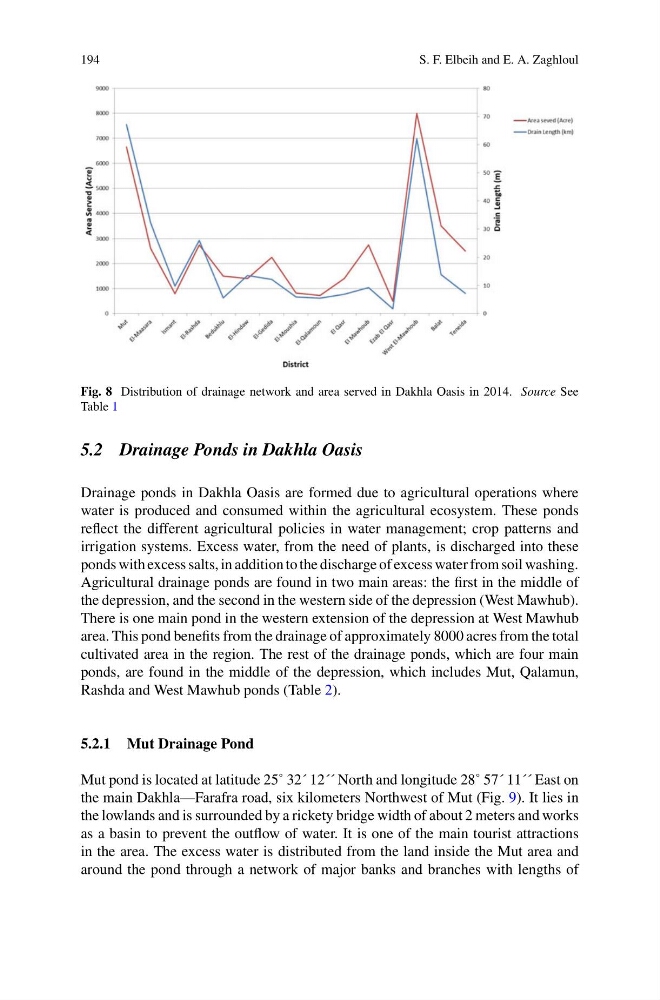
Fig. 8 Distribution of drainage network and area served in Dakhla Oasis in 2014. Source See
Table 1
5.2 Drainage Ponds in Dakhla Oasis
Drainage ponds in Dakhla Oasis are formed due to agricultural operations where
water is produced and consumed within the agricultural ecosystem. These ponds
reflect the different agricultural policies in water management; crop patterns and
irrigation systems. Excess water, from the need of plants, is discharged into these
ponds with excess salts, in addition to the discharge of excess water from soil washing.
Agricultural drainage ponds are found in two main areas: the first in the middle of
the depression, and the second in the western side of the depression (West Mawhub).
There is one main pond in the western extension of the depression at West Mawhub
area. This pond benefits from the drainage of approximately 8000 acres from the total
cultivated area in the region. The rest of the drainage ponds, which are four main
ponds, are found in the middle of the depression, which includes Mut, Qalamun,
Rashda and West Mawhub ponds (Table 2).
5.2.1 Mut Drainage Pond
Mut pond is located at latitude 25˚ 32´ 12´´ North and longitude 28˚ 57´ 11´´ East on
the main Dakhla—Farafra road, six kilometers Northwest of Mut (Fig. 9). It lies in
the lowlands and is surrounded by a rickety bridge width of about 2 meters and works
as a basin to prevent the outflow of water. It is one of the main tourist attractions
in the area. The excess water is distributed from the land inside the Mut area and
around the pond through a network of major banks and branches with lengths of
S. F. Elbeih and E. A. Zaghloul
Fig. 8 Distribution of drainage network and area served in Dakhla Oasis in 2014. Source See
Table 1
5.2 Drainage Ponds in Dakhla Oasis
Drainage ponds in Dakhla Oasis are formed due to agricultural operations where
water is produced and consumed within the agricultural ecosystem. These ponds
reflect the different agricultural policies in water management; crop patterns and
irrigation systems. Excess water, from the need of plants, is discharged into these
ponds with excess salts, in addition to the discharge of excess water from soil washing.
Agricultural drainage ponds are found in two main areas: the first in the middle of
the depression, and the second in the western side of the depression (West Mawhub).
There is one main pond in the western extension of the depression at West Mawhub
area. This pond benefits from the drainage of approximately 8000 acres from the total
cultivated area in the region. The rest of the drainage ponds, which are four main
ponds, are found in the middle of the depression, which includes Mut, Qalamun,
Rashda and West Mawhub ponds (Table 2).
5.2.1 Mut Drainage Pond
Mut pond is located at latitude 25˚ 32´ 12´´ North and longitude 28˚ 57´ 11´´ East on
the main Dakhla—Farafra road, six kilometers Northwest of Mut (Fig. 9). It lies in
the lowlands and is surrounded by a rickety bridge width of about 2 meters and works
as a basin to prevent the outflow of water. It is one of the main tourist attractions
in the area. The excess water is distributed from the land inside the Mut area and
around the pond through a network of major banks and branches with lengths of