

48
general landform in Kazakhstan is mountainous terrain in the east and southeast and
lowland in the west and northwest (Liang et al. 2017). The territory of Kazakhstan
is far from the oceans and is open to winds from the north. In addition, the climate
of Kazakhstan is continental, with an uneven distribution of precipitation. The flat
areas are usually dry and have annual precipitation from 100 mm in the southwest
to 400 mm in the north. In mountainous areas, the rainfall ranges from 400 to
1600 mm (Issanova et al. 2015). The average January temperature is −18 °C in the
north and −3 °C in the south. The average temperature in July gradually rises from
19 °C in the north to 28–30 °C in the south (Issanova et al. 2015). The main types
of ecosystems in Kazakhstan are meadows, arable land, and shrubs. From north to
south, the type of land consistently changes from arable land to pastures and shrubs.
Arable land is mainly distributed in the southern and northern border areas.
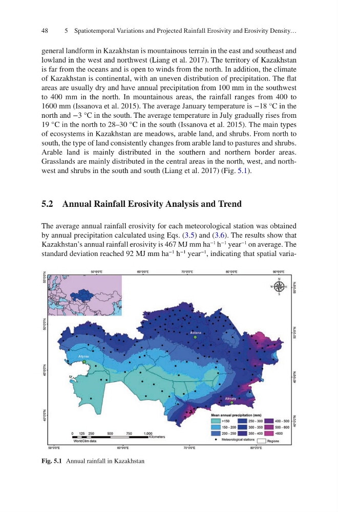
Grasslands are mainly distributed in the central areas in the north, west, and northwest and shrubs in the south and south (Liang et al. 2017) (Fig. 5.1).
5.2 Annual Rainfall Erosivity Analysis and Trend
The average annual rainfall erosivity for each meteorological station was obtained
by annual precipitation calculated using Eqs. (3.5) and (3.6). The results show that
Kazakhstan’s annual rainfall erosivity is 467 MJ mm ha
−1
h
−1
year
−1
on average. The
standard deviation reached 92 MJ mm ha
−1
h
−1
year
−1
, indicating that spatial variaFig. 5.1 Annual rainfall in Kazakhstan
5 Spatiotemporal Variations and Projected Rainfall Erosivity and Erosivity Density…
general landform in Kazakhstan is mountainous terrain in the east and southeast and
lowland in the west and northwest (Liang et al. 2017). The territory of Kazakhstan
is far from the oceans and is open to winds from the north. In addition, the climate
of Kazakhstan is continental, with an uneven distribution of precipitation. The flat
areas are usually dry and have annual precipitation from 100 mm in the southwest
to 400 mm in the north. In mountainous areas, the rainfall ranges from 400 to
1600 mm (Issanova et al. 2015). The average January temperature is −18 °C in the
north and −3 °C in the south. The average temperature in July gradually rises from
19 °C in the north to 28–30 °C in the south (Issanova et al. 2015). The main types
of ecosystems in Kazakhstan are meadows, arable land, and shrubs. From north to
south, the type of land consistently changes from arable land to pastures and shrubs.
Arable land is mainly distributed in the southern and northern border areas.
Grasslands are mainly distributed in the central areas in the north, west, and northwest and shrubs in the south and south (Liang et al. 2017) (Fig. 5.1).
5.2 Annual Rainfall Erosivity Analysis and Trend
The average annual rainfall erosivity for each meteorological station was obtained
by annual precipitation calculated using Eqs. (3.5) and (3.6). The results show that
Kazakhstan’s annual rainfall erosivity is 467 MJ mm ha
−1
h
−1
year
−1
on average. The
standard deviation reached 92 MJ mm ha
−1
h
−1
year
−1
, indicating that spatial variaFig. 5.1 Annual rainfall in Kazakhstan
5 Spatiotemporal Variations and Projected Rainfall Erosivity and Erosivity Density…