

5 An Overview of the Integrated Flood Analysis System (IFAS) …
83
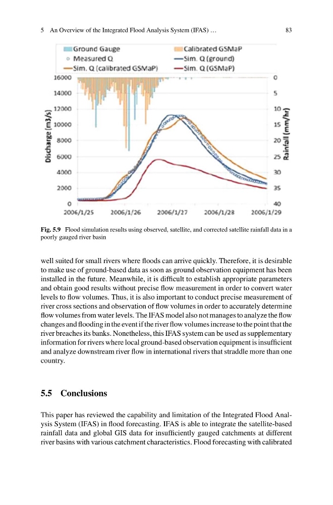
Fig. 5.9 Flood simulation results using observed, satellite, and corrected satellite rainfall data in a
poorly gauged river basin
well suited for small rivers where floods can arrive quickly. Therefore, it is desirable
to make use of ground-based data as soon as ground observation equipment has been
installed in the future. Meanwhile, it is difficult to establish appropriate parameters
and obtain good results without precise flow measurement in order to convert water
levels to flow volumes. Thus, it is also important to conduct precise measurement of
river cross sections and observation of flow volumes in order to accurately determine
flow volumes from water levels. The IFAS model also not manages to analyze the flow
changes and flooding in the event if the river flow volumes increase to the point that the
river breaches its banks. Nonetheless, this IFAS system can be used as supplementary
information for rivers where local ground-based observation equipment is insufficient
and analyze downstream river flow in international rivers that straddle more than one
country.
5.5 Conclusions
This paper has reviewed the capability and limitation of the Integrated Flood Analysis System (IFAS) in flood forecasting. IFAS is able to integrate the satellite-based
rainfall data and global GIS data for insufficiently gauged catchments at different
river basins with various catchment characteristics. Flood forecasting with calibrated
83
Fig. 5.9 Flood simulation results using observed, satellite, and corrected satellite rainfall data in a
poorly gauged river basin
well suited for small rivers where floods can arrive quickly. Therefore, it is desirable
to make use of ground-based data as soon as ground observation equipment has been
installed in the future. Meanwhile, it is difficult to establish appropriate parameters
and obtain good results without precise flow measurement in order to convert water
levels to flow volumes. Thus, it is also important to conduct precise measurement of
river cross sections and observation of flow volumes in order to accurately determine
flow volumes from water levels. The IFAS model also not manages to analyze the flow
changes and flooding in the event if the river flow volumes increase to the point that the
river breaches its banks. Nonetheless, this IFAS system can be used as supplementary
information for rivers where local ground-based observation equipment is insufficient
and analyze downstream river flow in international rivers that straddle more than one
country.
5.5 Conclusions
This paper has reviewed the capability and limitation of the Integrated Flood Analysis System (IFAS) in flood forecasting. IFAS is able to integrate the satellite-based
rainfall data and global GIS data for insufficiently gauged catchments at different
river basins with various catchment characteristics. Flood forecasting with calibrated