

82
M. F. Chow
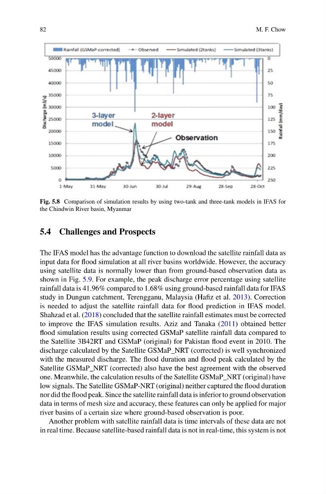
Fig. 5.8 Comparison of simulation results by using two-tank and three-tank models in IFAS for
the Chindwin River basin, Myanmar
5.4 Challenges and Prospects
The IFAS model has the advantage function to download the satellite rainfall data as
input data for flood simulation at all river basins worldwide. However, the accuracy
using satellite data is normally lower than from ground-based observation data as
shown in Fig. 5.9. For example, the peak discharge error percentage using satellite
rainfall data is 41.96% compared to 1.68% using ground-based rainfall data for IFAS
study in Dungun catchment, Terengganu, Malaysia (Hafiz et al. 2013). Correction
is needed to adjust the satellite rainfall data for flood prediction in IFAS model.
Shahzad et al. (2018) concluded that the satellite rainfall estimates must be corrected
to improve the IFAS simulation results. Aziz and Tanaka (2011) obtained better
flood simulation results using corrected GSMaP satellite rainfall data compared to
the Satellite 3B42RT and GSMaP (original) for Pakistan flood event in 2010. The
discharge calculated by the Satellite GSMaP_NRT (corrected) is well synchronized
with the measured discharge. The flood duration and flood peak calculated by the
Satellite GSMaP_NRT (corrected) also have the best agreement with the observed
one. Meanwhile, the calculation results of the Satellite GSMaP_NRT (original) have
low signals. The Satellite GSMaP-NRT (original) neither captured the flood duration
nor did the flood peak. Since the satellite rainfall data is inferior to ground observation
data in terms of mesh size and accuracy, these features can only be applied for major
river basins of a certain size where ground-based observation is poor.
Another problem with satellite rainfall data is time intervals of these data are not
in real time. Because satellite-based rainfall data is not in real-time, this system is not
M. F. Chow
Fig. 5.8 Comparison of simulation results by using two-tank and three-tank models in IFAS for
the Chindwin River basin, Myanmar
5.4 Challenges and Prospects
The IFAS model has the advantage function to download the satellite rainfall data as
input data for flood simulation at all river basins worldwide. However, the accuracy
using satellite data is normally lower than from ground-based observation data as
shown in Fig. 5.9. For example, the peak discharge error percentage using satellite
rainfall data is 41.96% compared to 1.68% using ground-based rainfall data for IFAS
study in Dungun catchment, Terengganu, Malaysia (Hafiz et al. 2013). Correction
is needed to adjust the satellite rainfall data for flood prediction in IFAS model.
Shahzad et al. (2018) concluded that the satellite rainfall estimates must be corrected
to improve the IFAS simulation results. Aziz and Tanaka (2011) obtained better
flood simulation results using corrected GSMaP satellite rainfall data compared to
the Satellite 3B42RT and GSMaP (original) for Pakistan flood event in 2010. The
discharge calculated by the Satellite GSMaP_NRT (corrected) is well synchronized
with the measured discharge. The flood duration and flood peak calculated by the
Satellite GSMaP_NRT (corrected) also have the best agreement with the observed
one. Meanwhile, the calculation results of the Satellite GSMaP_NRT (original) have
low signals. The Satellite GSMaP-NRT (original) neither captured the flood duration
nor did the flood peak. Since the satellite rainfall data is inferior to ground observation
data in terms of mesh size and accuracy, these features can only be applied for major
river basins of a certain size where ground-based observation is poor.
Another problem with satellite rainfall data is time intervals of these data are not
in real time. Because satellite-based rainfall data is not in real-time, this system is not