

distributed with depth whereas, soils formed over deciduous
trees contain a higher amount of organic matter than soils
formed over evergreen trees.
Generally, the natural vegetation cover in Libya can be
limited to Mediterranean plants, and Desert plants:
• Mediterranean plants include seasonal weeds, forest
trees and shrubs.
• Desert plants include poor steppe weeds and sparse desert dwarf shrubs.
The most important types of natural vegetation in Libya
and its distribution areas are shown (Table 3.1).
3.2.3 Relief (Topography)
Topography has a significant impact on soil formation as it
determines runoff of water, and its orientation affects
microclimate which in turn affects vegetation. In the northern region, the higher we are above sea level, the climate is
moister and cooler, and the natural vegetation is denser and
in much better condition. The topography and the shapes of
the land surface (Terrain) also have a clear effect on the
amount of water that enters into the soil, because of its
impact on the surface runoff. In addition, topography has a
significant impact on the depth of the water table level,
especially in the lowland of the northern and southern
deserts, which affects the soil formation in these regions.
Figure 3.7 shows an overview map of the regional topography (topographic divisions) in Libya.
• The plains and western high mountainous regions:
These areas extend from the Tunisian border in the west
to Misrata in the east. These areas consist of two regions:
– The coastal plains region called Jafara Plain, where the
are intensive irrigated crops, in addition to rainfed crops.
– The high mountainous region called (Nafusa Mountain), from the Tunisian land in the west to the coast of
the Al-Khums city in the east, where olive, grapes,
almonds, and other crops are grown, as well as some
forested areas of Pistacia atlantica.
• The eastern coastal region: This area extends from the
Libyan-Egyptian border to the city of Benghazi. It consists of a plateau that gradually increases in height until it
reaches 860 m in the Al Jabal Al Akhdar region and
descends toward the interior. This plateau range consists
of three regions:
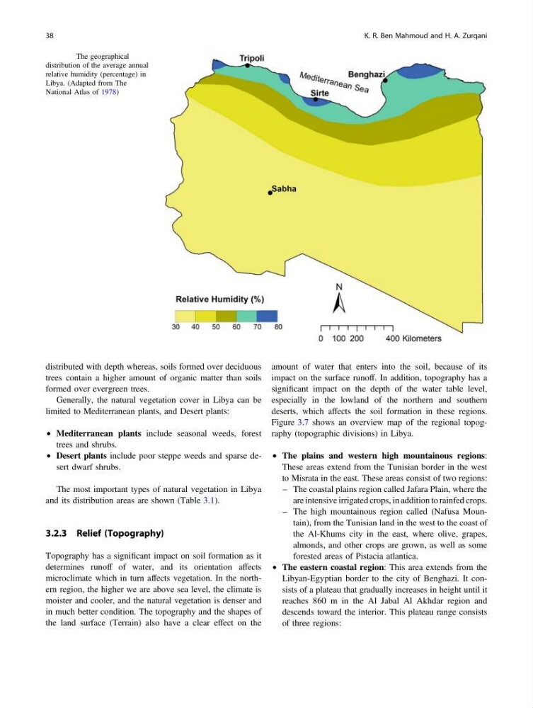
Fig. 3.5 The geographical
distribution of the average annual
relative humidity (percentage) in
Libya. (Adapted from The
National Atlas of 1978)
38
K. R. Ben Mahmoud and H. A. Zurqani
trees contain a higher amount of organic matter than soils
formed over evergreen trees.
Generally, the natural vegetation cover in Libya can be
limited to Mediterranean plants, and Desert plants:
• Mediterranean plants include seasonal weeds, forest
trees and shrubs.
• Desert plants include poor steppe weeds and sparse desert dwarf shrubs.
The most important types of natural vegetation in Libya
and its distribution areas are shown (Table 3.1).
3.2.3 Relief (Topography)
Topography has a significant impact on soil formation as it
determines runoff of water, and its orientation affects
microclimate which in turn affects vegetation. In the northern region, the higher we are above sea level, the climate is
moister and cooler, and the natural vegetation is denser and
in much better condition. The topography and the shapes of
the land surface (Terrain) also have a clear effect on the
amount of water that enters into the soil, because of its
impact on the surface runoff. In addition, topography has a
significant impact on the depth of the water table level,
especially in the lowland of the northern and southern
deserts, which affects the soil formation in these regions.
Figure 3.7 shows an overview map of the regional topography (topographic divisions) in Libya.
• The plains and western high mountainous regions:
These areas extend from the Tunisian border in the west
to Misrata in the east. These areas consist of two regions:
– The coastal plains region called Jafara Plain, where the
are intensive irrigated crops, in addition to rainfed crops.
– The high mountainous region called (Nafusa Mountain), from the Tunisian land in the west to the coast of
the Al-Khums city in the east, where olive, grapes,
almonds, and other crops are grown, as well as some
forested areas of Pistacia atlantica.
• The eastern coastal region: This area extends from the
Libyan-Egyptian border to the city of Benghazi. It consists of a plateau that gradually increases in height until it
reaches 860 m in the Al Jabal Al Akhdar region and
descends toward the interior. This plateau range consists
of three regions:
Fig. 3.5 The geographical
distribution of the average annual
relative humidity (percentage) in
Libya. (Adapted from The
National Atlas of 1978)
38
K. R. Ben Mahmoud and H. A. Zurqani