

studies, the quality and productivity of land were determined, and then a number of agricultural projects were
launched in Libya. It should be mentioned that these studies
have been conducted by a number of companies of different
nationalities. These soil studies are included below:
2.3.3.1 Studies of Soil Resources by French GEFLI
Company (1971–1978)
These studies were implemented in 20 different locations
in Libya and the mapping of soil surveys were exploratory, semidetailed and detailed. These studies considered
the interpretation of aerial images and annual rainfall rates. GEFLI soil studies did not take into account the
morphological characteristics of the soils and thus determinate their soil taxonomic units, but they conducted a
survey to determine the quality of vegetation and the
status of agricultural exploitation. Also, GEFLI studies
used the French system for determining soil properties
(GEFLI 1971–1978).
2.3.3.2 A Study of Soil Resources by Egyptian
REGWA Company (1993 and 2005)
In 1993, REGWA company studied the soil and water
resources, which are suitable in agriculture in the southern
region of Libya (Al Gatroun, Tjerhi, and Al Magdoud). One
of the main objectives of this study was the settlement of
nomads in the settlement projects in the mentioned areas.
This study included a derivation soil classification map, land
capability map, and salinity and soil depth maps using the U.
S. Soil Taxonomy system (REGWA 1993). In 2005,
REGWA company also conducted a soil and water resources
study in the Sara area with the same goals which have carried out in previous study (REGWA 2005).
2.3.3.3 A Study of Soil Resources by Russian
Selkhozprom Export Company (1980)
This study was conducted in cooperation with the Libyan
Ministry of Agriculture. This study was concerned with the
study of coastal areas that receive rainfall rates of more than
200 mm per year (3 million hectares) according to modern
soil classification of Russia.
This study was aimed at producing pedological and
interpretive soil maps such as: soil classification, land
capability, optimal land use, soil salinity, soil erosion, soil
depth, and land suitability maps at scale 1:50,000. The
Selkhozprom Export study also contained the results of field
and laboratory studies, special technical reports and combined maps of western and eastern regions at a scale of
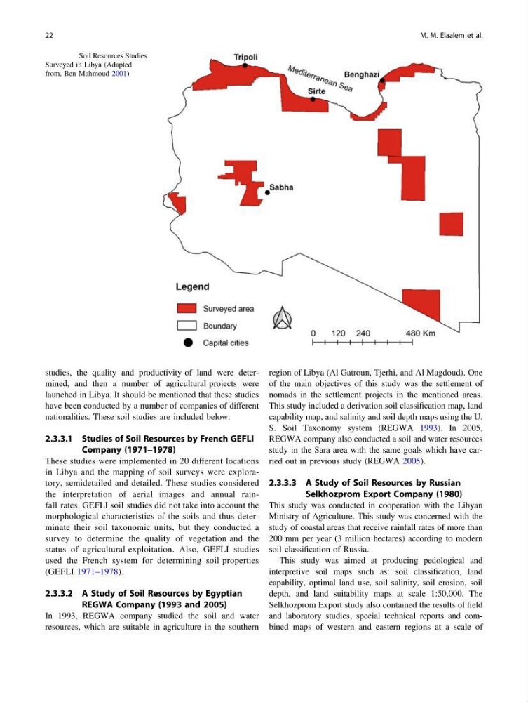
Fig. 2.12 Soil Resources Studies
Surveyed in Libya (Adapted
from, Ben Mahmoud 2001)
22
M. M. Elaalem et al.
launched in Libya. It should be mentioned that these studies
have been conducted by a number of companies of different
nationalities. These soil studies are included below:
2.3.3.1 Studies of Soil Resources by French GEFLI
Company (1971–1978)
These studies were implemented in 20 different locations
in Libya and the mapping of soil surveys were exploratory, semidetailed and detailed. These studies considered
the interpretation of aerial images and annual rainfall rates. GEFLI soil studies did not take into account the
morphological characteristics of the soils and thus determinate their soil taxonomic units, but they conducted a
survey to determine the quality of vegetation and the
status of agricultural exploitation. Also, GEFLI studies
used the French system for determining soil properties
(GEFLI 1971–1978).
2.3.3.2 A Study of Soil Resources by Egyptian
REGWA Company (1993 and 2005)
In 1993, REGWA company studied the soil and water
resources, which are suitable in agriculture in the southern
region of Libya (Al Gatroun, Tjerhi, and Al Magdoud). One
of the main objectives of this study was the settlement of
nomads in the settlement projects in the mentioned areas.
This study included a derivation soil classification map, land
capability map, and salinity and soil depth maps using the U.
S. Soil Taxonomy system (REGWA 1993). In 2005,
REGWA company also conducted a soil and water resources
study in the Sara area with the same goals which have carried out in previous study (REGWA 2005).
2.3.3.3 A Study of Soil Resources by Russian
Selkhozprom Export Company (1980)
This study was conducted in cooperation with the Libyan
Ministry of Agriculture. This study was concerned with the
study of coastal areas that receive rainfall rates of more than
200 mm per year (3 million hectares) according to modern
soil classification of Russia.
This study was aimed at producing pedological and
interpretive soil maps such as: soil classification, land
capability, optimal land use, soil salinity, soil erosion, soil
depth, and land suitability maps at scale 1:50,000. The
Selkhozprom Export study also contained the results of field
and laboratory studies, special technical reports and combined maps of western and eastern regions at a scale of
Fig. 2.12 Soil Resources Studies
Surveyed in Libya (Adapted
from, Ben Mahmoud 2001)
22
M. M. Elaalem et al.