

Hokkaido and Tohoku regions, but also in the Kanto region,
formed in the back swamps of alluvial plains, where the flat
topography is suitable for irrigation; accordingly, much of
this land has been used as rice paddies and arable fields.
Most of the peatlands in the Kanto region are used for residential and urban areas.
In Hokkaido, the total area of Organic soil is approximately 2700 km
2 , of which roughly 990 km
2 (37%) is used
for agricultural land. Natural peatlands (including wetlands)
occupy approximately 660 km
2 (Fujita et al. 1997). The total
agricultural land area of Hokkaido is approximately
11,500 km
2 , of which Organic soils account for roughly 9%
(Kanda et al. 2017). Peat soils under natural conditions are
often over-humid and have a high capacity to absorb and
retain water. Moreover, many of their chemical and physical
characteristics are not favorable for agricultural production,
including excessive amounts of soil organic material, strong
acidity, and low-bearing capacity. In order to ameliorate
these disadvantages, large-scale drainage, soil dressing, and
lime application have been carried out in Hokkaido (Hokkaido Regional Development Bureau 1979; Kondo 1997).
In Hokkaido, active surveys of peatlands used for agricultural purposes have been undertaken since the early
twentieth century. In the 1950s, the Ishikari River Basin
Development Program was proposed by the government and
funded by the World Bank. Drainage and irrigation channels
were developed, soil dressing was carried out, and much of
the land were reclaimed for rice paddies (Sakaguchi 1974;
Kondo 1997). In the late 1970s, the adjustment of rice
production forced some of the rice paddies to be converted
into upland fields, and land subsidence became problematic
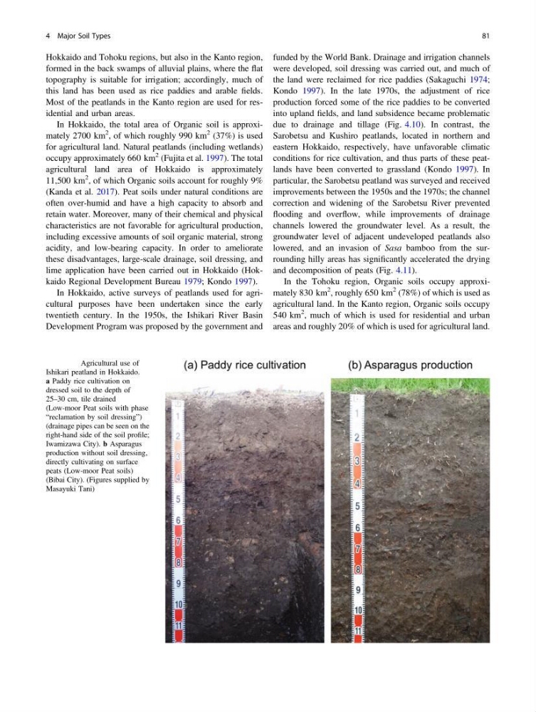
due to drainage and tillage (Fig. 4.10). In contrast, the
Sarobetsu and Kushiro peatlands, located in northern and
eastern Hokkaido, respectively, have unfavorable climatic
conditions for rice cultivation, and thus parts of these peatlands have been converted to grassland (Kondo 1997). In
particular, the Sarobetsu peatland was surveyed and received
improvements between the 1950s and the 1970s; the channel
correction and widening of the Sarobetsu River prevented
flooding and overflow, while improvements of drainage
channels lowered the groundwater level. As a result, the
groundwater level of adjacent undeveloped peatlands also
lowered, and an invasion of Sasa bamboo from the surrounding hilly areas has significantly accelerated the drying
and decomposition of peats (Fig. 4.11).
In the Tohoku region, Organic soils occupy approximately 830 km
2 , roughly 650 km
2 (78%) of which is used as
agricultural land. In the Kanto region, Organic soils occupy
540 km
2 , much of which is used for residential and urban
areas and roughly 20% of which is used for agricultural land.
Fig. 4.10 Agricultural use of
Ishikari peatland in Hokkaido.
a Paddy rice cultivation on
dressed soil to the depth of
25–30 cm, tile drained
(Low-moor Peat soils with phase
“reclamation by soil dressing”)
(drainage pipes can be seen on the
right-hand side of the soil profile;
Iwamizawa City). b Asparagus
production without soil dressing,
directly cultivating on surface
peats (Low-moor Peat soils)
(Bibai City). (Figures supplied by
Masayuki Tani)
4 Major Soil Types
81
formed in the back swamps of alluvial plains, where the flat
topography is suitable for irrigation; accordingly, much of
this land has been used as rice paddies and arable fields.
Most of the peatlands in the Kanto region are used for residential and urban areas.
In Hokkaido, the total area of Organic soil is approximately 2700 km
2 , of which roughly 990 km
2 (37%) is used
for agricultural land. Natural peatlands (including wetlands)
occupy approximately 660 km
2 (Fujita et al. 1997). The total
agricultural land area of Hokkaido is approximately
11,500 km
2 , of which Organic soils account for roughly 9%
(Kanda et al. 2017). Peat soils under natural conditions are
often over-humid and have a high capacity to absorb and
retain water. Moreover, many of their chemical and physical
characteristics are not favorable for agricultural production,
including excessive amounts of soil organic material, strong
acidity, and low-bearing capacity. In order to ameliorate
these disadvantages, large-scale drainage, soil dressing, and
lime application have been carried out in Hokkaido (Hokkaido Regional Development Bureau 1979; Kondo 1997).
In Hokkaido, active surveys of peatlands used for agricultural purposes have been undertaken since the early
twentieth century. In the 1950s, the Ishikari River Basin
Development Program was proposed by the government and
funded by the World Bank. Drainage and irrigation channels
were developed, soil dressing was carried out, and much of
the land were reclaimed for rice paddies (Sakaguchi 1974;
Kondo 1997). In the late 1970s, the adjustment of rice
production forced some of the rice paddies to be converted
into upland fields, and land subsidence became problematic
due to drainage and tillage (Fig. 4.10). In contrast, the
Sarobetsu and Kushiro peatlands, located in northern and
eastern Hokkaido, respectively, have unfavorable climatic
conditions for rice cultivation, and thus parts of these peatlands have been converted to grassland (Kondo 1997). In
particular, the Sarobetsu peatland was surveyed and received
improvements between the 1950s and the 1970s; the channel
correction and widening of the Sarobetsu River prevented
flooding and overflow, while improvements of drainage
channels lowered the groundwater level. As a result, the
groundwater level of adjacent undeveloped peatlands also
lowered, and an invasion of Sasa bamboo from the surrounding hilly areas has significantly accelerated the drying
and decomposition of peats (Fig. 4.11).
In the Tohoku region, Organic soils occupy approximately 830 km
2 , roughly 650 km
2 (78%) of which is used as
agricultural land. In the Kanto region, Organic soils occupy
540 km
2 , much of which is used for residential and urban
areas and roughly 20% of which is used for agricultural land.
Fig. 4.10 Agricultural use of
Ishikari peatland in Hokkaido.
a Paddy rice cultivation on
dressed soil to the depth of
25–30 cm, tile drained
(Low-moor Peat soils with phase
“reclamation by soil dressing”)
(drainage pipes can be seen on the
right-hand side of the soil profile;
Iwamizawa City). b Asparagus
production without soil dressing,
directly cultivating on surface
peats (Low-moor Peat soils)
(Bibai City). (Figures supplied by
Masayuki Tani)
4 Major Soil Types
81