

sand and gravel are very active. Worldwide, alluvial fans are
mainly distributed in subduction zones, such as the Japanese
Islands, or in collision zones.
Downstream of an alluvial fan, the river creates “meanders“ (Fig. 2.17); moreover, in the farthest downstream
regions, “river deltas” (Fig. 2.17) are formed where the river
flows into still water areas such as the sea or a lake. However, in rapidly flowing rivers such as the Fuji River and the
Kurobe River in Central Japan, where the mountains and the
ocean are in close proximity, alluvial fans face the sea
directly and the rivers have no deltas.
In areas facing the ocean, under the influence of the
sea-level change that occurred in the glacial to interglacial
period (see Fig. 2.8 in Sect. 2.1.3), inner bays and the
drowned valleys expanded during the interglacial period;
inner bays and the continental shelf formed land due to the
sea level lowering during the glacial period (MIS 4 to 2) and
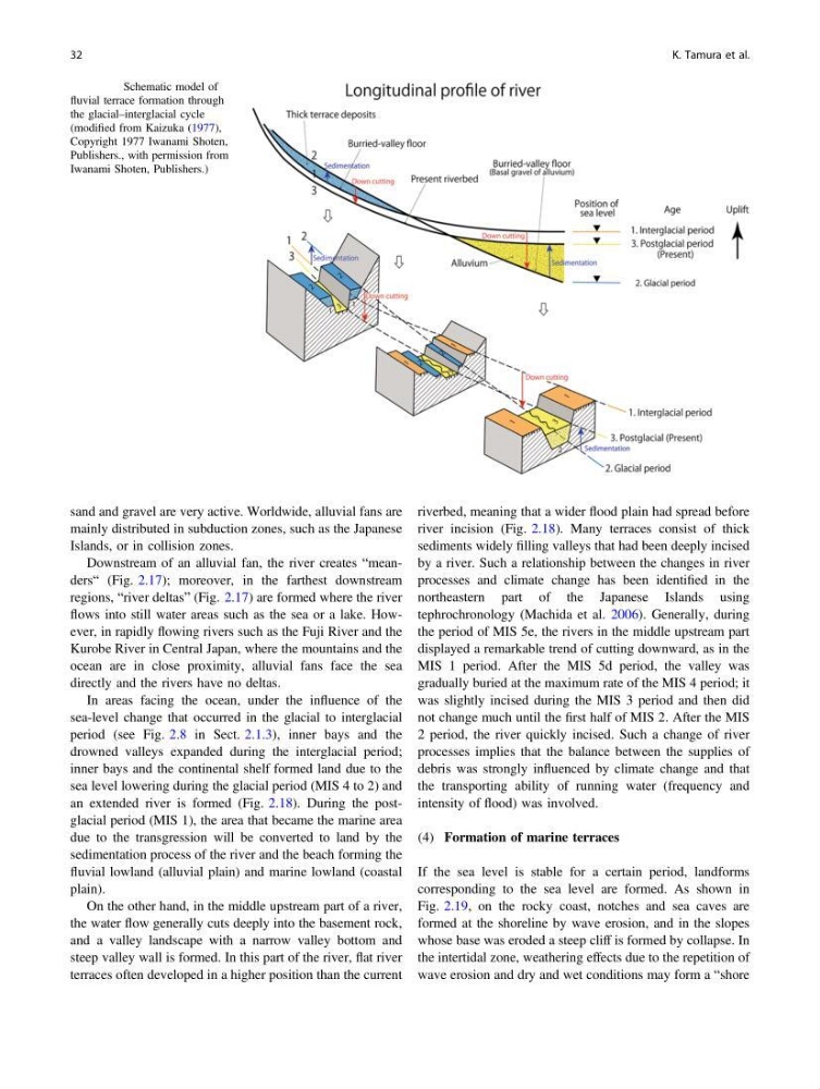
an extended river is formed (Fig. 2.18). During the postglacial period (MIS 1), the area that became the marine area
due to the transgression will be converted to land by the
sedimentation process of the river and the beach forming the
fluvial lowland (alluvial plain) and marine lowland (coastal
plain).
On the other hand, in the middle upstream part of a river,
the water flow generally cuts deeply into the basement rock,
and a valley landscape with a narrow valley bottom and
steep valley wall is formed. In this part of the river, flat river
terraces often developed in a higher position than the current
riverbed, meaning that a wider flood plain had spread before
river incision (Fig. 2.18). Many terraces consist of thick
sediments widely filling valleys that had been deeply incised
by a river. Such a relationship between the changes in river
processes and climate change has been identified in the
northeastern part of the Japanese Islands using
tephrochronology (Machida et al. 2006). Generally, during
the period of MIS 5e, the rivers in the middle upstream part
displayed a remarkable trend of cutting downward, as in the
MIS 1 period. After the MIS 5d period, the valley was
gradually buried at the maximum rate of the MIS 4 period; it
was slightly incised during the MIS 3 period and then did
not change much until the first half of MIS 2. After the MIS
2 period, the river quickly incised. Such a change of river
processes implies that the balance between the supplies of
debris was strongly influenced by climate change and that
the transporting ability of running water (frequency and
intensity of flood) was involved.
(4) Formation of marine terraces
If the sea level is stable for a certain period, landforms
corresponding to the sea level are formed. As shown in
Fig. 2.19, on the rocky coast, notches and sea caves are
formed at the shoreline by wave erosion, and in the slopes
whose base was eroded a steep cliff is formed by collapse. In
the intertidal zone, weathering effects due to the repetition of
wave erosion and dry and wet conditions may form a “shore
Fig. 2.18 Schematic model of
fluvial terrace formation through
the glacial–interglacial cycle
(modified from Kaizuka (1977),
Copyright 1977 Iwanami Shoten,
Publishers., with permission from
Iwanami Shoten, Publishers.)
32
K. Tamura et al.
mainly distributed in subduction zones, such as the Japanese
Islands, or in collision zones.
Downstream of an alluvial fan, the river creates “meanders“ (Fig. 2.17); moreover, in the farthest downstream
regions, “river deltas” (Fig. 2.17) are formed where the river
flows into still water areas such as the sea or a lake. However, in rapidly flowing rivers such as the Fuji River and the
Kurobe River in Central Japan, where the mountains and the
ocean are in close proximity, alluvial fans face the sea
directly and the rivers have no deltas.
In areas facing the ocean, under the influence of the
sea-level change that occurred in the glacial to interglacial
period (see Fig. 2.8 in Sect. 2.1.3), inner bays and the
drowned valleys expanded during the interglacial period;
inner bays and the continental shelf formed land due to the
sea level lowering during the glacial period (MIS 4 to 2) and
an extended river is formed (Fig. 2.18). During the postglacial period (MIS 1), the area that became the marine area
due to the transgression will be converted to land by the
sedimentation process of the river and the beach forming the
fluvial lowland (alluvial plain) and marine lowland (coastal
plain).
On the other hand, in the middle upstream part of a river,
the water flow generally cuts deeply into the basement rock,
and a valley landscape with a narrow valley bottom and
steep valley wall is formed. In this part of the river, flat river
terraces often developed in a higher position than the current
riverbed, meaning that a wider flood plain had spread before
river incision (Fig. 2.18). Many terraces consist of thick
sediments widely filling valleys that had been deeply incised
by a river. Such a relationship between the changes in river
processes and climate change has been identified in the
northeastern part of the Japanese Islands using
tephrochronology (Machida et al. 2006). Generally, during
the period of MIS 5e, the rivers in the middle upstream part
displayed a remarkable trend of cutting downward, as in the
MIS 1 period. After the MIS 5d period, the valley was
gradually buried at the maximum rate of the MIS 4 period; it
was slightly incised during the MIS 3 period and then did
not change much until the first half of MIS 2. After the MIS
2 period, the river quickly incised. Such a change of river
processes implies that the balance between the supplies of
debris was strongly influenced by climate change and that
the transporting ability of running water (frequency and
intensity of flood) was involved.
(4) Formation of marine terraces
If the sea level is stable for a certain period, landforms
corresponding to the sea level are formed. As shown in
Fig. 2.19, on the rocky coast, notches and sea caves are
formed at the shoreline by wave erosion, and in the slopes
whose base was eroded a steep cliff is formed by collapse. In
the intertidal zone, weathering effects due to the repetition of
wave erosion and dry and wet conditions may form a “shore
Fig. 2.18 Schematic model of
fluvial terrace formation through
the glacial–interglacial cycle
(modified from Kaizuka (1977),
Copyright 1977 Iwanami Shoten,
Publishers., with permission from
Iwanami Shoten, Publishers.)
32
K. Tamura et al.