

2.2.1 Macro-landforms and Basement
Rocks/Strata Around the Japanese Islands
(1) Macro-landforms formed by plate subduction
At least four tectonic plates are in the vicinity of the Japanese Islands: Pacific Plate, Philippine Sea Plate, North
American Plate (Okhotsk Plate) and Eurasian Plate (Amurian Plate) (Fig. 2.12). The outline of the landforms of the
Japanese Islands has mainly been formed by the subduction
of these plates (Ueda and Sugimura 1970).
The planar shape of the Japanese Islands protrudes in an
arc from the Asian continent toward the Pacific Ocean and is
termed an “island arc” based on its shape. From the viewpoint
of the land continuity, the island arc extending from the
Japanese Islands is divided into the Kuril arc from the Kamchatka Peninsula toward Hokkaido, the Honshu arc from
Hokkaido toward Honshu, the Ryukyu arc from Kyushu
toward Taiwan, the Izu-Ogasawara arc from Central Honshu
toward the Ogasawara Islands, and the Mariana arc further
south. Based on the oceanic trenches, volcanic distribution
and seismic activity, the Honshu arc is further subdivided into
the Northeast Japan arc and Southwest Japan arc (Kaizuka
1988; Matsuda and Yoshikawa 2001; Fig. 2.13).
In the offshore areas to the east and south of the Japanese
Islands, the Kuril–Kamchatka Trench, the Japan Trench, the
Mariana Trench and the Ryukyu Trench exceed depths of
6000 m; offshore of Southwest Japan from Honshu to
Kyushu, three troughs similar to the trenches are distributed
—the Sagami Trough, the Suruga Trough and the Nankai
Trough—although their depths are slightly shallower than
the trenches. These trenches and troughs are distributed
along the Pacific Ocean side of the island arc, and together
the island arc and trenches are referred to as an “island arc–
trench system”. This island arc–trench system, a typical
example of a recent mobile belt, features not only a large
topographical rise caused by crustal deformation but also
active seismic and volcanic activity (Ueda and Sugimura
1970; Fig. 2.12). The arrangement of the macro-landforms
and the basement rocks/strata along the island arc–trench
system of the Japanese Islands can be understood as unified
phenomena in the subduction zone of the plate.
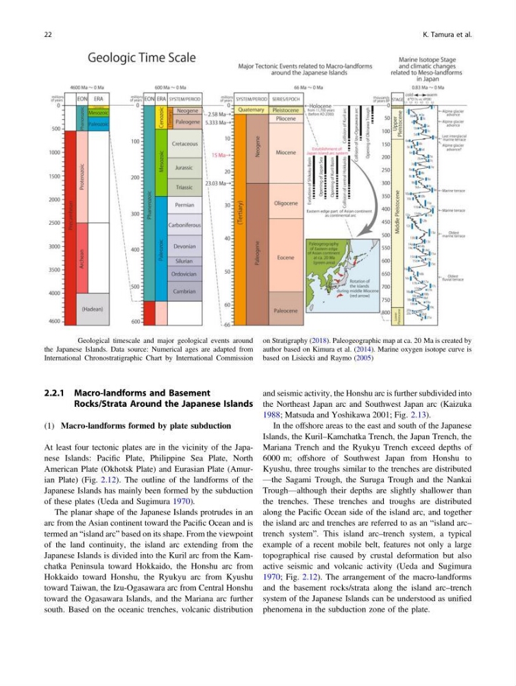
Fig. 2.11 Geological timescale and major geological events around
the Japanese Islands. Data source: Numerical ages are adapted from
International Chronostratigraphic Chart by International Commission
on Stratigraphy (2018). Paleogeographic map at ca. 20 Ma is created by
author based on Kimura et al. (2014). Marine oxygen isotope curve is
based on Lisiecki and Raymo (2005)
22
K. Tamura et al.
Rocks/Strata Around the Japanese Islands
(1) Macro-landforms formed by plate subduction
At least four tectonic plates are in the vicinity of the Japanese Islands: Pacific Plate, Philippine Sea Plate, North
American Plate (Okhotsk Plate) and Eurasian Plate (Amurian Plate) (Fig. 2.12). The outline of the landforms of the
Japanese Islands has mainly been formed by the subduction
of these plates (Ueda and Sugimura 1970).
The planar shape of the Japanese Islands protrudes in an
arc from the Asian continent toward the Pacific Ocean and is
termed an “island arc” based on its shape. From the viewpoint
of the land continuity, the island arc extending from the
Japanese Islands is divided into the Kuril arc from the Kamchatka Peninsula toward Hokkaido, the Honshu arc from
Hokkaido toward Honshu, the Ryukyu arc from Kyushu
toward Taiwan, the Izu-Ogasawara arc from Central Honshu
toward the Ogasawara Islands, and the Mariana arc further
south. Based on the oceanic trenches, volcanic distribution
and seismic activity, the Honshu arc is further subdivided into
the Northeast Japan arc and Southwest Japan arc (Kaizuka
1988; Matsuda and Yoshikawa 2001; Fig. 2.13).
In the offshore areas to the east and south of the Japanese
Islands, the Kuril–Kamchatka Trench, the Japan Trench, the
Mariana Trench and the Ryukyu Trench exceed depths of
6000 m; offshore of Southwest Japan from Honshu to
Kyushu, three troughs similar to the trenches are distributed
—the Sagami Trough, the Suruga Trough and the Nankai
Trough—although their depths are slightly shallower than
the trenches. These trenches and troughs are distributed
along the Pacific Ocean side of the island arc, and together
the island arc and trenches are referred to as an “island arc–
trench system”. This island arc–trench system, a typical
example of a recent mobile belt, features not only a large
topographical rise caused by crustal deformation but also
active seismic and volcanic activity (Ueda and Sugimura
1970; Fig. 2.12). The arrangement of the macro-landforms
and the basement rocks/strata along the island arc–trench
system of the Japanese Islands can be understood as unified
phenomena in the subduction zone of the plate.
Fig. 2.11 Geological timescale and major geological events around
the Japanese Islands. Data source: Numerical ages are adapted from
International Chronostratigraphic Chart by International Commission
on Stratigraphy (2018). Paleogeographic map at ca. 20 Ma is created by
author based on Kimura et al. (2014). Marine oxygen isotope curve is
based on Lisiecki and Raymo (2005)
22
K. Tamura et al.