

position of the polar front moving to the north and south
(Toyoda and Naruse 2002).
2.2 Geology and Geomorphology
In order to clearly understand the origin of the parent rocks
and the parent materials of soils, and their formation time
and environments in the Japanese Islands, it is necessary to
know the contents and the ages of the geology and the
landforms.
The Japanese Islands consist of the four main islands of
Hokkaido, Honshu, Shikoku and Kyushu, as well as the
adjacent Izu-Ogasawara Islands, which extend southward
from central Honshu, and the Nansei Islands, which extend
from Kyushu to Taiwan. The geographical distribution of
these major islands ranges from 24°27′ to 45°33′ N latitude
and from 148°46’ to 122°56’ E longitude. The territory of
Japan extends to Minami-Tori-shima (24°17′N, 153°59′E) in
the far east from Honshu and Okinotorishima (20°25′N, 136°
05′E) far off the southern coast of Honshu. The Japanese
Islands developed a high-relief mountain range, which
belongs to the mobile belt where seismic activity, volcanic
activity and crustal deformation are very active. A temperate
humid monsoon climate dominates around the Japanese
Islands, and the rainfall intensity at the time of typhoon passage and the rainy season is high; therefore, the topography
change due to erosion and deposition is fast and intense.
In this section, an outline is given of the formation of the
Japanese Islands as a macro-landform (on a horizontal scale of
about 100 to 1000 km) associated with basement rocks/strata.
Then, an explanation is given of the formation of volcanoes,
mountains and plains as meso- to mini-landforms (on scales of
about 1 to 100 km) with their sediments. Finally, the characteristics of the landform-covered sediments in the Japanese
Islands are described, such as air-fall sediments (pyroclastics/
tephras and eolian dust) and sediments of terrestrial plant
origin. The reader is referred to Fig. 2.11 and also Fig. 2.7 in
Sect. 2.1.3 for the names and timescales of the geological
ages in this section.
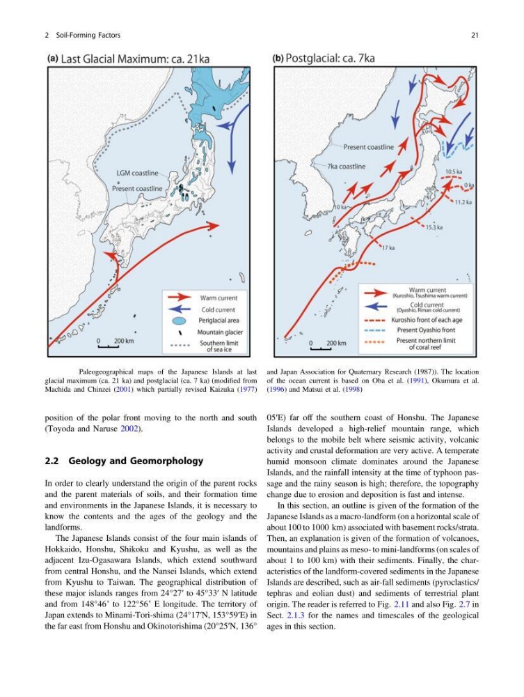
Fig. 2.10 Paleogeographical maps of the Japanese Islands at last
glacial maximum (ca. 21 ka) and postglacial (ca. 7 ka) (modified from
Machida and Chinzei (2001) which partially revised Kaizuka (1977)
and Japan Association for Quaternary Research (1987)). The location
of the ocean current is based on Oba et al. (1991), Okumura et al.
(1996) and Matsui et al. (1998)
2 Soil-Forming Factors
21
(Toyoda and Naruse 2002).
2.2 Geology and Geomorphology
In order to clearly understand the origin of the parent rocks
and the parent materials of soils, and their formation time
and environments in the Japanese Islands, it is necessary to
know the contents and the ages of the geology and the
landforms.
The Japanese Islands consist of the four main islands of
Hokkaido, Honshu, Shikoku and Kyushu, as well as the
adjacent Izu-Ogasawara Islands, which extend southward
from central Honshu, and the Nansei Islands, which extend
from Kyushu to Taiwan. The geographical distribution of
these major islands ranges from 24°27′ to 45°33′ N latitude
and from 148°46’ to 122°56’ E longitude. The territory of
Japan extends to Minami-Tori-shima (24°17′N, 153°59′E) in
the far east from Honshu and Okinotorishima (20°25′N, 136°
05′E) far off the southern coast of Honshu. The Japanese
Islands developed a high-relief mountain range, which
belongs to the mobile belt where seismic activity, volcanic
activity and crustal deformation are very active. A temperate
humid monsoon climate dominates around the Japanese
Islands, and the rainfall intensity at the time of typhoon passage and the rainy season is high; therefore, the topography
change due to erosion and deposition is fast and intense.
In this section, an outline is given of the formation of the
Japanese Islands as a macro-landform (on a horizontal scale of
about 100 to 1000 km) associated with basement rocks/strata.
Then, an explanation is given of the formation of volcanoes,
mountains and plains as meso- to mini-landforms (on scales of
about 1 to 100 km) with their sediments. Finally, the characteristics of the landform-covered sediments in the Japanese
Islands are described, such as air-fall sediments (pyroclastics/
tephras and eolian dust) and sediments of terrestrial plant
origin. The reader is referred to Fig. 2.11 and also Fig. 2.7 in
Sect. 2.1.3 for the names and timescales of the geological
ages in this section.
Fig. 2.10 Paleogeographical maps of the Japanese Islands at last
glacial maximum (ca. 21 ka) and postglacial (ca. 7 ka) (modified from
Machida and Chinzei (2001) which partially revised Kaizuka (1977)
and Japan Association for Quaternary Research (1987)). The location
of the ocean current is based on Oba et al. (1991), Okumura et al.
(1996) and Matsui et al. (1998)
2 Soil-Forming Factors
21