

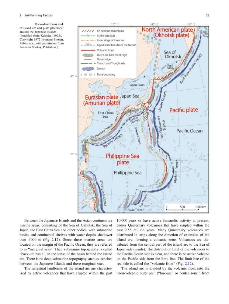
Between the Japanese Islands and the Asian continent are
marine areas, consisting of the Sea of Okhotsk, the Sea of
Japan, the East China Sea and other bodies, with submarine
basins and continental shelves with water depths shallower
than 4000 m (Fig. 2.12). Since these marine areas are
located on the margin of the Pacific Ocean, they are referred
to as “marginal seas”. Their submarine topography is called
“back-arc basin”, in the sense of the basin behind the island
arc. There is no deep submarine topography such as trenches
between the Japanese Islands and these marginal seas.
The terrestrial landforms of the island arc are characterized by active volcanoes that have erupted within the past
10,000 years or have active fumarolic activity at present,
and/or Quaternary volcanoes that have erupted within the
past 2.58 million years. Many Quaternary volcanoes are
distributed in strips along the direction of extension of the
island arc, forming a volcanic zone. Volcanoes are distributed from the central part of the island arc to the Sea of
Japan side (inside). The distribution limit of the volcanoes to
the Pacific Ocean side is clear, and there is no active volcano
on the Pacific side from the limit line. The limit line of the
sea side is called the “volcanic front” (Fig. 2.12).
The island arc is divided by the volcanic front into the
“non-volcanic outer arc” (“fore-arc” or “outer zone”: from
Fig. 2.12 Macro-landforms and
of island arc and plate placement
around the Japanese Islands
(modified from Kaizuka (1972),
Copyright 1972 Iwanami Shoten,
Publishers., with permission from
Iwanami Shoten, Publishers.)
2 Soil-Forming Factors
23
marine areas, consisting of the Sea of Okhotsk, the Sea of
Japan, the East China Sea and other bodies, with submarine
basins and continental shelves with water depths shallower
than 4000 m (Fig. 2.12). Since these marine areas are
located on the margin of the Pacific Ocean, they are referred
to as “marginal seas”. Their submarine topography is called
“back-arc basin”, in the sense of the basin behind the island
arc. There is no deep submarine topography such as trenches
between the Japanese Islands and these marginal seas.
The terrestrial landforms of the island arc are characterized by active volcanoes that have erupted within the past
10,000 years or have active fumarolic activity at present,
and/or Quaternary volcanoes that have erupted within the
past 2.58 million years. Many Quaternary volcanoes are
distributed in strips along the direction of extension of the
island arc, forming a volcanic zone. Volcanoes are distributed from the central part of the island arc to the Sea of
Japan side (inside). The distribution limit of the volcanoes to
the Pacific Ocean side is clear, and there is no active volcano
on the Pacific side from the limit line. The limit line of the
sea side is called the “volcanic front” (Fig. 2.12).
The island arc is divided by the volcanic front into the
“non-volcanic outer arc” (“fore-arc” or “outer zone”: from
Fig. 2.12 Macro-landforms and
of island arc and plate placement
around the Japanese Islands
(modified from Kaizuka (1972),
Copyright 1972 Iwanami Shoten,
Publishers., with permission from
Iwanami Shoten, Publishers.)
2 Soil-Forming Factors
23