

(Shizuoka Prefecture 2014). This sand dune is 70 km long,
0.5–3 km in width, has a layer thickness that reaches 4–5 m
or more and covers an area of 70 ha. The sand of the dune is
derived from the Tenryu River and several other rivers in
this area. The sand flowing out of the rivers accumulates by
coastal current on the lowland along the coast and the
alluvial estuary lowland. The dune was formed by sand
movement and accumulation caused by strong westerly wind
with an average wind speed in winter exceeding 7 m s
−1 .
From the end of the Edo period to the beginning of the Meiji
period, fences made of trees and bamboo were installed in
the sand dune to prevent sand blowing. Furthermore, the
dune was stabilized by the planting of Pinus thunbergii
(Kuribayashi 1956). In recent years, the supply of sand has
decreased due to the revetment of the rivers in this area, and
consequently, some areas of the sand dune have become
smaller.
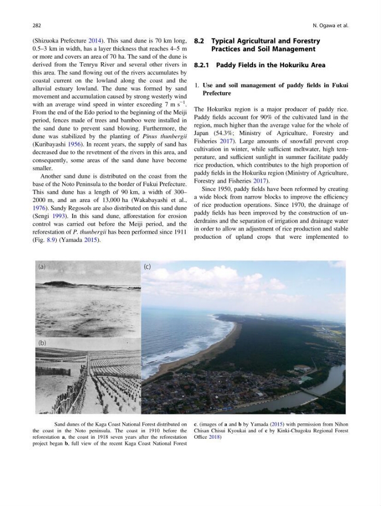
Another sand dune is distributed on the coast from the
base of the Noto Peninsula to the border of Fukui Prefecture.
This sand dune has a length of 90 km, a width of 300–
2000 m, and an area of 13,000 ha (Wakabayashi et al.,
1976). Sandy Regosols are also distributed on this sand dune
(Sengi 1993). In this sand dune, afforestation for erosion
control was carried out before the Meiji period, and the
reforestation of P. thunbergii has been performed since 1911
(Fig. 8.9) (Yamada 2015).
8.2 Typical Agricultural and Forestry
Practices and Soil Management
8.2.1 Paddy Fields in the Hokuriku Area
1. Use and soil management of paddy fields in Fukui
Prefecture
The Hokuriku region is a major producer of paddy rice.
Paddy fields account for 90% of the cultivated land in the
region, much higher than the average value for the whole of
Japan (54.3%; Ministry of Agriculture, Forestry and
Fisheries 2017). Large amounts of snowfall prevent crop
cultivation in winter, while sufficient meltwater, high temperature, and sufficient sunlight in summer facilitate paddy
rice production, which contributes to the high proportion of
paddy fields in the Hokuriku region (Ministry of Agriculture,
Forestry and Fisheries 2017).
Since 1950, paddy fields have been reformed by creating
a wide block from narrow blocks to improve the efficiency
of rice production operations. Since 1970, the drainage of
paddy fields has been improved by the construction of underdrains and the separation of irrigation and drainage water
in order to allow an adjustment of rice production and stable
production of upland crops that were implemented to
Fig. 8.9 Sand dunes of the Kaga Coast National Forest distributed on
the coast in the Noto peninsula. The coast in 1910 before the
reforestation a, the coast in 1918 seven years after the reforestation
project began b, full view of the recent Kaga Coast National Forest
c. (images of a and b by Yamada (2015) with permission from Nihon
Chisan Chisui Kyoukai and of c by Kinki-Chugoku Regional Forest
Office 2018)
282
N. Ogawa et al.
0.5–3 km in width, has a layer thickness that reaches 4–5 m
or more and covers an area of 70 ha. The sand of the dune is
derived from the Tenryu River and several other rivers in
this area. The sand flowing out of the rivers accumulates by
coastal current on the lowland along the coast and the
alluvial estuary lowland. The dune was formed by sand
movement and accumulation caused by strong westerly wind
with an average wind speed in winter exceeding 7 m s
−1 .
From the end of the Edo period to the beginning of the Meiji
period, fences made of trees and bamboo were installed in
the sand dune to prevent sand blowing. Furthermore, the
dune was stabilized by the planting of Pinus thunbergii
(Kuribayashi 1956). In recent years, the supply of sand has
decreased due to the revetment of the rivers in this area, and
consequently, some areas of the sand dune have become
smaller.
Another sand dune is distributed on the coast from the
base of the Noto Peninsula to the border of Fukui Prefecture.
This sand dune has a length of 90 km, a width of 300–
2000 m, and an area of 13,000 ha (Wakabayashi et al.,
1976). Sandy Regosols are also distributed on this sand dune
(Sengi 1993). In this sand dune, afforestation for erosion
control was carried out before the Meiji period, and the
reforestation of P. thunbergii has been performed since 1911
(Fig. 8.9) (Yamada 2015).
8.2 Typical Agricultural and Forestry
Practices and Soil Management
8.2.1 Paddy Fields in the Hokuriku Area
1. Use and soil management of paddy fields in Fukui
Prefecture
The Hokuriku region is a major producer of paddy rice.
Paddy fields account for 90% of the cultivated land in the
region, much higher than the average value for the whole of
Japan (54.3%; Ministry of Agriculture, Forestry and
Fisheries 2017). Large amounts of snowfall prevent crop
cultivation in winter, while sufficient meltwater, high temperature, and sufficient sunlight in summer facilitate paddy
rice production, which contributes to the high proportion of
paddy fields in the Hokuriku region (Ministry of Agriculture,
Forestry and Fisheries 2017).
Since 1950, paddy fields have been reformed by creating
a wide block from narrow blocks to improve the efficiency
of rice production operations. Since 1970, the drainage of
paddy fields has been improved by the construction of underdrains and the separation of irrigation and drainage water
in order to allow an adjustment of rice production and stable
production of upland crops that were implemented to
Fig. 8.9 Sand dunes of the Kaga Coast National Forest distributed on
the coast in the Noto peninsula. The coast in 1910 before the
reforestation a, the coast in 1918 seven years after the reforestation
project began b, full view of the recent Kaga Coast National Forest
c. (images of a and b by Yamada (2015) with permission from Nihon
Chisan Chisui Kyoukai and of c by Kinki-Chugoku Regional Forest
Office 2018)
282
N. Ogawa et al.